high risk
-
Posts
3,280 -
Joined
-
Last visited
Content Type
Profiles
Blogs
Forums
American Weather
Media Demo
Store
Gallery
Everything posted by high risk
-
I remember that storm really well. That was an incredible thump - the precip arrived like a wall of white.
-
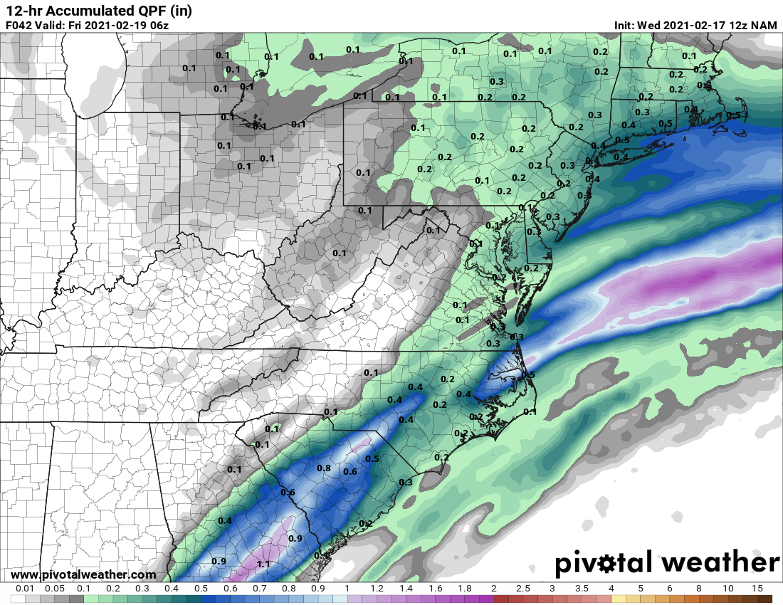
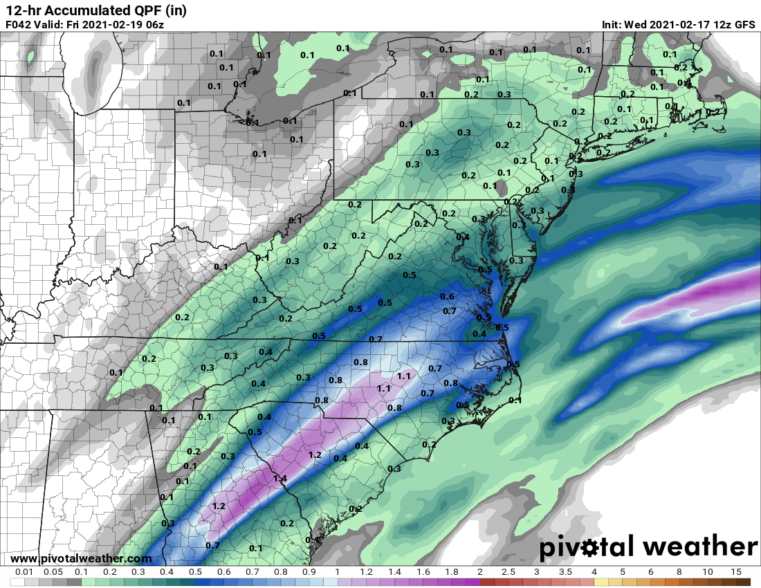
Still some pretty decent difference between the GFS/GFSpara and the NAM for the late day/overnight precip. GFS is a big hit of ice during that period for most of the metro, but it still seems to be an outlier. Even the wetter para keeps its ice threat further southeast.
-
I'll agree with that, but while I might delay its timeline for the transition by an hour, I don't know that I'd bet against it for much longer. If it is an hour, though, I hope that we get 2"/hour rates during that period.....
-
I think that scenario would be "heavily-rimed snow". It will still accumulate but at a reduced ratio. I think the idea of less-than-pure-snow is what the NAM nest has in mind, as the Ferrier accumulation on TT shows really, really low amounts. It does that when the rime factor (accounting for supercooled water building on falling snowflakes in an environment that promotes partial melting) of the falling precip is pretty high. I think that the amounts being shown on these maps today is too low, but it is telling me that we're going to be walking a fine line between precip types.
-
The NAM nest would probably cut those totals down a bit due to an earlier changeover to sleet. Not saying that the nest will be right, but that would be how we bust low. Hoping that enough liquid comes in at the start so that we can still pile up several inches, even with early mixing.
-
I'm really blown away by the lingering discrepancies with precip later in the day Thursday into the overnight. The NAM (and NAM nest) continue to have only light precip over much of the area with perhaps a bit more for eastern sections (where some significant ice may fall over southern MD and parts of the Eastern Shore) area The GFS, however is so much wetter and has some big ice accumulations for a lot of folks: The GFS para looks much like the ops does. The CAMs overall favor drier solutions, although the NMMB is a bit wetter. I'm struggling to sort this out....


-
yes - all of the high-resolution models.
-
really good agreement among most of the CAMs (NAM nest, WRF NMMB, WRF ARW, WRF NSSL ARW) of ice storm warning criteria being met in southern MD.
-
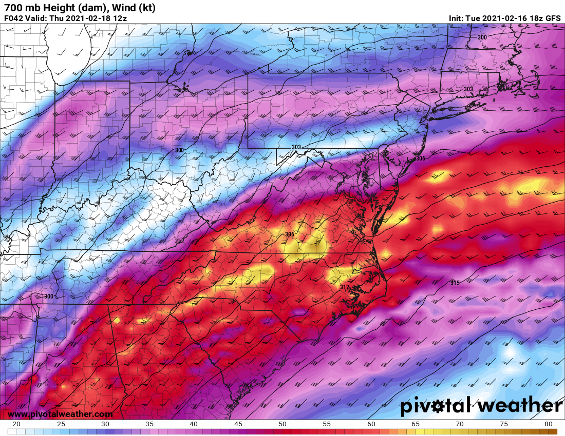
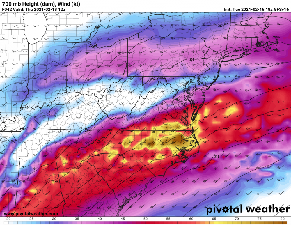
Yeah, the GFS para seems to be somewhat on its own. You can see it in the 700 winds, which are much weaker up along and south of I-66. I haven't look into why v16 is weaker, but the much reduced convergence early Thursday over northern VA and the DC area is very clear.

-
Interesting that the GFS para again focuses the initial thump further south. The northern areas score, but it's actually during the afternoon. It's also more aggressive than the ops with moving the changeover line further north. Verbatim, it hits southern areas with a lot of snow in the morning and hits northern areas with a lot of snow in the afternoon - there is an impressive screw zone running along I-50 from DC to Annapolis.
-
Just an FYI: the different sites do not compute their own instantaneous precip type - that is an output directly out of the models.
-
I guess I have it in my head that there may be a warm layer somewhere in the column for most of the area by later Thursday afternoon, but that's based off of the NAM/NAM nest, which still seem to have some outlier synoptic differences.
-
The GFS para total snow maps look nice, but when you parse the details, it focuses the thump over DC and points south; it's quite a bit less for those of us further north. It does big another slug of snow through the northern areas later in the day, though, so the storm total maps end up looking like a win for everyone. But it definitely has some details that are quite different from the ops GFS.
-

Feb Long Range Discussion (Day 3 and beyond) - MERGED
high risk replied to WinterWxLuvr's topic in Mid Atlantic
I think that we should be all be spooked at least a little, but it's just so darned different from pretty much everything else that I'm still going with "synoptic outlier". -
Feb Long Range Discussion (Day 3 and beyond) - MERGED
high risk replied to WinterWxLuvr's topic in Mid Atlantic
18z NAM still does not want to board the train to Thumpville -
Feb Long Range Discussion (Day 3 and beyond) - MERGED
high risk replied to WinterWxLuvr's topic in Mid Atlantic
GFS para is a T-H-U-M-P. Over 1" of liquid in the 12 hours ending at 18z Thursday. -
Feb Long Range Discussion (Day 3 and beyond) - MERGED
high risk replied to WinterWxLuvr's topic in Mid Atlantic
Yeah, it doesn't have a systematic cold bias overall, but it can run a bit cold in terms of trying to cool columns in marginal winter events with strong lift. It's also worth noting that it can overdo the strength of the warm nose, usually by cranking up and veering the flow too much between 850 and 700. I know we're all looking for reasons to toss its solution that really minimizes the front end thump of snow Thursday. While it's justifiable to note several times this winter when it has sniffed out some important trends, the NAM feels like a bit of synoptic outlier right now, although I would absolutely not put any money on that. -
Feb Long Range Discussion (Day 3 and beyond) - MERGED
high risk replied to WinterWxLuvr's topic in Mid Atlantic
Honestly, I just threw in that "outside the DC Beltway" disclaimer to match details of the GFS para output that are worthless at this range. I can't figure out why it has snow on either side of DC at the start with sleet over DC, but I'd think that DC is still in the game for at least a minor initial thump, and with the trends you note, maybe we can aim even a bit higher. -
Feb Long Range Discussion (Day 3 and beyond) - MERGED
high risk replied to WinterWxLuvr's topic in Mid Atlantic
That's a good point. When the ops GFS shows a decent cold air damming signal, you have to take notice, as it loves to mix things out quickly and switch the winds to a southerly component. Both versions of the GFS (and other guidance) have a signal of a weak low trying to form along the coast - that setup with a dying low coming in from the west and a weak system forming to our east or southeast (has to be weak to not crank up the onshore flow) usually works very well for damming. -
Feb Long Range Discussion (Day 3 and beyond) - MERGED
high risk replied to WinterWxLuvr's topic in Mid Atlantic
correct. Still not great but a clear step forward. -
Feb Long Range Discussion (Day 3 and beyond) - MERGED
high risk replied to WinterWxLuvr's topic in Mid Atlantic
I'm going to focus on the GFS para entirely, because the original schedule would have made this the operational by now.... (The delay had nothing to do with model skill; some adjustments were needed to make it run a little faster to avoid delays for downstream systems). While it still turns everyone over to ZR/IP/RA by the end of the day 1) it comes in with an impressive thump of snow for those north of I-66 (VA) and 50 (MD) and outside the DC Beltway 2) has over 1" of liquid for the northern half of the area 3) keeps areas west and northwest of I-95 below freezing for most of the day Verbatim, it's a winter storm for most, and the northern areas (and maybe as far south as Baltimore/Howard/Montgomery/Loudoun) are still in the game for 4-6" of snow before a transition. -
Feb Long Range Discussion (Day 3 and beyond) - MERGED
high risk replied to WinterWxLuvr's topic in Mid Atlantic
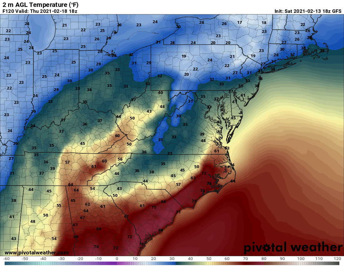
Yep. Starts the day in the mid 20s and has steady precip falling with light winds - that is not going to displace the low-level cold air easily..... 00z Canadian run looks similar. -
Feb Long Range Discussion (Day 3 and beyond) - MERGED
high risk replied to WinterWxLuvr's topic in Mid Atlantic
Toss the GFS temperatures for later Thursday. The early morning temps are in the 20s, and winds are light - the GFS is always way too aggressive in weakening the damming in setups like these. The GFS para is better at retaining the low-level cold air (not great, but better than the ops GFS) and offers a colder and more reasonable solution. -
Feb Long Range Discussion (Day 3 and beyond) - MERGED
high risk replied to WinterWxLuvr's topic in Mid Atlantic
Regarding Thursday, we all know that the GFS is terrible with cold air damming, and the evaluation period for the GFS para found that it was notably better (still not great). Assuming some skill with the synoptic details, we can see evidence that Thursday will be colder here, especially in the morning hours: Not saying that this will be a snowstorm, but the chance of another ice/sleet event is probably higher than we realize right now, especially if the precip arrives in the overnight hours Wednesday.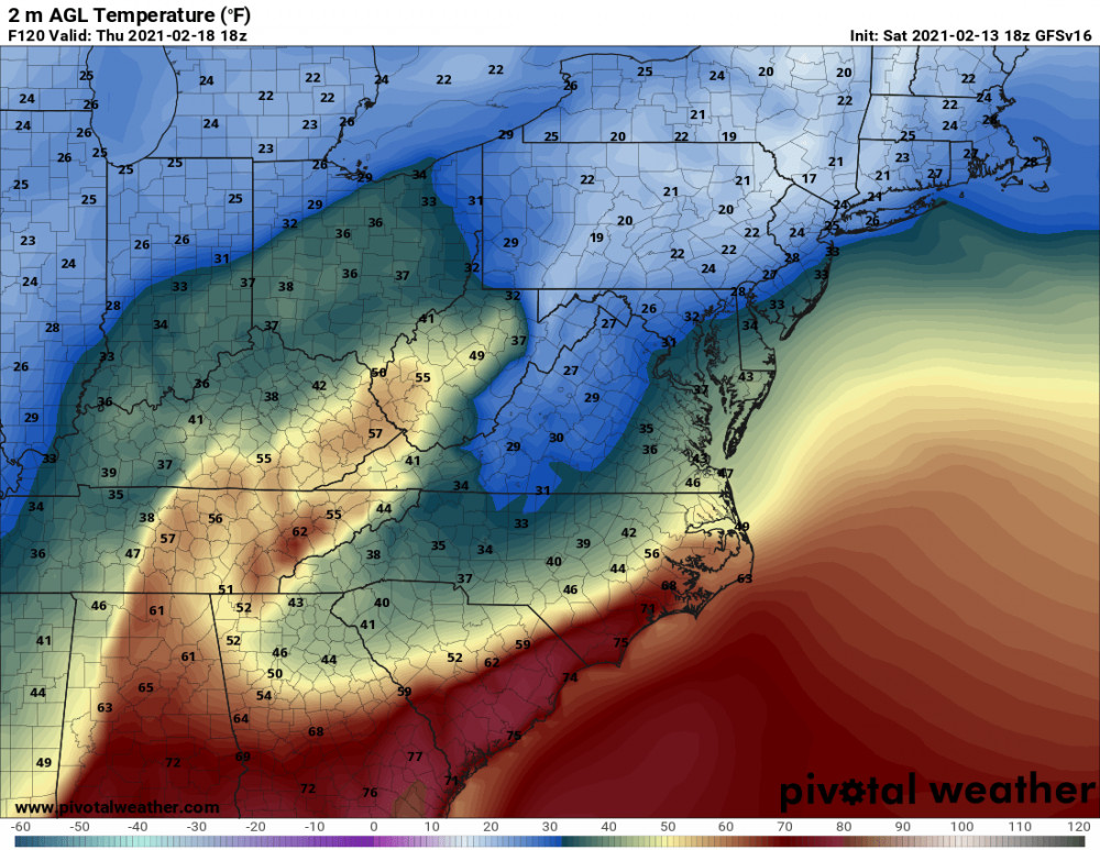
-
One more time for those in the back: .02" of freezing rain is a high-impact event if it's in the 20's and has been for hours leading up the event. That said, there is a clear signal in the CAMs, the parent NAM, the GFS para, and the 18z GFS for sleet at the start for most of the area except for southern MD where it's all ice. Having a coating of sleet first would certainly lessen the impact of freezing rain on surfaces, although I still think that it's going to be unpleasant walking or driving tomorrow and tomorrow night.
- 891 replies
-
- 10
-

-