high risk
-
Posts
3,282 -
Joined
-
Last visited
Content Type
Profiles
Blogs
Forums
American Weather
Media Demo
Store
Gallery
Everything posted by high risk
-
Fair point. I think I'm at close to my breaking point because of Weather53's crusade against NWP.... Honestly yes. The NAM is colder than the GFS which is notoriously crappy with low-level temperature profiles, and the NAM (in conjunction with the HRRR and some other meso models) is telling me that if I'm north of the Beltway tomorrow evening, I have a decent shot to see a modest accumulation of snow. I personally rarely look at the 12 km version of the NAM, because the NAM nest is a much better model, and I think that is a good strategy here this evening with the 00z cycle.
-
Ok, that was my snarky answer. The better answer builds on that a little more. It's still one of the best models for handling shallow cold air masses and things like terrain-induced wind storms in the west and fog. Ultimately, the NAM nest is a way better model, but it's driven by the 12 km NAM, so that's another reason to keep running it. Ultimately, the NAM nest and parent are frozen (no more development is being done on them) and will likely be retired in ~3 years.
-
Because there is way more to judge it by than whether it's too cold and wet for DC area mixed precip events.
-
Knock 'yerself out.
-
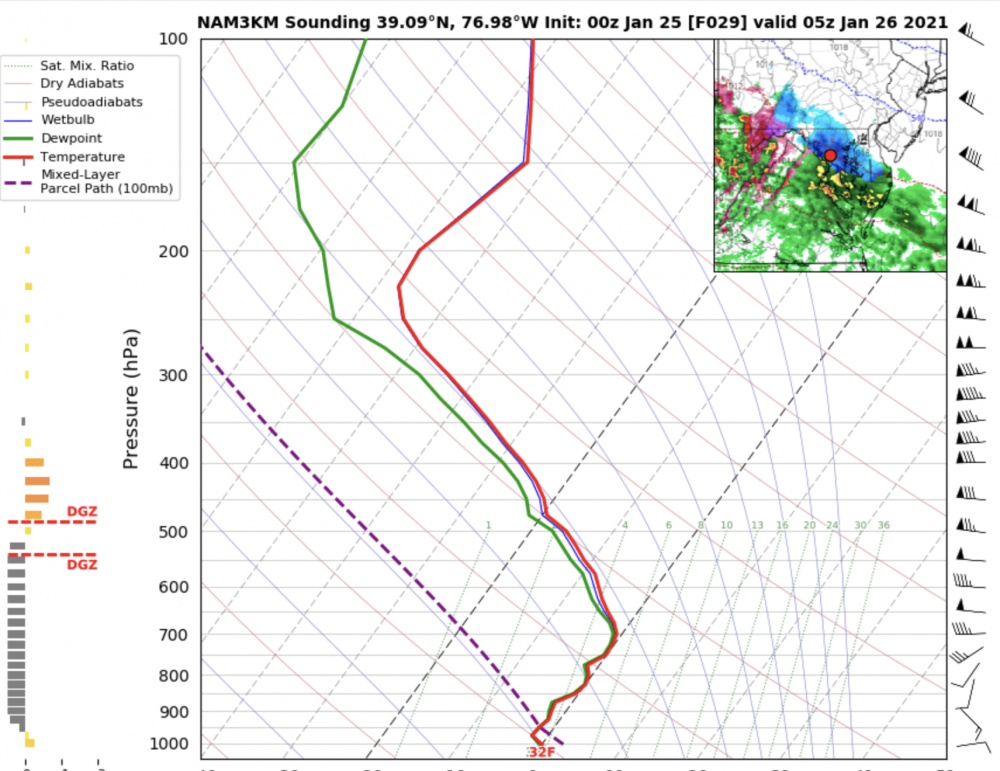
Just to add some actual science to justify tossing the parent NAM, rather than dismissing it by "it's the NAM"..... - the NAM parent is on an island right now with heavy precip extending through the DC metro area. All of the other guidance has jumped ship on higher liquid totals, including the NAM nest. - thermal profiles, while still snow in the NAM forecast, have zero margin for error. It's shown nicely in the NAM nest, which also has snow for much of the area, but has more realistic QPF: Multiple levels are pretty much right at 0C, so it wouldn't take much to turn that into sleet. Ultimately, I do think that those of us north of the Beltway have a shot at an inch or maybe two (for some lucky folks), and that is supported by several CAMs this evening.
-
Fair enough. I'm still hopeful of an inch at the start here in Howard County, but I'm far from confident.
-
Two notes: 1) Anyone showing a 10:1 map for event like this should have his/her account locked for a month. Sleet and snow are tallied together in the model output field used to make the 10:1 images, so they will automatically inflate when you have a mixed event. Tropical Tidbits has the Ferrier method and the accumulated snow depth change, and Pivotal has the Kuchera. Plausible and reasonable alternatives exist. 2) The 18z NAM nest is noticeably warmer with the 2m temps. It gets the entire area above freezing Monday afternoon, and it barely gets below freezing anywhere (including the Shenandoah Valley) Monday night - not the recipe for a high impact ice storm. The HRRR, though, still suggests a slightly bigger temperature drop for areas well north and west of the cities Monday night.
-

January Storm Term Threat Discussions (Day 3 - Day 7)
high risk replied to WxUSAF's topic in Mid Atlantic
That map includes a modest contribution from the Monday event. -
January Storm Term Threat Discussions (Day 3 - Day 7)
high risk replied to WxUSAF's topic in Mid Atlantic
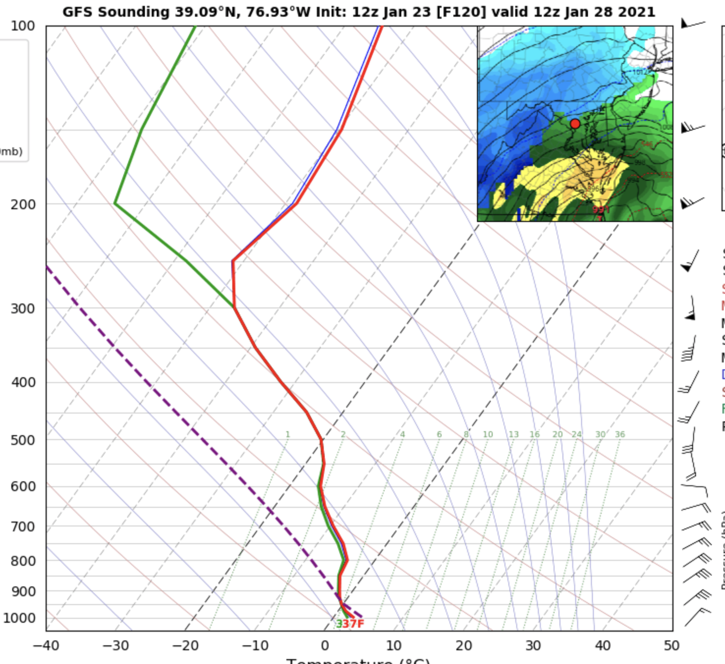
I don't want to discount the lack of low-level cold air, and I suppose that struggling to cool off at the surface even with a really nice synoptic setup is possible, but the GFS is known for poor handling of thermal profiles in winter events, and this forecast sounding looks really goofy to me: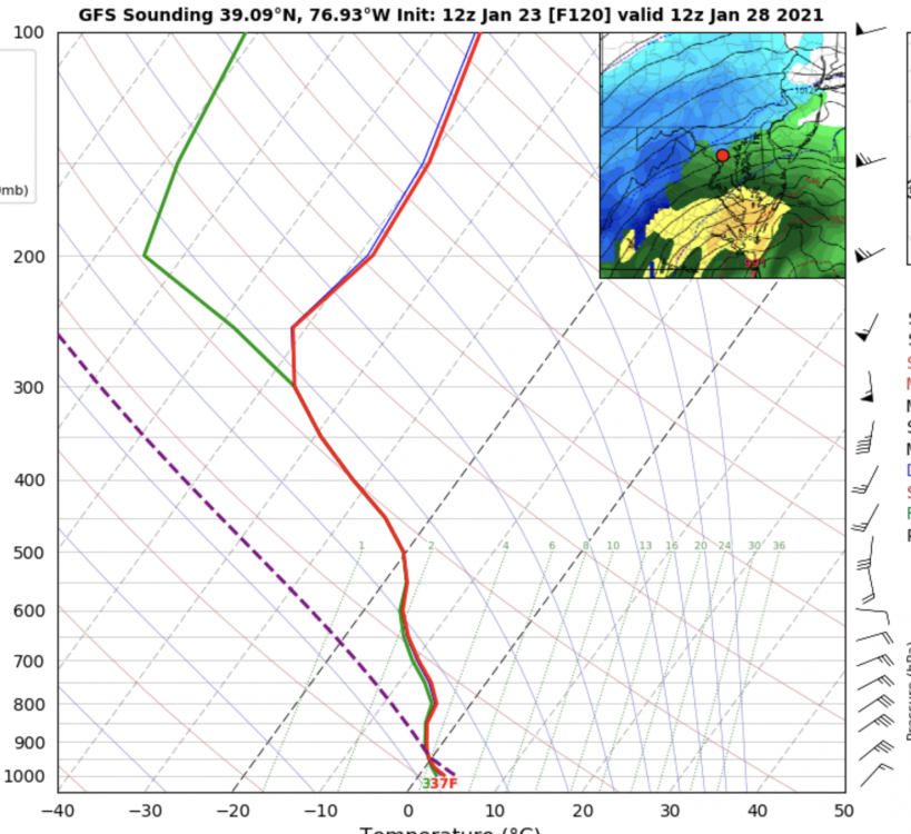
-
Nice front end thump on the Euro for those of us north of the DC Beltway, but there is a very sharp cutoff on the precip for the northeastern part of this forum.
-
Remember that any freezing rain accumulation map is simply tallying rain falling with a sfc temp at or below 32; it is NOT a measure of how much ice will accrete on surfaces. Looking at the NAM and NAM nest, the temperature during Monday stays at or just above freezing before the precip arrives and then drops to or just below freezing after the precip arrives. This usually is not a recipe for significant ice accumulation on roads, sidewalks, etc.... although it can accumulate on trees in that scenario. The only place in the NAM where sfc temps fall a few degrees below freezing is far northern MD.
-
January Storm Term Threat Discussions (Day 3 - Day 7)
high risk replied to WxUSAF's topic in Mid Atlantic
Maybe? If, say, the GFS badly initialized the wave off of the west coast at 18z yesterday, it *could* take a few cycles to undo the damage. For the 00z cycle, it would start with the specification of the wave from the 18z 6h forecast (the first guess). If there is new data where that feature resides at 00z, it will take that into account, but it will probably only adjust the first guess partially towards the new obs there. Then the 06z cycle will adjust further. It depends how much data is available where the feature is and how different it is from the first guess. A famous example is with the NWP failures with the 2000 blizzard. On the morning before the blizzard, the Peachtree City, GA raob had big wind speeds up at jet level, as a huge jet streak rotated through the trough and helped it go negative tilt. The first guess value of the jet level wind speed over GA was about 40 (I can't remember the number) knots lower than the ob, and the models all treated the ob as garbage and pretty much didn't adjust the wind speed there at all. -
January Storm Term Threat Discussions (Day 3 - Day 7)
high risk replied to WxUSAF's topic in Mid Atlantic
Both are true. Yes, the GFS ingests new data for every cycle, but you have to use something as the first guess, and that is the 6-hr forecast from the previous GFS cycle. You can't just insert obs onto a blank slate - there have to be initial values for all prognostic fields at all grid point at all levels, and you adjust those initial values based on the observations to get a solution that is balanced. You can't just use blunt force with a data observation and try to just perform straight interpolation of its value in the horizontal and vertical. -
January Storm Term Threat Discussions (Day 3 - Day 7)
high risk replied to WxUSAF's topic in Mid Atlantic
FWIW, one of the findings during the GFSv16 evaluation was that it handled cold air damming better than v15, possibly due to having more vertical levels. It still won't be nearly as good as the NAM nest, which in my opinion handles damming the best of the models (and sometimes even overdoes it), but once synoptic disagreement is removed, I'd favor the v16 profiles over v15. -
done! NAM3 in particular looks much better for later Saturday afternoon.
-
That's a good catch. It's not as blatant on the NAM3 and the Hi-Res Windows, but even the older cycles of those models clearly show a bit of a southerly component to the winds tomorrow that is absent in the 12z cycle.
-
12z guidance pretty much all took a pretty big step back in terms of coverage of convective rain/snow/graupel showers Saturday afternoon. It's not obvious why, but they all seemed to pick up on *something* that's hostile to the potential.
-
You're too kind. Easy to make a call on this when you have a strong upper trough axis swinging through with lapse rates like these:
-
Nice signal in the NAM nest for some heavy rain/snow/grapuel showers later Saturday as the trough axis swings through with steep lapse rates.
-
I don't have enough fingers to count the number of dead-wrong statements in this post.
-
There are two machines: one in Orlando and one in Reston. One of them is the production machine, and one is the development machine, but they switch back and forth.
-
https://www.emc.ncep.noaa.gov/users/meg/gfsv16/realtime/gfsximages.html It looks like the original post was indeed referring to an older run, but the latest run does have a coastal around the 4th (although it's not a snowstorm, verbatim.)
-
Yep. Big upgrade in early December. https://www.emc.ncep.noaa.gov/users/meg/rapv5_hrrrv4/
-
Yeah, that's fair. It just feels like LWX likes to warn on these things a lot, and the false alarm rate is super high. For this event, I'd rather wait for a report to come in before pulling the trigger, although it's easy for me to say that without my neck on the line.
-
I'm struggling to understand the severe warning, as while that's an impressive feature on radar, it shouldn't be surface-based and therefore unable to get the winds to the ground. But I'm prepared to be wrong....