high risk
-
Posts
3,184 -
Joined
-
Last visited
Content Type
Profiles
Blogs
Forums
American Weather
Media Demo
Store
Gallery
Everything posted by high risk
-

2020 Mid-Atlantic Severe Weather - General Thread
high risk replied to Kmlwx's topic in Mid Atlantic
actually, the deep layer shear needed for an organized severe threat is overall lacking today, which explains the lack of a slight risk. that said, I do think we'll see a few isolated severe warnings later today. -
2020 Mid-Atlantic Severe Weather - General Thread
high risk replied to Kmlwx's topic in Mid Atlantic
Watching the 5th good cell today miss me by a couple of miles. Still stuck at a trace. -
2020 Mid-Atlantic Severe Weather - General Thread
high risk replied to Kmlwx's topic in Mid Atlantic
Yeah, this is comedy watching the whiffs here today. HRRR still says I get soaked in a few hours. Debating whether to water the garden..... -
2020 Mid-Atlantic Severe Weather - General Thread
high risk replied to Kmlwx's topic in Mid Atlantic
Exact same situation here just down the road. I rarely get pissed off at the weather. Right now, I'm really pissed off at the weather. -
2020 Mid-Atlantic Severe Weather - General Thread
high risk replied to Kmlwx's topic in Mid Atlantic
looking out my window here in Howard County, it looks like the atmosphere is trying to initiate locally -
2020 Mid-Atlantic Severe Weather - General Thread
high risk replied to Kmlwx's topic in Mid Atlantic
really need some patience. The CAMs were not forecasting an early show here. It will take time for the PA/NJ complex outflow to surge west and southwest, with development building along it back into northeast MD. There is still a legit question of whether there will be decent coverage in the DC/Baltimore corridor, but IF it happens, it won't be for several hours (and could even be an evening show). -
2020 Mid-Atlantic Severe Weather - General Thread
high risk replied to Kmlwx's topic in Mid Atlantic
No doubt that the eastern shore is the best place to be for organized SVR later today. For those west of the bay, we need the outflow to surge further west. It's worth noting that both the NAM nest and HRRR don't have too many storms in the DC area, as they both mix out the dew points a bit this afternoon. (HRRR is most aggressive.) Some of the other CAMs (the ARW2 of particular note) do not mix out the low-level moisture as much, as they have more coverage of storms west of the bay. -
2020 Mid-Atlantic Severe Weather - General Thread
high risk replied to Kmlwx's topic in Mid Atlantic
12z NAM nest and HRRR both develop storms Saturday in the local area. Instability is limited, and shear is marginal, but there will be a lot of downdraft cape. Personally, I'm not very enthused, because the low level air will be so dry, but I'm ok with the MRGL. Sunday could be good if we lose the ugly warm mid-level temperatures being progged. -
2020 Mid-Atlantic Severe Weather - General Thread
high risk replied to Kmlwx's topic in Mid Atlantic
The one thing we had yesterday that we hadn't had here in a while was good flow aloft on a storm day. We had about 90 kt at jet level Thursday afternoon. -
2020 Mid-Atlantic Severe Weather - General Thread
high risk replied to Kmlwx's topic in Mid Atlantic
today definitely has sneaky potential. as noted by LWX, low level shear is miserable, but deep layer shear is really good, and there is also a fair amount of downdraft cape. I'd say now that while the best threat is definitely south of DC, where the better instability will reside, I'd say "I-70 and points south" for the threat, as the HRRR has definitely trended further north with good reflectivity signals since LWX wrote that discussion. -
2020 Mid-Atlantic Severe Weather - General Thread
high risk replied to Kmlwx's topic in Mid Atlantic
mesoanalysis currently shows 3000+ sfc-based cape for much of the region.... that said, most of the CAMs are not as enthusiastic as they were yesterday and seem to favor locations north and northwest of DC -
2020 Mid-Atlantic Severe Weather - General Thread
high risk replied to Kmlwx's topic in Mid Atlantic
small hail now -
2020 Mid-Atlantic Severe Weather - General Thread
high risk replied to Kmlwx's topic in Mid Atlantic
winds got really close to severe limits here in southern Howard County . -
2020 Mid-Atlantic Severe Weather - General Thread
high risk replied to Kmlwx's topic in Mid Atlantic
Yeah, documentation needs to be updated, and nothing is finalized yet until it can be demonstrated that it's stable, but it's not going to be implemented any time soon. -
2020 Mid-Atlantic Severe Weather - General Thread
high risk replied to Kmlwx's topic in Mid Atlantic
yes, it crashed multiple times during its final stability test, so more testing is required. -
2020 Mid-Atlantic Severe Weather - General Thread
high risk replied to Kmlwx's topic in Mid Atlantic
nope. likely delayed until late fall. The recent problems, however, explain why no data is currently available. -
2020 Mid-Atlantic Severe Weather - General Thread
high risk replied to Kmlwx's topic in Mid Atlantic
Agreed, although tomorrow is interesting, because while the deep layer shear is still weak, there is a fair amount of low level shear. Instability is no worry, and there will be a good trigger, so I think it's worth watching. I'm a bit surprised by the MRGL today. Shear is really, really sad, and even the approaching MCV won't boost the mid-level flow much at all. That said, storms will become fairly organized with the approaching lift, and organization always yields the potential for some coldpool development, so a few wind events likely can't be ruled out. -
2020 Mid-Atlantic Severe Weather - General Thread
high risk replied to Kmlwx's topic in Mid Atlantic
Nice research on this! 2008 was an active svr season for sure, but SPC was handing out MDT risks like Halloween candy. This was back before ENH existed, and they used MDT more liberally to try and distinguish from the run-of-the-mill SLGT days. In that respect, adding in the ENH was a very good move, as it allows them to represent those days with a larger coverage of lower end events and save the MDT for days with a decent concentration of higher end events. June 4, 2008 was a legit MDT for us, and it's a day I'll always remember. I guess that June 10 verified as a MDT over upstate New York and New England, although there weren't any high end reports; the MDT here didn't verify. May 31 and June 16 definitely would have worked fine with ENH, had that been an option. -
2020 Mid-Atlantic Severe Weather - General Thread
high risk replied to Kmlwx's topic in Mid Atlantic
hahaha! The bottom line is that with a big trough sitting to our west during a chunk of next week and moving towards the coast, there will be opportunities for severe in the east, with timing and other details obviously impossible to nail at long forecast lengths. -
2020 Mid-Atlantic Severe Weather - General Thread
high risk replied to Kmlwx's topic in Mid Atlantic
Interesting. Seems like the f144 would be the best shot at svr.... In terms of the progged 500 maps, you have to get excited when you see the day 5 maps showing an impressive trough to our west. The problem is that instead of it overspreading the mid-Atlantic, most guidance either lifts it to the northeast, weakens it, or both. As a result, the progged height falls over our area are really meh in the GFS, GEFS, and Euro ensemble. The deterministic Euro, though, is better and would imply svr chances here on day 6. -
2020 Mid-Atlantic Severe Weather - General Thread
high risk replied to Kmlwx's topic in Mid Atlantic
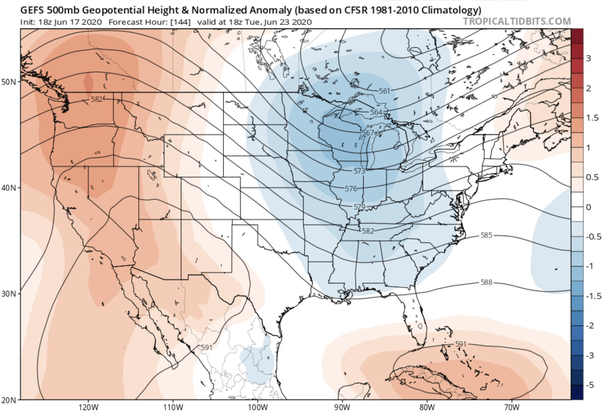
Trying to make some sense of the CIPS lighting up. It's based off of the GEFS, and some of the recent GEFS means for next week look healthy. I grabbed the 18z (the analog was from the 00z cycle, but the 18z 500 map is arguably a bit better....). Anyhow, this is a great look at 500 mb, but of note, neither the Euro ops or ensemble looks anything close to this amplified.
-
2020 Mid-Atlantic Severe Weather - General Thread
high risk replied to Kmlwx's topic in Mid Atlantic
gotcha. and yeah, the 12z guidance seems to be moving the heaviest rain south - we'll see if that's a blip or a legit trend. Either way, the flooding threat will probably be there for some (i.e. lots of rain adding up over a multi-day period); whether it's a flash flood threat will depend upon whether we can get some clearing and heating near the upper low for convection. Right now, it just looks cloudy and cool. -
2020 Mid-Atlantic Severe Weather - General Thread
high risk replied to Kmlwx's topic in Mid Atlantic
And I should note that part of this subforum is still in the game today, with cape and modest deep layer shear still in place. The CAMs show the threat as mostly DC and points south and east, but I still have a 71 dew point here in southern Howard County, so I'm not totally ready to write things off for those just north of DC either. -
2020 Mid-Atlantic Severe Weather - General Thread
high risk replied to Kmlwx's topic in Mid Atlantic
Since I assume you're referring to severe potential here in the severe thread, there's no severe potential this weekend or anywhere on the horizon. While there could be some convective elements in the Sunday-??? period within the rain, it looks like easterly flow over a deep layer and cool surface temperatures. -
2020 Mid-Atlantic Severe Weather - General Thread
high risk replied to Kmlwx's topic in Mid Atlantic
it's gone now, but it looked to me like there was weak rotation for a few scans