

high risk
-
Posts
3,243 -
Joined
-
Last visited
Content Type
Profiles
Blogs
Forums
American Weather
Media Demo
Store
Gallery
Everything posted by high risk
-

2026 Mid-Atlantic Severe Storm General Discussion
high risk replied to Kmlwx's topic in Mid Atlantic
Early thought is that storms will fire Saturday afternoon along the lee trough in an environment with good shear and at least moderate instability. (The NAM is likely too moist in the low levels, so toss its extreme instability). Severe will definitely be a concern, and the high PW environment may support locally intense rainfall, but the fast storm movement should prevent major flooding concerns. The potential round 2 is highly dependent upon timing. Right now, consensus seems to favor arrival very late in the evening, which leads to significant weakening (and possibly falling completely apart) before arrival. The shear will be increasing further after dark, so severe would be possible, but the timing really needs to speed up to make that happen.- 1,025 replies
-
- 3
-

-

-
- severe
- thunderstorms
- (and 7 more)
-
I was in NYC. Really, really unpleasant, although the smoke nicely kept the temperatures down.
-
I've been here 30 years, and late night MCS event surviving from the Midwest and hitting us good have been really rare as far as I can remember. I can think of lots of MCSs falling apart in the morning hours as they arrive in the early morning, but not many delivering the goods in the warm season. (I can think of several cold season events with intense dynamics, but those were more frontal bands than an MCS.) It's just so difficult, because you need elevated instability to compensate for the surface cooling, and we so rarely get the big lapse rates.
-
One thing that makes it so difficult to even distribute summer rain here in the east is the inability to have nighttime MCC events. Over the Plains, you can easily put down 1-2" over a large area with one of those systems, but we so rarely get EMLs here that MCCs can't survive the trip east.
-
2026 Mid-Atlantic Severe Storm General Discussion
high risk replied to Kmlwx's topic in Mid Atlantic
The rare Day 7 SPC outlook for our area!- 1,025 replies
-
- 4
-
-

-
- severe
- thunderstorms
- (and 7 more)
-
Yeah, towers went up along the northward-moving boundary but failed. Something is hostile to development, as shown by the complete collapse of the storms moving south out of PA
-
Maybe, but right now, I’m going to need some convincing that WPC was justified in issuing an MPD for our area
-
Visually from Howard County, cells are trying to go up on that outflow boundary moving north out of DC
-
2026 Mid-Atlantic Severe Storm General Discussion
high risk replied to Kmlwx's topic in Mid Atlantic
This has all of the makings of a "pity MD" day. -
And south and north too.
-
Some signal in guidance for a few late night / early morning cells, with higher chances to the east.
-
2026 Mid-Atlantic Severe Storm General Discussion
high risk replied to Kmlwx's topic in Mid Atlantic
I think it's justified. Lapse rates and instability are modest, but shear is workable, and convection should be organized and timed well for our area. CAMs all look pretty good. Friday has some potential too.- 1,025 replies
-
- 4
-
-
- severe
- thunderstorms
- (and 7 more)
-
Not really sure where discussion of today's weather should go, but there is a clear consensus that today's rain/storm threat will primarily be an after dark show
-
At a time when most storms are ramping down, the cell near Manassas exploded, seemingly aided by a cell merger. Major downburst signal.
-
Initiation ahead of schedule in the local area. Expecting an MD from SPC soon.
-
Yeah, the HRRR develops storms in that general vicinity. NAM Nest develops convection over northern VA
-
They evolve differently, but the HRRR and NAM Nest both like the I-95 corridor in MD around or just after sunset.
-
If today happens, it's going to be a late show.
-
As others have alluded to, the lower dew points yesterday probably led to so much downdraft cape that the damaging winds superseded the heavy rainfall threat. With higher dews today, the HRRR in particular suggests a greater heavy rain threat, although it delays initiation later than several other cams.
-
2026 Mid-Atlantic Severe Storm General Discussion
high risk replied to Kmlwx's topic in Mid Atlantic
Impressive number of reports today in the Mid-Atlantic, but a noticeable hole over northern Virginia.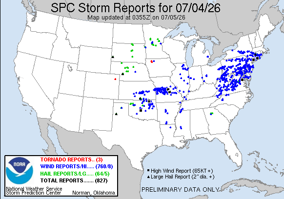
- 1,025 replies
-
- 4
-
-

-
- severe
- thunderstorms
- (and 7 more)
-
Yeah, I have doubts too, but we need to let this play out. Some initiation now in Montgomery County. Outflow boundaries could explode in this environment.
-
WPC heavy rainfall discussion suggests that experimental WoFS guidance really lights up the 95 corridor over the next few hours.
-
If we're not going to use the severe thread, we should rename this thread to include the storm threat.
-
2026 Mid-Atlantic Severe Storm General Discussion
high risk replied to Kmlwx's topic in Mid Atlantic
Dew points have legitimately crashed. That doesn’t seem to be hindering storm development to the west, and irs probably increasing the wind threat (with larger downdraft cape), but it *might* limit coverage a bit.- 1,025 replies
-
- 4
-
-
- severe
- thunderstorms
- (and 7 more)
-
2026 Mid-Atlantic Severe Storm General Discussion
high risk replied to Kmlwx's topic in Mid Atlantic
The lower dew points give me pause for sure, but I feel better seeing that even the HRRR, which overmixes the crap out of our area this afternoon, initiates a modest coverage of storms locally.