high risk
-
Posts
3,241 -
Joined
-
Last visited
Content Type
Profiles
Blogs
Forums
American Weather
Media Demo
Store
Gallery
Everything posted by high risk
-
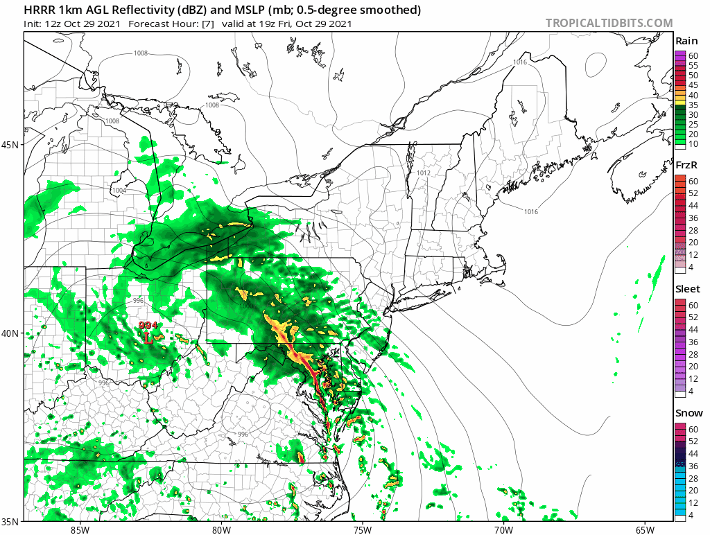
1.61" at BWI in the past 3 hours. Over 2" for the event.
-
The models have been indicating that some scattered convection would develop in the dry slot, where some weak instability would develop. Fortunately, the good low-level shear is rapidly moving away to the northeast.
-
There is a large area of heavy rain with convective elements now affecting the areas just east of DC moving north into Howard Co and the Baltimore area, with more redevelopment further south. I'm not saying that it's going to be a widespread 4-5" event or anything like that, but the totals are really going to add up over the next few hours.
-
But the heaviest convective elements have yet to move through the areas on the east side of the Potomac, and the HRRR (and other CAMs) have been suggesting redevelopment which will keep the rain going for a while, and the latest HRRR runs suggest another 1-2 inches for some. Accordingly, WPC is discussing potential flash flooding in the 2-5pm time frame: https://www.wpc.ncep.noaa.gov/metwatch/metwatch_mpd_multi.php?md=1115&yr=2021
-
The big question is whether the line of forced convection that races northeast through the area this afternoon can mix down the stronger winds just above the surface. It may be too stable to do that (especially on the north side of town), and the best low-level winds will be exiting to the northeast as the line arrives, but if we can overlap just a little bit of instability with the stronger wind fields, it could get really ugly.

-

2021 Mid-Atlantic Severe Weather - General Discussion
high risk replied to Kmlwx's topic in Mid Atlantic
In addition to the coastal flood threat, areas generally south of DC are in a MRGL risk for damaging convective wind gusts Friday afternoon. Several models are now showing a little bit of sfc-based instability Friday afternoon, which could allow some of the faster wind speeds just above the surface to mix down. I'll note that 1) a few CAMs develop instability even further to the north than currently indicated in the MRGL region implying a more widespread threat but 2) a lot of the stronger wind speeds above the surface will move off to the northeast before the instability develops which implies an overall lesser threat -
2021 Mid-Atlantic Severe Weather - General Discussion
high risk replied to Kmlwx's topic in Mid Atlantic
Good point, and the HRRR is still struggling to initialize them. The only guidance that explicitly showed this was the ARW2. Some of the other guidance has shown cells developing later this afternoon south of DC and moving north, so I think that these solutions correctly captured the northward-moving forcing mechanism but struggled to initiate storms much earlier and much further south. -
2021 Mid-Atlantic Severe Weather - General Discussion
high risk replied to Kmlwx's topic in Mid Atlantic
Dew points have been lowering at all 3 airports over the past few hours (likely due to mixing), which seems to match what the HRRR has been forecasting. -
2021 Mid-Atlantic Severe Weather - General Discussion
high risk replied to Kmlwx's topic in Mid Atlantic
HRRR seems to have a good handle on the environment. It's going for roughly 80/58 by mid-afternoon which seems reasonable. NAM Nest is too cool - it really raises the dew points later this afternoon, and I'm not sure that's going to be right. -
2021 Mid-Atlantic Severe Weather - General Discussion
high risk replied to Kmlwx's topic in Mid Atlantic
Yeah, the signal for this started showing up yesterday, and even the Hi-Res Windows are buying in, although they disagree a bit on location and timing. (The HiResW FV3 initiates the lead cells notably further north.) Seems like several cells will race from south to north out ahead of the more organized line rolling east. Still unclear how much instability will be available: the HRRR is much warmer (but drier), while the NAM Nest is more moist (but cooler). Perhaps there is a temperature/moisture "sweet spot" in there that could increase the potential for some hail and wind. -
seems to be some growing potential for the Tuesday deep offshore low to loop back to the south/southwest, which opens the door to rain rotating back into our area during the afternoon, likely accompanied by some stiff winds. This is after the likelihood of heavy convective rains Monday evening. And with the potential for a big soaker Friday/Saturday, this will be a much-needed wet week.
-
2021 Mid-Atlantic Severe Weather - General Discussion
high risk replied to Kmlwx's topic in Mid Atlantic
This post didn't age well, as the timing now appears to be much faster. If we toss the anemic, outlier NAM Nest solution, a large area of convection should be approaching from the southwest in the early evening with perhaps a few lead cells out ahead racing south to north. Deep layer shear is good but is mainly due to very fast winds at the higher levels; the combination of weaker shear in lower levels and limited instability will likely mitigate the threat in the DC/Baltimore area, although an earlier arrival would open the door to a slightly higher threat. -
2021 Mid-Atlantic Severe Weather - General Discussion
high risk replied to Kmlwx's topic in Mid Atlantic
SLGT for the southwest part of the area and MRGL for the rest. The question will be how warm it can stay after dark. Clouds and southerly winds should keep temps up through the evening and overnight hours, but it will still be cooling, and instability will be limited. The better threat is definitely well west and southwest of our area, but a line of storms (or heavy showers) well after dark with some wind potential is probably worth the threats SPC has assigned. -
2021 Mid-Atlantic Severe Weather - General Discussion
high risk replied to Kmlwx's topic in Mid Atlantic
Nothing has really changed. Instability is going to limit the severe threat, but a forced line of convection will sweep across the area during the early to mid afternoon hours on Saturday. Lightning threat is limited, but I would still not be surprised if some healthy gusts accompany the line. -
2021 Mid-Atlantic Severe Weather - General Discussion
high risk replied to Kmlwx's topic in Mid Atlantic
Certainly possible. Looks likely that there will be a line of forced convection along the cold front in the late afternoon. Deep layer shear will be robust, but as you note, the instability is the question mark. -
Fabulous lightning show to my north-northwest. It's not frequent, but it's super bright and looks amazing in the drier air with stars out.
-
Yeah, I'm not sure what to make of this. The HRRR continues to be very emphatic about an active evening, but it doesn't have any of these early stuff. The current evolution seems to match more of some of the other CAMs which had an earlier, more scattered event.
-
My lawn could use a drink too... hope that we all cash in. SPC has put our region in a MRGL risk for SVR, which is consistent with the idea of more organized convection occurring.
-
There isn't much agreement in the timing, but the morning suite of CAMs suggests a really good chance of moderate or even fairly widespread convection over central and northern Maryland either during the dinner or early evening hours.
-
We've gone from multiple inches of rain for the week ahead to 0.5-0.75" on the WPC maps. To its credit, the GFS was never really on board with the Euro's big event.
-
2021 Mid-Atlantic Severe Weather - General Discussion
high risk replied to Kmlwx's topic in Mid Atlantic
Coverage will be limited, but there should in theory still be a few storms on the front over the next 4-5 hours. And any of those storms that are able to sustain strong updrafts could produce some severe winds or hail. I'm not super excited about this event, but I'm also not ready to say that it's over. -
2021 Mid-Atlantic Severe Weather - General Discussion
high risk replied to Kmlwx's topic in Mid Atlantic
Those "good" runs earlier this morning had these showers on the north side of DC during the late morning, so I'm not terribly worried. That said, don't look at the 12z NAM Nest. -
2021 Mid-Atlantic Severe Weather - General Discussion
high risk replied to Kmlwx's topic in Mid Atlantic
I'd generally agree, but a complicating factor is that no guidance has a very good handle right now on the strengthening convection over northeast WV and far western MD. Curious to see whether that has any influence on the evolution today. -
2021 Mid-Atlantic Severe Weather - General Discussion
high risk replied to Kmlwx's topic in Mid Atlantic
Agreed with all of this. While I think that there are several mitigating factors (most notably the potential for subsidence behind the morning wave), I will note that 1) the 6z NAM nest for whatever reason tends to go weak on convection 2) I usually take it as a very positive sign when a morning, elevated MCS somewhere in the Mid-Atlantic is producing lightning. That's a great sign that we have steeper than usual lapse rates. -
2021 Mid-Atlantic Severe Weather - General Discussion
high risk replied to Kmlwx's topic in Mid Atlantic
Might end up with a small SLGT risk area at some point tomorrow, but right now, there are too many questions on magnitude of instability and location and coverage of storms to justify the upgrade, IMHO.