Yanksfan
-
Posts
1,261 -
Joined
-
Last visited
Content Type
Profiles
Blogs
Forums
American Weather
Media Demo
Store
Gallery
Everything posted by Yanksfan
-
 They must of seen something that the models have yet to pick up on. A little strange that they didn’t at least wait till the 0z runs come out.
 -
Further east? Just this morning we were worried about possible mixing issues! I need a new hobby.
-
It only goes out to Friday 7am. Storm is still ongoing.
-
Snow maps please.
-
6z RGEM is north.
-
Yet there were continued incremental improvements in the upper levels with less confluence/ stronger WAR. The north creeps may very well continue up until start time.
-
No we don’t necessarily need the Pacific to cooperate to get a snowstorm, but it’s encouraging to see the latest long range guidance showing a much improved PNA. GEFS and EPS are hinting at a possible KU pattern developing at the end of their runs.
-
Does anyone have the latest ENSO forecast graph? At the very least it looks like the Nina has peaked out.
-
I couldn’t care less what it shows. Above normal temps coinciding with above normal snowfall is becoming the new norm. Torch away as long as I get my 40+ inches.
-
This winter like most will come down to the NAO. There are good signs that we will have episodes of blocking which will certainly help our cause, but will it be a dominating force or just brief occurrences? Unfortunately the NAO is a very difficult feature to forecast especially in the long range.
-
I yearn for the winters when I was a kid… pattern flip to cold around Thanksgiving followed by snow chances in December into January. Around mid month comes the dreaded week long January thaw (I like to refer it as halftime), then the 2nd half of winter rolls in with a blockbuster storm for good measure.
-
We better hope so. A strong one and you might as well cancel winter.
-
6 fatalities now reported in NJ. Sad situation.
-
What made 3/5/01 so painful was the big hype of the storm. I’ll never forget the snowfall map Al Roker showing 2-3 feet for the eastern half of NJ, while the western half was 3-4 feet two days before the event! That bust forever changed TV forecasters methods when it comes to a potential major event. They have become much more conservative when it comes to predicting snowfall amounts.
-
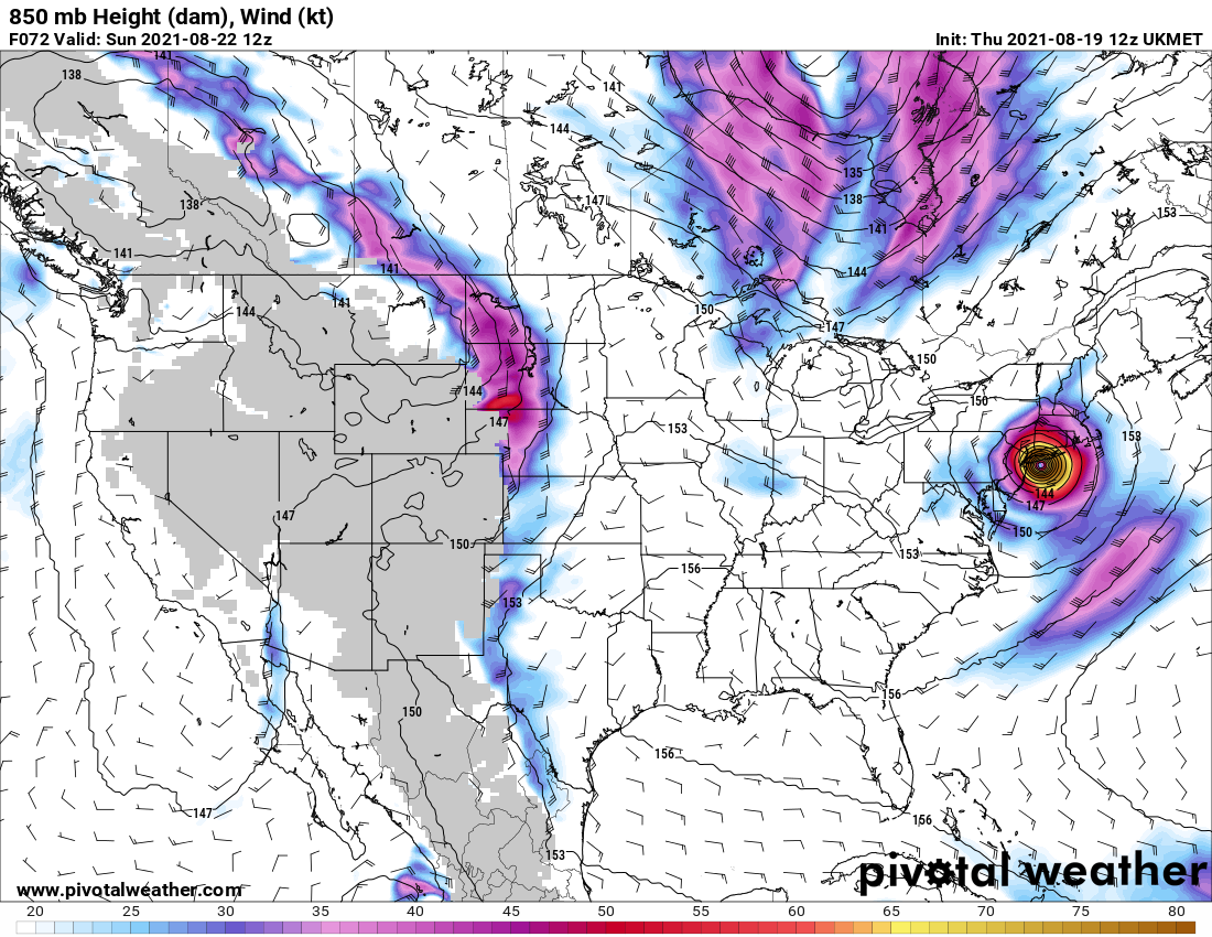
The outflow with Ida is textbook. Won’t be long before it’s upgraded to hurricane status if not already there.
-
I remember seeing an interesting program on tv a couple of years back on global warming. As the earth continues to warm there will come a point where too much fresh water from the melting northern polar cap will mix into the Atlantic thus shutting down the currents and triggering an ice age in the northern half of North America that could last for hundreds of years. So you’re half right. Different cause but in the end the same result.
-
That’s the reason why I despise the summer and relish the cold and snow of winter. Thus my avatar and name.
-
Feb 18-19 long duration manageable snow and ice event
Yanksfan replied to wdrag's topic in New York City Metro
Whether it’s wishcasting or not the radar is exploding down south. I would not be surprised to see a northward shift tomorrow. -
Feb 18-19 long duration manageable snow and ice event
Yanksfan replied to wdrag's topic in New York City Metro
1010 Wins calling for a general 6-10 across the area. The Met mentioned there will be a mix occurring in locations by Friday morning but that is subject to change. -
Don’t look at the GFS thermals. With that track it’s a big snowstorm for all taken verbatim of course.
-
GFS ensembles show 1.5 qpf area wide. Quite impressive for a storm still 5 days away.
- 2,426 replies
-
- 1
-

-
- heavy snow
- ice pellets
- (and 3 more)
-
It’s in the New England forum. It shows 8-12 area wide.
- 2,426 replies
-
- 1
-
-
- heavy snow
- ice pellets
- (and 3 more)