All Activity
- Past hour
-
These spotter locations for this tornado in Texas at night are wild Sent from my SM-G970U using Tapatalk
-
Did today bust out in the plains? Sent from my SM-G970U using Tapatalk
-
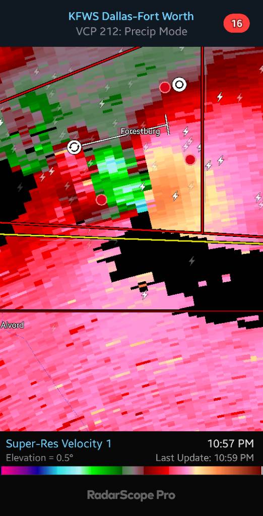
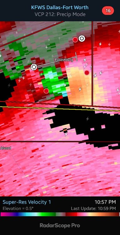
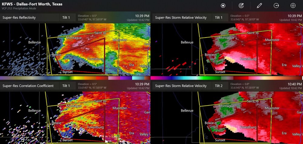
Mean looking storm in Montague county rn Severe Weather Statement National Weather Service Fort Worth TX 952 PM CDT Sat May 25 2024 TXC337-260330- /O.CON.KFWD.TO.W.0048.000000T0000Z-240526T0330Z/ Montague TX- 952 PM CDT Sat May 25 2024 ...A TORNADO WARNING REMAINS IN EFFECT UNTIL 1030 PM CDT FOR SOUTHEASTERN MONTAGUE COUNTY... At 952 PM CDT, a severe thunderstorm capable of producing a tornado was located 9 miles northeast of Sunset, or 12 miles east of Bowie, moving east at 40 mph. Forestburg is in the path of this tornado. HAZARD...Tornado and golf ball size hail. SOURCE...Radar indicated rotation. IMPACT...Flying debris will be dangerous to those caught without shelter. Mobile homes will be damaged or destroyed. Damage to roofs, windows, and vehicles will occur. Tree damage is likely. Locations impacted include... Forestburg. PRECAUTIONARY/PREPAREDNESS ACTIONS... Tornadoes are extremely difficult to see and confirm at night. Do not wait to see or hear the tornado. TAKE COVER NOW! && LAT...LON 3345 9772 3354 9776 3363 9749 3344 9749 TIME...MOT...LOC 0252Z 274DEG 34KT 3351 9763 TORNADO...RADAR INDICATED MAX HAIL SIZE...1.75 IN $$ Prater
-

May 2024 Discussion - Welcome to Severe Season!!!!
mreaves replied to weatherwiz's topic in New England
I thought about you and Diane when we drove through. Big craft fair in N. Conway. -
Great to hear. We really killed it here with a complete 0.1" downpour. Next system looks a bit better but honestly I like the small systems for my area as these bigger ones tend to split particularly for MBY. Might head out to west side of the state tomorrow afternoon, as I think it will do better.
-
It is quite hot here. Today we hit 99. Dews were as high as 79. At times, heat indices were up in the low 110s. This is kind of early for this kind of heat/ humidity.
-
Here's a non-confirmed tornado warning in North Texas, but not too close to Dallas/Fort Worth area.
-

2024-2025 La Nina
Stormchaserchuck1 replied to George001's topic in Weather Forecasting and Discussion
La Nina is coming in real nicely on CDC daily composites. Starting east-based like the last few we've had since 2000. https://freeimage.host/i/JLxCQov -
It will definitely be better than this past ratter of a winter.
-
More attachment space
Stormchaserchuck1 replied to Stormchaserchuck1's topic in Forum Information & Help
Test [url=https://freeimage.host/i/JLxCQov][img]https://iili.io/JLxCQov.md.gif[/img][/url] [url=https://freeimage.host/i/JLxCQov][img]https://iili.io/JLxCQov.th.gif[/img][/url] Edit: I don't know, that's freeimagehost. Imagebb use to link with picture, but doesn't anymore. -
Cold summers following El Niño winters are just very rare like 1992 (due to the 1991 Pinatubo eruption), 2003, 1969, or 1958. None of those cold summers after El Niño winters were followed by a La Niña winter. Each of those cold summers were either followed by a Neutral winter or a 2nd-year El Niño winter.
-
Pouring now with a bit of thunder and lightning
-
Another thunderstorm here late this afternoon. Only light rainfall (~0.10”).
-
-

May 2024 Discussion - Welcome to Severe Season!!!!
alex replied to weatherwiz's topic in New England
Went right by me! 33F for a low this morning but no damage to plants -
A few isolated cells have popped up over somerset
- Today
-
Records: Highs: EWR: 93 (1991) NYC: 95 (1880) LGA: 95 (2007) JFK: 91 (1991) Lows: EWR: 42 (1956) NYC: 41 (1925) LGA: 44 (1967) JFK: 41 (1967) Historical: 1896: An estimated F5 tornado hit Oakwood, Ortonville, and Thomas, Michigan. Forty-seven people were killed, and 100 were injured. Trees were debarked "even to the twigs, as though done by the careful hand of an experienced artisan." Parts of houses were found up to 12 miles away. 1917 - A tornado ripped through southeast Kansas, traveling 65 mph. The average speed was a record for any tornado. (The Weather Channel) 1955 - Two tornadoes struck the town of Blackwell, OK, within a few minutes time during the late evening. The tornadoes killed 18 persons and injured more than 500 others. Early the next morning a tornado virtually obliterated the small community of Udall KS killing 80 persons and injuring 270 persons. More than half the persons in the community were killed or injured by the tornado. (David Ludlum) (The Weather Channel) 1975: On Raccoon Lake, Indiana, lightning struck the motor of a speedboat and traveled up the control wires, killing the driver. The 38-year-old man was knocked into the water by the bolt. His wife and two children, also in the boat, were not injured. 1987 - Thunderstorms spawned fifteen tornadoes in West Texas. One thunderstorm spawned a powerful tornado near Gruver, TX, along with golf ball size hail and 75 mph winds. A man on a boat on Lake Bistineau in northwest Louisiana was struck and killed by lightning, while the other three persons in the boat were unharmed. The man reportedly stood up in the boat and asked to be struck by lightning. (The National Weather Summary) (Storm Data) 1988 - Unseasonably cool weather prevailed in the Upper Midwest. Marquette, MI, reported a record low of 26 degrees. Thunderstorms in the north central U.S. produced wind gusts to 62 mph at Idaho Falls, ID, and produced 4 inches of rain in less than four hours in northern Buffalo County. (The National Weather Summary) (Storm Data) 1989 - Thunderstorms developing ahead of a strong cold front produced severe weather from Oklahoma to Ohio through the day and night. Thunderstorms spawned nine tornadoes, and there were 155 reports of large hail and damaging winds. Hail three and a half inches in diameter was reported at Dittmer, MO, and thunderstorm winds gusting to 90 MPH caused twenty million dollars damage at Rockville IN. (The National Weather Summary) (Storm Data) 1990 - Evening thunderstorms spawned four tornadoes in Kansas and Missouri, and there were three dozen reports of large hail or damaging winds. Thunderstorms produced hail two inches in diameter at Cole Camp, and wind gusts to 72 mph at Rosebud. Heavy thunderstorm rains produced flash flooding in central Missouri. Flood waters swept through Washington State Park southwest of Saint Louis, and nearly one hundred persons had to be rescued from water as much as twenty feet deep. The flood waters swept away a number of vehicles, some were carried as much as four miles away. (The National Weather Summary) (Storm Data) 2008: A rare, large and destructive EF5 tornado created a 43-mile long path across Butler and Black Hawk counties in Iowa. This tornado killed eight people, injured dozens and caused several millions of dollars in damage. The tornado was nearly three-quarters of a mile wide as it moved through the southern end of Parkersburg. A third of the town was affected by devastating damage with nearly 200 homes destroyed. This storm produced the first EF5 tornado in Iowa since 6/13/1976 and only the third EF5 tornado to occur in the United States in the past ten years.
-
SPC likes big winds for us
-
Camp Hill got 0.4". Where I was at in Perry county 2". I swear the mountains must flood for lots of areas in true south central Pennsylvania to get normal rain Sent from my SM-G970U using Tapatalk
-

Texas 2024 Discussion/Observations
Powerball replied to Stx_Thunder's topic in Central/Western States
Provided there's not much cloud cover for once, DFW has a shot at its first 100*F high of the season tomorrow. -
Highs; PHL: 88 TTN: 85 ACY: 84 EWR: 81 NYC: 81 TEB: 81 New Brnswck: 80 LGA: 80 JFK: 77 BLM: 76 ISP: 74
-
I’m didn’t know there was a whole thread! I was positing in DISCOBS. I left Alexandria at 11 pm this night and drove nearly 250 miles round trip. Weather was actually worse in Shenandoah from 1-4 am. It wasn’t until on my way home passing back over the blue ridge that the skies cleared and I saw the aurora over Leesburg. .
-
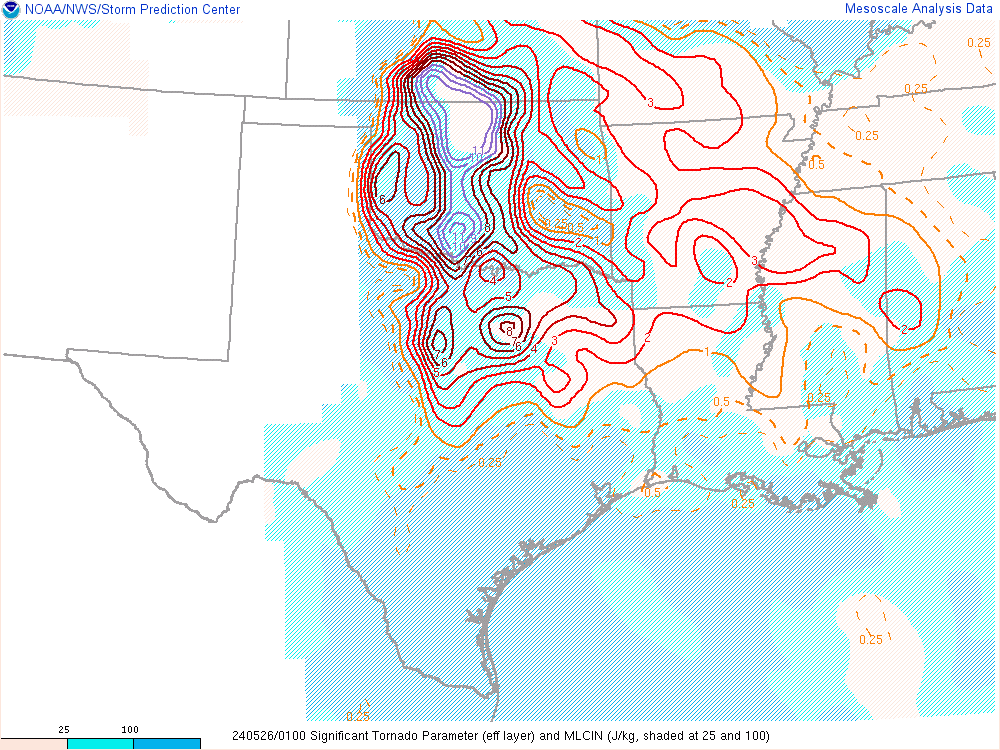
Overturned environment. Big blob of meager low level lapse rates.
-
For those who love the indices, this is spectacular
-
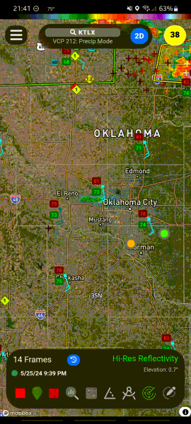
any idea why this cell, among others, are dying as soon as they get into the OKC area?