All Activity
- Past hour
-
Insurance is the big issue for people down here right now. It is all we are hearing about as we visit family. All but one were dropped by their carrier and had to switch to Citizens which is the insurer to last resort re: your wallet is not going to be happy. We have friends in Sarasota whose insurance is over 25K a year including the wind damage option...and their house is under 2000K sq feet. Lots of people, who do not have a mortgage, are chancing it with no insurance. It snows in Jax about every 3-5 years for non accum! Accum is more rare.
-
We were just searching for houses in Hanover 5 years ago and in our price range the highest taxes we saw were under 4K. This was the homestead price or whatever that is called in PA. I did see 6K taxes next Tamaqua, Maybe we did not see any in your zip code/district. But having all real estate and school taxes under 3K was a requirement of our searching.
-
Is 4 months of 90s not enough?
-
Also, why is a solid -NAO like 2010-11 even being given serious consideration based on its rarity in winter since 1979-80?
-
Ended up yesterday with .99". Nice and cool today. Had to wear a jacket this morning as the wind made it feel even colder than the 60 on the thermometer. Currently at 11:40 am it is only 63.
-
The only issues (2) that I have synoptically with 10-11 is the current solar state and the *possible* upcoming Modoki configuration of this La Niña….
-
For starters, I think we can throw out 2010-11 as 2010-11 is not a valid analog because it had a very strong -NAO in Dec and Jan. Also, I agree we can throw out 2020-21 because it also had a -NAO. There’s no good reason based on what we know now as well as what long range models are showing to think that there will be anything even close to a strong -NAO next winter. Moreover, -NAO winters have been few and far between since 1979-80. Only 13% of them since then have had a -NAO averaged out over DJF: 1984-5, 1986-7, 1995-6, 2009-10, 2010-11, and 2020-1. All 6 were within two years of a sunspot cycle minimum and had avg sunspot numbers under 35. Next winter will be active with much higher than 35. Coincidence? I don’t know but I maintain that the chances of a solid -NAO next winter similar to DJ of 2010-11 are very low based on the last 44 winters.
-
We hope
- 926 replies
-
- 1
-

-
- spring
- cool temps
- (and 3 more)
-

2024-2025 La Nina
PhiEaglesfan712 replied to George001's topic in Weather Forecasting and Discussion
For starters, I think we can throw out 1949-50. That one came after several enso neutral seasons (1946-47 is the only one in the previous 5 years that resembled an el nino, but that was very weak and very short). 1949-50 is the last first year la nina that didn't result from an el nino transition. I don't like the 2020-21 analog either. The preceding el nino (which started in 2018) was weak, and 2019-20 was a unicorn season that hovered around 0.4 or 0.5 until it dissipated (this hasn't happened in over 75; the aforementioned 1946-47 comes the closest). 1970-71 and 2007-08 can be okay analogs. The only thing is the el nino of those preceding years was weak. I guess 1970-71 could pass if you consider the first year of the preceding el nino (1968-69) was moderate. This leaves 1998-99 and 2010-11 as the best of the six analogs on the list. I'd replace 1949-50 and 2020-21 with 1973-74 and 1988-89. My list of six best analogs, at this point, would be 1970-71, 1973-74, 1988-89, 1998-99, 2007-08, and 2010-11. -

Central Pa. Spring 2024
Itstrainingtime replied to mahantango#1's topic in Upstate New York/Pennsylvania
Yes - we have extended family members living in Jacksonville, New Smyrna Beach and Kissimmee. We visit on each trip and listen to them and have learned a lot...honestly, if we do make the move it'll likely be to the Jacksonville area. I get my Florida vibes going and we can get home to visit in 12 hours. -
2024 Short/Medium Range Severe Weather Discussion
Radtechwxman replied to Chicago Storm's topic in Lakes/Ohio Valley
Same. Enhanced days are significant weather days so going to have a hatched area definitely for wind and probably tornadoes. Makes 0 sense. -
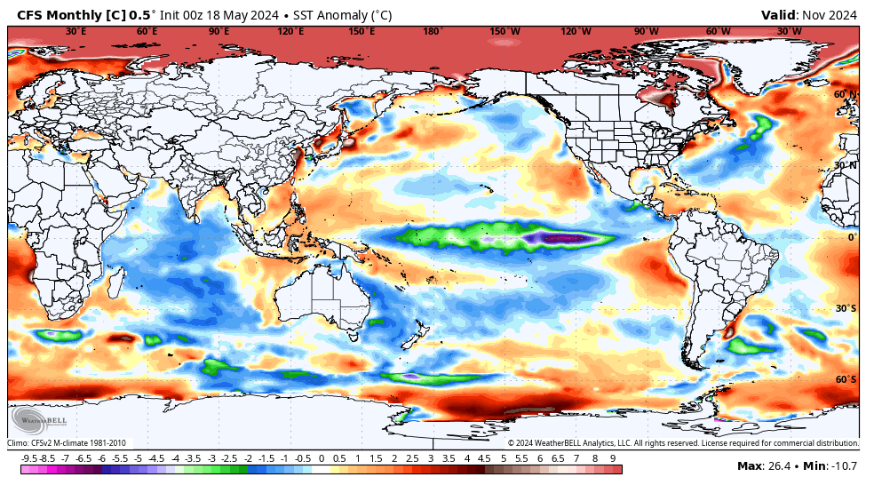
He’s been claiming that these (what I know are very flawed) WB CFS SSTa maps are showing a +PDO, not -PDO. This particular one is ironically showing closer to a neutral PDO (which he isn’t acknowledging and which is still way off from TT CFS, which continues to show solid -PDO). But many of the WB CFS runs have been showing a fake large area of BN in much of the W to CPAC from Hawaii W and NW (just like the fake IO BN) while also showing the warmest NPac anomalies to include a large area off Baja. TT CFS maps have been showing nothing of the sort. And now it looks like WB CFS may be finally starting to correct this BS.
-
I definitely expect to see a couple low 90s
- 926 replies
-
- 3
-
-
- spring
- cool temps
- (and 3 more)
-
To me it still appears that winds will go SW which will allow us to get well up into the 80s. In fact I was probably being a little conservative 2 days ago when I said mid 80s. Now I think we'll be upper 80s to around 90 Tuesday through Thursday.
- 926 replies
-
- 1
-
-
- spring
- cool temps
- (and 3 more)
-

May 2024 Discussion - Welcome to Severe Season!!!!
jbenedet replied to weatherwiz's topic in New England
Not really. It’s May 19. -
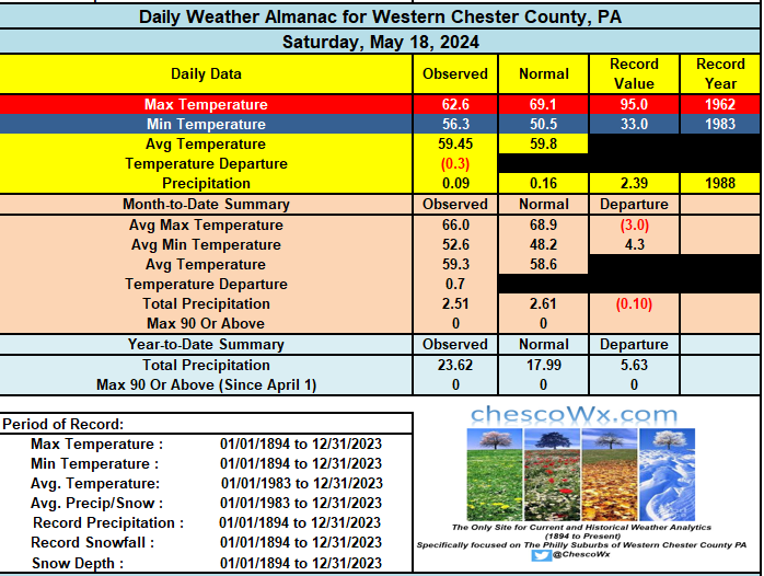
After another 0.09" of rain yesterday here in East Nantmeal we are way above normal rainfall for the year and almost normal so far here in May. Great news for the local farmers! Today should see the sun returning at times with temps not too far from normal in the low to mid 70's. Sun from Monday through Wednesday with temps warming into the low 80's. Shower chances by Thursday before the sun returns with temps about normal for Memorial Day weekend. Records for today across Chester County: High 96 degrees at Phoenixville (1962) of note all 9 reported weather locations on that date in 1962 had highs between 93 and 96 degrees. Record cold was 33 degrees at Kennett Square 2S (2009) / Record rain was the 4.85" that fell in West Chester (1900). All 4 reporting locations that day recorded big rain totals with Phoenixville 4.72" / Coatesville 1SW 3.46" and Kennett Square 2.75"
-

E PA/NJ/DE Spring 2024 OBS/Discussion
ChescoWx replied to Hurricane Agnes's topic in Philadelphia Region
After another 0.09" of rain yesterday here in East Nantmeal we are way above normal rainfall for the year and almost normal so far here in May. Great news for the local farmers! Today should see the sun returning at times with temps not too far from normal in the low to mid 70's. Sun from Monday through Wednesday with temps warming into the low 80's. Shower chances by Thursday before the sun returns with temps about normal for Memorial Day weekend. Records for today across Chester County: High 96 degrees at Phoenixville (1962) of note all 9 reported weather locations on that date in 1962 had highs between 93 and 96 degrees. Record cold was 33 degrees at Kennett Square 2S (2009) / Record rain was the 4.85" that fell in West Chester (1900). All 4 reporting locations that day recorded big rain totals with Phoenixville 4.72" / Coatesville 1SW 3.46" and Kennett Square 2.75"
-

May 2024 Discussion - Welcome to Severe Season!!!!
Torch Tiger replied to weatherwiz's topic in New England
overcast but brightening a bit. Could be worse -
Right. The “cold” in that region of the IO he’s showing corresponds to -IOD, which is actually very likely and will only serve to strengthen the Niña along with the -PDO and -PMM. I guess he doesn’t care that it also shows the -PDO and a central based/Modoki Niña, which contradicts a big part of his analogs but that won’t stop him from using them anyway because they fit his cold and snowy east coast winter agenda, which is why he’s wishcasting high Atlantic ACE as a fallback in case that happens
-
I think that if anything, temperatures will probably over perform this week Tues-Thurs especially Wednesday. WX/PT
- 926 replies
-
- 1
-
-
- spring
- cool temps
- (and 3 more)
-

May 2024 Discussion - Welcome to Severe Season!!!!
SouthCoastMA replied to weatherwiz's topic in New England
50° and drizzle. so much for mowing this weekend -
I agree. We are pulling slowly out of the blocked up pattern of light rain, mist, drizzle, clouds and cool temperatures. Weather this coming week will be exponentially better than last week.
- 926 replies
-
- 1
-
-
- spring
- cool temps
- (and 3 more)
-

May 2024 Discussion - Welcome to Severe Season!!!!
Damage In Tolland replied to weatherwiz's topic in New England
Just bought tomatoes and pepper plants. We plant . 60’s with a peak of sun every now and again. Worlds better than yesterday -
He keeps showing individual runs of WB CFS SSTa prog maps for Nov+ that are way off from other companies’ versions of the same model. Most, if not all, of these WB CFS runs he shows are showing solid BN in the IO, including this one for Nov (he likes showing the cold IO on WB CFS maps to suggest a major drop in global temps is coming): https://x.com/BigJoeBastardi/status/1791842665056616545/photo/2 But TT CFS totally disagrees. Here’s the avg of the last 12 runs of the TT CFS for Nov showing the cold IO on WB CFS isn’t real: Also, here is TT CANSIPS: And TT NMME: Bottom line: WB CFS prog maps are badly flawed and thus should be dismissed due to inaccurately portraying the CFS.


-
The weather overall this upcoming week looks pretty good with exception of Thursday and maybe Wednesday afternoon in NW areas. Temps should range from the mid 70's to the upper 80's throughout the week. Tuesday, Wednesday and Thursday look the warmest.
- 926 replies
-
- 1
-
-
- spring
- cool temps
- (and 3 more)