All Activity
- Past hour
-
Still 88 here, at least according to the nearest station. These numbers are just insane at this time of the evening! Just a total furnace.
-
I can't imagine being above 90 as we approach midnight. It's so crazy looking at Wundermap right now around Manhattan, Brooklyn, etc. I've never experiened a phenomenon like that. Textbook example of the UHI. 79 here.
-
I remember a 4th of July overnight period sometime in the 90s where Central Park station was 91 F at 1:30 AM. There was a power warning in effect. Guess they issue those when the grid is in danger of collapsing. .
-
-
@Brian5671can just look at bdr
-
I like this hourly temperature roundup posts. Would you mind adding: FRG or ISP for the Island HPN POU or MGJ our nw folks I know people can just look but this makes it so much easier lol.
-
88 at New Haven with a heat index of 96. Nuts.
-
Yeah, I just took the pup out for the evening walk. It's impressive how warm it is for 11:00pm, just stifling.
-
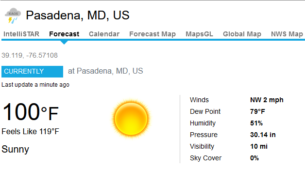
Hit 100F at my home station...first time recording that since it was set up in 2018. Now 80/74.
-
11PM EWR: 93 NYC: 91 LGA: 90 JFK: 84 New Brnswck: 83
-
I topped out at exactly 97.9 today held down by the cloud cover. Got to 98.6. My PWS registered a DP of 84.9 ° at 3:00 PM today, with a HI of 127.6. That seems suspect but perhaps not completely out of the realm of possibility given that our soil is still quite moist from the 8+ inches of rain we got last week. Edit: Looking at the NWS site, it appears RWI was "only" measuring a DP of 73 ° at 2:53 PM so my 84.9 readings seems unrealistic. Still, it's dang humid.
-
BOS 91 at 11PM. I’m pretty sure I’ve never seen that level of heat around here. I’m at 84 and walking but it’s still damned hot. If I didn’t have ac I’d be heading to a hotel tonight.
- Today
-
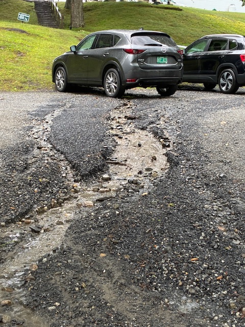
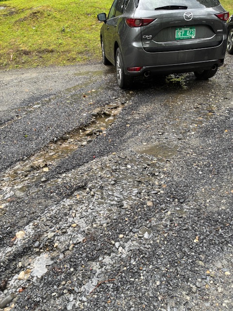
Storms blew through here 6:00-6:30. We were called off the golf course before any weather hit. By the time we got back to the clubhouse it started coming down really hard and winds were probably gusting 30+. The parking lot sustained a a little bit of damage. That’s my grey Mazda with the washout close to the tires.
-
And SLK only hits 89°.
-
shocking
-
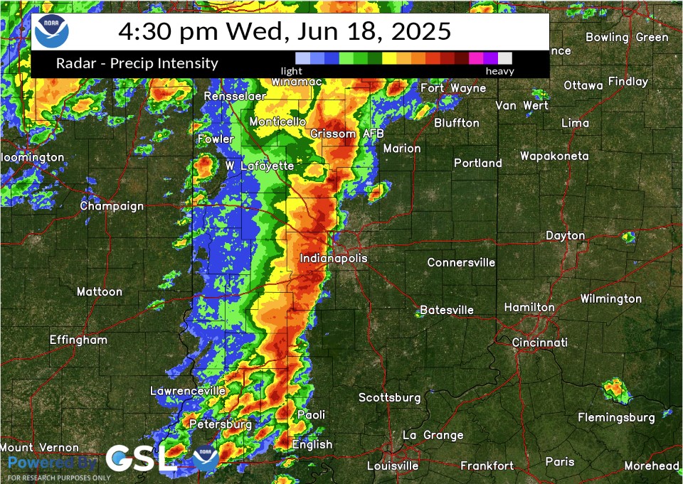
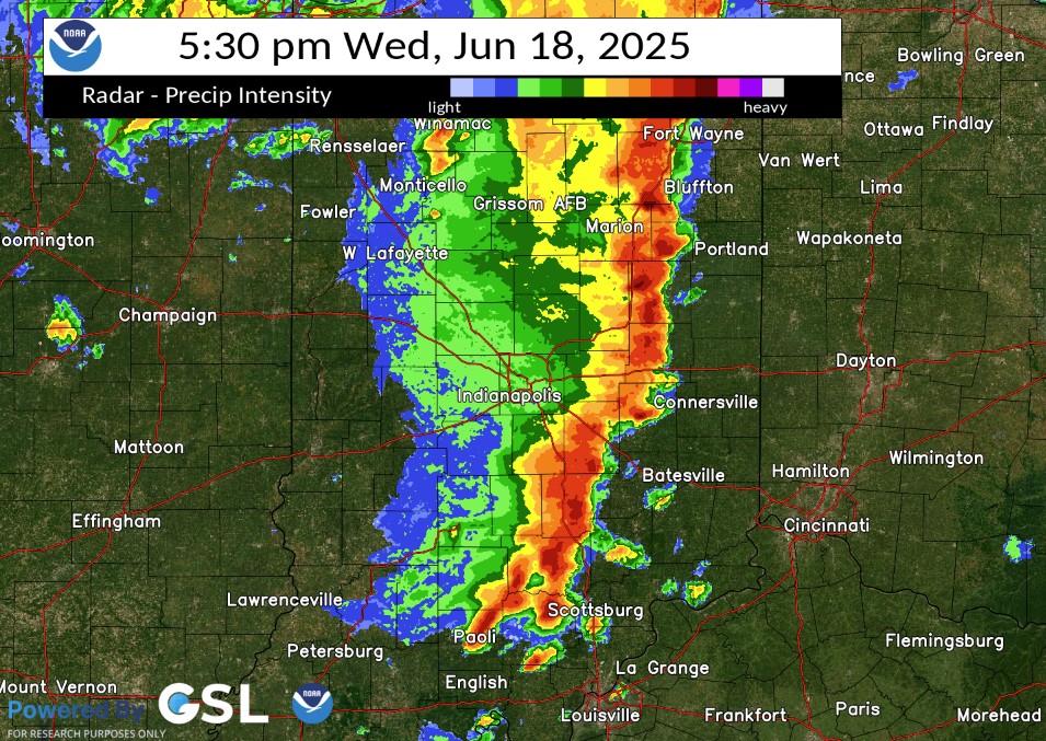
Well the tree and power line trucks are gone. I swear you'd have thought we got hit by a hurricane by as many of them that were all over this area until yesterday. Took a drive over the weekend and it was pretty bad for the trees, big trees, I mean 2-3 footers, 6in-1ft limbs down everywhere. From my previous hurricane life conditions were similar to a slow approaching hurricane as the specific area around me was hammered with up to a half foot of rain so we were already flooding when that line hit. That meant the trees and the ground were pre-soaked and primed to fall if there were strong enough winds and there were. Easily close to 1 min sustained strong TS force with Cat 1, maybe Cat 2 gusts through that area. Eerily similar to how widespread tree damage is caused along the coast in strong TS's/weak Hurricanes only without a storm surge. Been awhile since I've seen that much widespread tree damage around here, especially central Madison over into Delaware and Blackford counties. Along with the gusting "almost a D word" line there was also a significant downburst, IMO, through that area as a pre-frontal cell that blew up ahead of that line was consumed within it. You can see it in these 2 radar images from KIND's event page. The first Image, its in front of the main line as it was blowing up just SW of Marion and the second, you can almost see the exact shape of it embedded within the line just ENE of its previous position almost directly S of Marion. What was even more interesting, to me anyway, was a very small ragged "donut hole" type feature immediately behind it. That "donut hole" artifact or whatever it was passed right over my position where I nearly hit a tree as it came down. I don't think its radar shadowing or anything like you would see during a hurricane. I really think, IMO, its a radar image of a downburst or microburst (are there Sting Jets in severe lines?lol) from or enhanced by that rapidly forming small SUP out ahead, possibly from it collapsing within the line accelerating the forward "gust front" even more. I mean that thing shot up to 55kft in like 20min on Radarscope before the "Meg" line ate it lol. That's why I was chasing it. It had a rapidly lowering wall cloud, a good hail core (2-2.5 inchers reported directly under its position in the Alexandria, Summitville areas) and was just forming a nice tail/hook on radar (you can see that a bit in the first image). Back flow was ramping up into that little SUPs gut as the updraft accelerated. Went from maybe 15 to 20KTs, more parallel flow from the SSW, then suddenly veered to easily 30-35KTs from the SSE as I got about 2 miles S of it. I'm more than likely over analyzing it lol. It more likely the ton of very localized rain that resulted in so many large trees and limbs concentrated in that area as opposed to more spread out in other areas. I counted at least 65 entire trees larger than 2 feet either uprooted or snapped just on my 2 hour drive. North and south, where they didn't get massively presoaked there was not nearly as much concentrated tree damage though. But those radar images kind of puzzled me when KIND put them out Sunday triggering the ADHD non scientist in me One of the stranger storm chases I've done. Wasn't prepared, very chaotic spur of the moment chase looking out the windows, at the radar on the phone at 45 to 50mph on country roads (around Moonville IN, the worst place to chase lol), in and out of densely wooded areas along White River and suddenly dodging falling trees and sideways rain all at the same time lol. Whatever, sorry for the long post, I'm just out of heat therapy but it was nutz lol. (Don't get on me about safety, y'all have done it before lmao) https://www.weather.gov/ind/june182025severe
-
Currently 81. Feels Like...
-
Highs: EWR: 103 JFK: 102 ACY: 102 TEB: 101 ISP: 101 LGA: 101 PHL: 101 BLM: 100 *(no intra hours readings) New Brnswck: 100 NYC: 99 TTN: 98
-
It was hot...
-
 Cooling off very slowly here on si, finally dropped into the 80's at 88°.
 -
 Bdr yes Isp yes Nyc no Jfk close Lga tie Ewr tie Hpn yes
 -

2025-2026 ENSO
Stormchaserchuck1 replied to 40/70 Benchmark's topic in Weather Forecasting and Discussion
The further into the Summer you go, the stronger the Jan-Feb PNA correlation is to PDO -
Yep. It's late June and we are still waiting for the first MCS activity of the year. Severe season has been a dud.