All Activity
- Past hour
-
Rainfall 3 days totals NYC: 1.74 JFK: 1.73 LGA: 1.70 EWR: 1.15 New Brnswck: 0.97 TTN: 0.25
-
Lows:EWR: 32 (1932)NYC: 37 (1988)LGA: 40 (1993)JFK: 37 (1993) 1993 was really interesting we went from endless historic heat to record cold in October back to historic heat in mid November followed by a historic winter.
-
If the banding set up over them it would have upped the seasonal total at the park to about 18", a bit below their long term seasonal average of about 25". Certainly not "well below".
-
why would it be a computer coding pain as opposed to just staying on one time all year long? some states don't even go to DST.
-
 JFK had even higher winds didn't they? I saw some reports of 60 mph winds on Long Island
 -
Because you claimed the "cooling period" started in January and February, so I wanted to roll forward that "cooling period" to the months afterwards, but I couldn't find it. To answer your question from January (where you chose to only include a map from January through February 21st) No, it is not.
-
1.40" in Haverhill. While the total is beneficial...averaging under 0.04"/hr for the duration of the storm is pretty boring.
-
"President Trump is urging Congress to pass legislation that would make daylight saving time permanent," Earlier this morning it was reported that there is new pressure from the Whitehouse to stay on Daylight savings time. With only a little more than 3 weeks left it seems unlikely and also a computer coding pain. Again, the likely outcome will be to stay as we are now and clocks will go back to Standard time this fall and ahead in March. It will be interesting if something does materialize to test (POC) this fall by remaining on Daylight Savings time. Not sure an executive order would work. I believe in the 70s (1973) it was house/senate voting on it and the same in Oct 1974 to revert back to the changes as well as 2007 extending DST from April - Oct to March - Nov (early) and ST from Oct - Apr to Nov - Mar.
-
 Nor’easters have been few and far between in recent years. This was our first one in quite some time. It’s the only time all year that we had NE gusts over 45 mph at place like LGA. All the other days with winds gusts over 45 came from a more westerly component.
- 682 replies
-
- 1
-

-
- heavy rain
- damaging wind
- (and 2 more)
-
The duration also has to be factored in. I simply can't tolerate a three day rainstorm. When we really start controlling the weather I would like our first noreaster to happen in December and our last noreaster to happen in March, nothing before and nothing after, Chris. My back, shoulders and neck has been hurting for the past three nights and only started getting better this morning (my shoulders are still sore though.) I turned my space heater up to 83 degrees this morning which helped alleviate the pain and soreness. I can tolerate this in the winter (especially with snow which is far better than rain and does not cause this kind of pain.) Not in October.
-
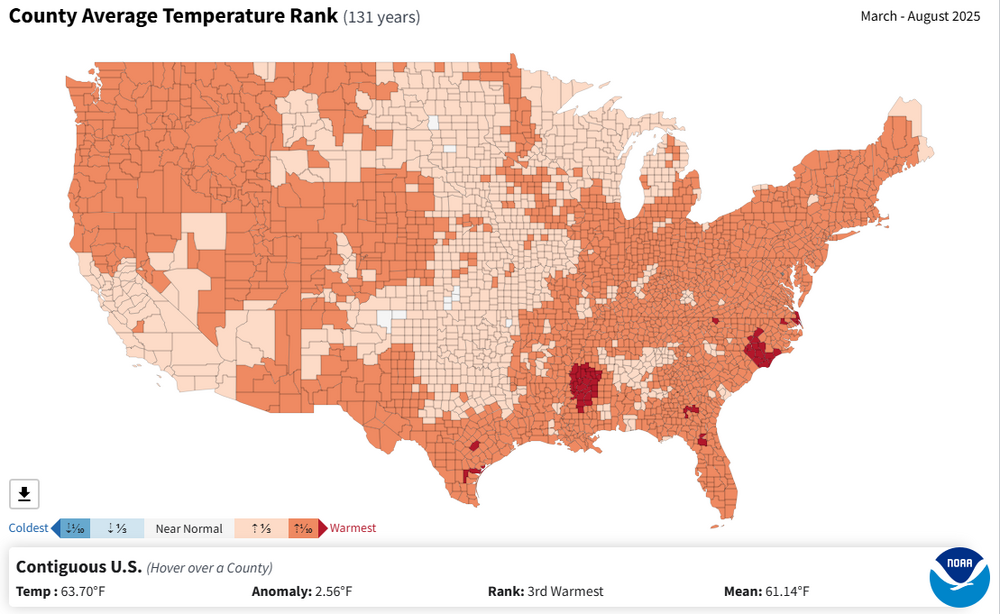
Records: Highs: EWR: 85 (1975) NYC: 84 (1920) LGA: 82 (1975) JFK: 82 (1990) Lows: EWR: 32 (1932) NYC: 37 (1988) LGA: 40 (1993) JFK: 37 (1993) Historical: 1909: An F3 tornado struck Pittsburg Landing and Stantonville, TN killing 23 people and injuring 80 others. 1933: An F3 tornado destroyed farms near Sayre, Oklahoma; three people died, one was hurt. One family was found two hundred yards from the foundation of their destroyed home. A seven-year-old girl was found alive in the arms of her dead 74 year old great-grandmother. (Ref. Weather Guide Calendar with Phenomenal Weather Events 2012 Accord Pub. 2011, USA) 1941: America's first television weather forecast was broadcast on New York's WNBT (later WNBC). There weren’t many televisions at that time, so viewers were limited to perhaps a few hundred people. The weathercast consisted of a sponsor's message followed by a text screen containing the next day's forecast. 1957 - Floodwaters roared through a migrant labor camp near the town of Picacho AZ flooding fifty cabins and a dozen nearby homes. 250 migrant workers lost their shelters. The month was one of the wettest Octobers in Arizona weather history. (The Weather Channel) 1965 - Heavy rains hit the coastal areas of southeastern Florida. In a 24 hour period rains of twenty inches were reported from Deerfield Beach to Fort Lauderdale, with 25.28 inches on the Fort Lauderdale Bahia-Mar Yacht Basin. Flooding that resulted caused considerable damage to roads and streets. The rains inundated numerous newly planted vegetable fields, and some residences. Ten miles away just 4.51 inches of rain was reported. (14th- 15th) (David Ludlum) (The Weather Channel) 1966: Late season severe thunderstorms brought softball size hail to parts of Brown, Dodge, Freeborn, Pipestone, Ramsey, Rock, and Steele Counties in MN. An enormous hailstone crashed through the windshield of a truck near Claremont in Dodge County, MN. It was reported to be 16 inches in circumference. (Ref. Weather Guide Calendar with Phenomenal Weather Events 2011 Accord Pub. 2010, USA) (Ref. AccWeather Weather History) Iowa struck by devastating late season tornado outbreak. A total of 12 tornadoes touched down, including an F4 that devastated a large part of Belmond Iowa. It was the day of the homecoming parade in the town, but fortunately the threatening skies had caused the crowds to break up before the twister's arrival. 6 people died in this tornado. 75 of the 112 businesses in the town were destroyed. Damage totaled $12 million. (Ref. AccWeather Weather History) 1969: Portland, OR recorded its earliest freeze ever as of 1969. (Ref. AccWeather Weather History) 1981 - Four days of heavy rain across northern Texas and southern Oklahoma came to an end. The heaviest rains fell in a band from southwest of Abilene TX to McAlester OK, with up to 26 inches reported north of Gainesville, in north central Texas. The heavy rains were the result of decaying Hurricane Norma, which also spawned thirteen tornadoes across the region. Seven deaths were attributed to the flooding. (Storm Data) 1984 - Dense fog contributed to a 118 vehicle accident on I-94, just south of Milwaukee WI. It was the seventh day of an eight day stretch of dense fog. At the time of the accident the visibility was reportedly close to zero. (Storm Data) 1987 - Sixteen cities, mostly in the Appalachain Region, reported record low temperatures for the date. Record lows included 43 degrees at Lake Charles LA, 35 degrees at Augusta GA, and 27 degrees at Asheville NC. Gale force winds buffeted the Carolina coast. Light snow fell across parts of Wyoming, Colorado, and western South Dakota. (The National Weather Summary) 1988 - Forty cities in the eastern U.S. reported record low temperatures for the date. Elkins WV was the cold spot in the nation with a record low of 18 degrees above zero. Thunderstorms in Arizona drenched Phoenix with nine inches of rain in nine hours, the fifth highest total for any given day in ninety-two years of records. Carefree AZ was soaked with two inches of rain. (The National Weather Summary) 1989 - Thunderstorms produced severe weather over Michigan during the morning, and over New York State and Connecticut during the afternoon and evening hours. Thunderstorms spawned two tornadoes, and there were ninety reports of large hail or damaging winds, including seventy reports of damaging winds in New York State. A tornado at McDonough NY killed one person and injured three other people. Strong thunderstorm winds gusted to 105 mph at Somerset. Temperatures warmed into the 80s and lower 90s over much of the nation east of the Rockies, with eleven cities reporting record high temperatures for the date. Afternoon highs of 81 degrees at Beckley WV and Bluefield WV equalled October records. (Storm Data) (The National Weather Summary)
-
 I was hovering around .15 then last evening a random tiny yellow cell went through so I had a brief downpour.
 -

Spooky Season (October Disco Thread)
Typhoon Tip replied to Prismshine Productions's topic in New England
Kerry Emanuel, el al, MIT describe the Polar Low phenomenon in a paper titled, "Polar Lows as Arctic Hurricanes" The abstract alone is geek's one-eyed monster worth stuff ... "Satellite observations of the polar oceans have revealed the presence of small, intense vortices that often resemble hurricanes, having clear central eyes surrounded by deep convective clouds. Recent aircraft and drop sonde data also show that these storms, like hurricanes, occur within deep moist adiabatic atmospheres and possess warm cores...." ( oh baby; don't forget the step children) I recall back in 2002, the GGEM of that era had a propensity for fusing, or threatening to do so, CAG originating TC ejecta up along the barolcinic wall east of strong +PNAP trough amplifications ( ... that's code for Mr Margrave's chart up there in this thread...). Anyway, Sandy alllllmost succeeded, but I wonder if Sandy teaches us, before ever observing the Sci Fi hyper bomb to best all fantasies, just how hard it is to actually get that to happen. Purely statistical occurrence, Sandy was something like a 1::500 year eturn rate ... does that grossly mean a purer performing phase is 1:1000? ...10,000? But that excerpt from Kerry's paper above, does lend some intrigue. If the thermodynamics in the tropical cyclone are some how comparable in the internal engine of the arctic variant, is it ever possible to go directly from a TC end of the spectrum right to the arctic end, in some kind of fantastic transition event? It may be one of those deals where it is mathematically possible, but practically so improbable due to everything that has to happen right in precise non-negative interfering order, that it is too unlikely to ever actually be observed. Still ... man. How would that look... and would it be mathematically possible to constrain George from blowing a gasket if that was like in the model movies (now that would be bombogenesis). Either way, that above is not really that. It's not cold enough... What that would do is just transition, albeit rapidly, from a TC into either an ETC. Or, it gets sheared and pulled apart like a star wondering too close to black hole ...getting absorbed into an ongoing ETC genesis. -
55 / 53 with 1.09 in the bucket and just about 72 hours of clouds and counting. Clouds limger till later. Clear out Wed with a brief warmup to upper 60s / low 70s before cooling later Wed - Fri morning. Dry next 4-5 days with a beautiful upcoming weekend - sunny and low - mid 70s in the warmest areas. A bit of a back and forth - with warmth outweighing the cool overall beyond next Monday front. 10/14: Coastal departs Cloudy / showers 10/15 - 10/17 : Dry / cooler 10/18 - 10/19: Great weekend - warmer (low - mid 70s) 10/20 : front next shot at rain - looks light 10/21 - Beyond : Overall (back and forth) bu warmer overall
-
I haven't seen any 3 day storm totals. Has anyone officially posted them?
-

Spooky Season (October Disco Thread)
kdxken replied to Prismshine Productions's topic in New England
Wishing you well as long as we don't get any more. -
 You got drenched. 0.08" here in the Three Bridges area. Thats my Sunday plus Monday total.
 -

The return of the elusive Nor'easter. Drought buster or bust?
wxdude64 replied to dailylurker's topic in Mid Atlantic
Can beat that, a 'T', not even enough to wet objects down here for the 'event' total. -
We had breezy conditions all day yesterday…nasty day to say the least…but nothing damaging. We had a lot of rain..around 3 total”. Rained nonstop all day yesterday. Definitely was in the goods. When the snow version comes….I’ll be in the dry slot for sure.
-

Central PA Fall Discussions and Obs
mahantango#1 replied to ChescoWx's topic in Upstate New York/Pennsylvania
But if temps were border line through the storm and also the sun was out to at time during this nor'easter. Just how much snow would have been left to measure over the course of 3 days? We can only hope for a better outcome for this upcoming winter. -
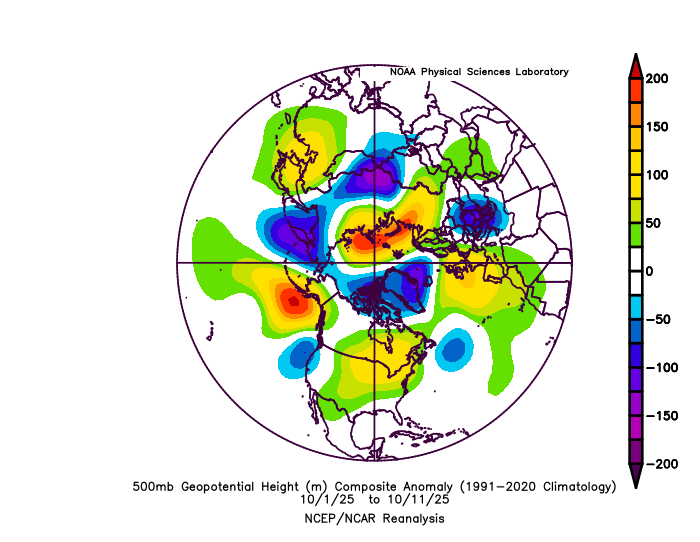
It’s possible the record low Arctic sea ice in the Kara and Barents is helping to strengthen the blocking there leading to most of our blocking episodes being more -AO dominant than -NAO dominant. Zack Labe @zacklabe.com · 1d In contrast to the other side of the #Arctic, sea ice along the Atlantic front is a record low for this time of year. This relates to the recent record warmth and southerly winds/waves pushing the marginal ice zone closer to the North Pole. Data from @nsidc.bsky.social (nsidc.org/data/seaice_...). ALT 39
-
Local station, KEEN, reports .34 inches total. I am about 20 miles away, and that seems right for here, too. We were under a giant hole in the precip most of yesterday. I am happy to see the big totals from parts of New England!
-

E PA/NJ/DE Autumn 2025 Obs/Discussion
BBasile replied to PhiEaglesfan712's topic in Philadelphia Region
Total is at 0.49". Still have an almost imperceivable mist falling. 53F -

The return of the elusive Nor'easter. Drought buster or bust?
nj2va replied to dailylurker's topic in Mid Atlantic
The constant drizzle storm -

Central PA Fall Discussions and Obs
pasnownut replied to ChescoWx's topic in Upstate New York/Pennsylvania
i also find it amusing that it was supposed to be another active year for hurricanes, and the "best" event that we got....was yesterdays "noreaster".