All Activity
- Past hour
-
Welcome to the party GFS.
-
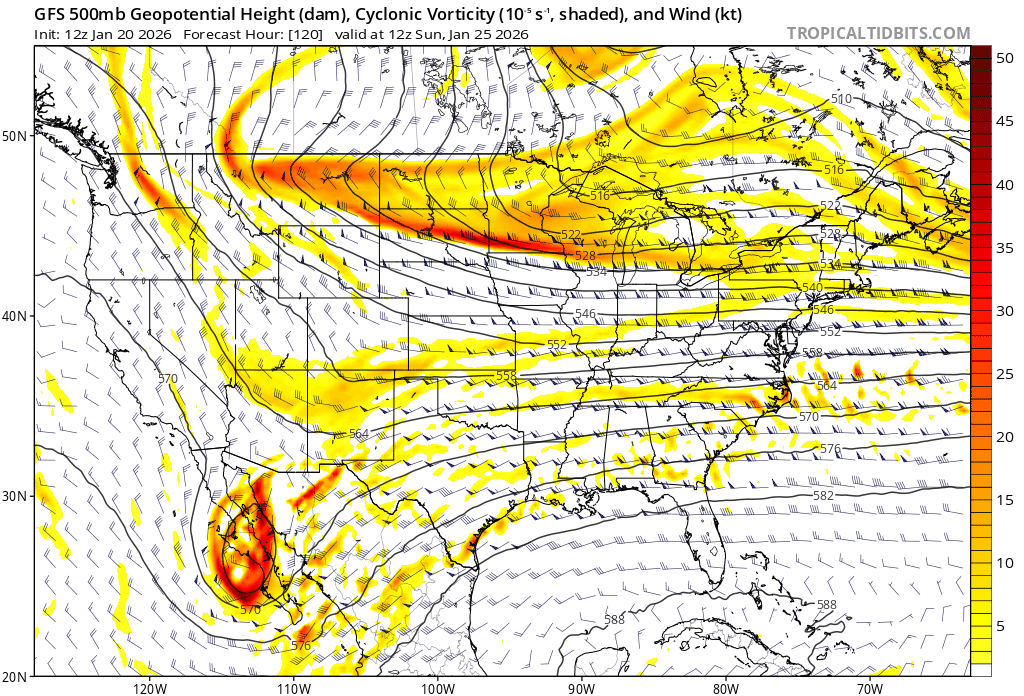
These streams are so close but just refusing to interact so far. It's not squishing our storm too badly though so I don't hate it.
-
The GFS may go for 3 feet.
-
18z GFS, along with some other modeling is showing a bit quicker onset (by a few hours) vs. modeling the last 24 hours. I think modeling slowed the onset for a few runs and is now sensing overrunning and a quicker onset, typical of setups like this.
-
Wait a minute..might be adding more on, lol Still going at 132
-
GFS much quicker with the storm as well.
-
It’s a really nice course correction from 12z taking the mass fail scenario back to close to off table. Seeing its AI be way better at 18z also helps a whole lot.
-

Possible Record Breaking Cold + Snow Sunday 1/25 - Tuesday 1/27
NJwx85 replied to TriPol's topic in New York City Metro
Going to be a big hit. Surface is way North. -
I’m not getting on board until it survives past the 96-84 hour mark which BAMwx described as a graveyard where similar storms have died.
-

January 2026 regional war/obs/disco thread
codfishsnowman replied to Baroclinic Zone's topic in New England
I was ten years old and I lived in central Connecticut. I remember getting out of school to a lead grey overcast....no dim sun. Before I went to bed Hilton was on the news up in the helicopter saying there would be two to four inches of snow as we would be getting a glancing blow. My mom had called earlier from Port Chester NY telling of more than six inches of snow already and it just looked like thick fog outside. I woke up early at six am and it was winding down but we were buried. Both my Dad and Grandpa said a good two feet. The day turned out beautiful with bright sunshine and milder temps up to around 32 in the afternoon. The piles were insane. I wish I had been a little older because I would've stayed up and watched it all night. . -
It's beyond folks-worthy across Central and Southern VA so far. Historic really. Widespread powder up to southern PA.
-
It's definitely good. It's just hard telling QPF with these shitty maps. I don't call it unless I'm 100% sure.
-
Yeah I agree. Frosty Oceanic Lateral Konvection Scenarios are tricky but great to track. I remember my first one in ‘68.
-
 Yeah. A reasonable estimate is better than accepting obviously bad data. Just take an avg of cocorahs ratios in the area and apply it to the accepted snow total for the site. It isn’t difficult.
 -
Possible Record Breaking Cold + Snow Sunday 1/25 - Tuesday 1/27
NJwx85 replied to TriPol's topic in New York City Metro
Much better
-

January 25/26 Jimbo Back Surgery Storm
NorthHillsWx replied to Jimbo!'s topic in Southeastern States
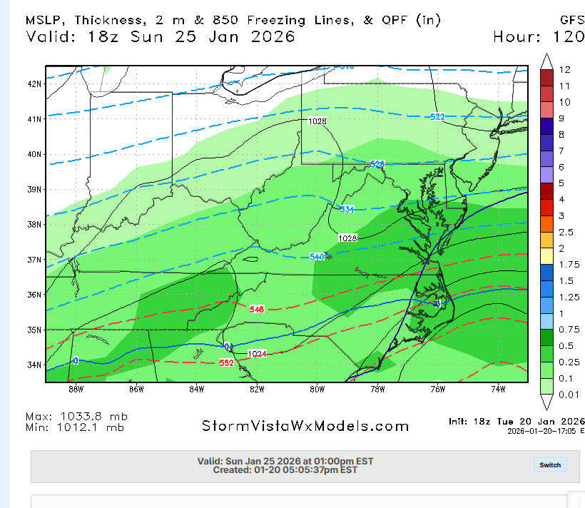
If we stay all frozen we will pass the assignment (6”). There’s so much QPF it might be 4” snow 4” of sleet. That’s a major passing grade with temps around 20 -
FWIW, the 18z AI GFS does take the far southern and southeastern areas of TN above freezing for a few hours at 700mb. Other than this small area, it looks like it's a snow smoke show.
-
Through 12z Sunday:
-

Possible Record Breaking Cold + Snow Sunday 1/25 - Tuesday 1/27
EasternLI replied to TriPol's topic in New York City Metro
Seems like its been slowly trending towards doing more of that too. Here's the last 7 runs. -

Possible Record Breaking Cold + Snow Sunday 1/25 - Tuesday 1/27
Tatamy replied to TriPol's topic in New York City Metro
Agree. The pictured event took place with temperatures between 28 and 30. It caused widespread power outages -
-
This will be a monster run, but I do not trust the GFS on picking up WAA in the valley whatsoever.
-

Appreciating Each Other/Poster Compliments
Roger Smith replied to SnowenOutThere's topic in Mid Atlantic
Not to mention I have the longest daily commute to subforum offices. I appreciate @everybody. -
I actually would lean towards reality ending up a pretty clean phase if we can get those pieces where this frame has them. Nice correction back in the right direction for the gfs.
-
Relative to 12Z, it's FOLKS worthy! But hell, that's a very low bar! (Would a "Guys" be possible though?)