All Activity
- Past hour
-

July 2025 Obs/Disco ... possible historic month for heat
weatherwiz replied to Typhoon Tip's topic in New England
Those storms exploded along the outflow -
 Light rain and thunder
 -
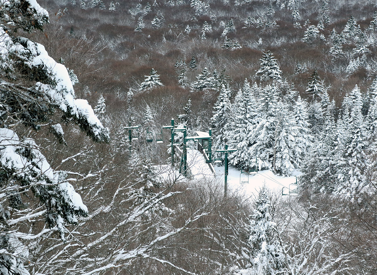
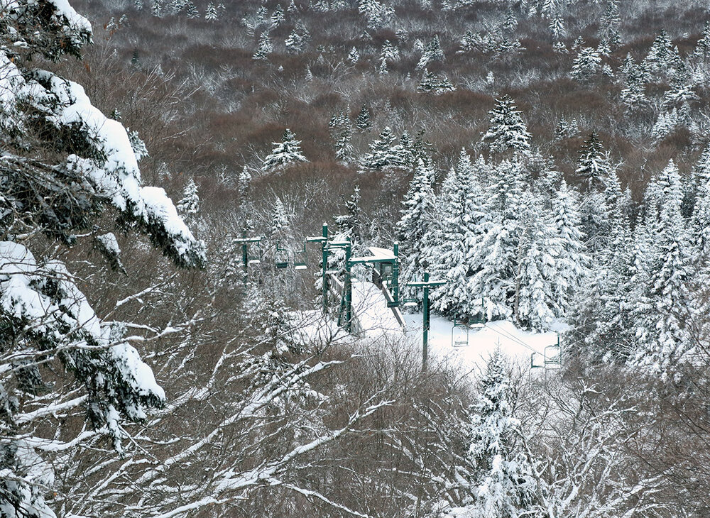
The winter/ski seasons all blur together for me, which I think is in part due to our climate here in the Northern Greens. While we certainly get memorable storms, the majority of the winter features day after day with light to moderate snowfall events, which don’t stand out as easily from one season to the next. In any case, it’s a good climate to maintain high-quality snow surfaces for skiing and riding, and it’s one of the reasons that I really like having the reports from my ski outings to refresh my memory for specific periods though. I was curious about that strong start you mentioned for the 2023-2024 season, and indeed it does pop up on the plot for the Mt. Mansfield Stake data – the snowpack depth hitting 40 inches in the first half of December is a great place to be, and it quickly gets a lot of off-piste terrain in play. I checked my snowfall numbers and saw that our site in the valley only picked up about a foot of snow in the first half of December, which is below average and certainly not a standout performance. After looking a little closer, I realized that November 2023 also brought us 20 inches of snow in the valley, and that was a big help in priming that great start to December. I hadn’t caught that the first big rise in the 2023-2024 snowpack plot is actually from the end of November, but I see in my data that we had 6 snowstorms in the valley in the last 10 days of the month. On my Bolton outing on the 28th I measured the snowpack depth at 20” at 3,000’ and then on the 29th it was up to 24”. The skiing was great even before the calendar hit December.
-

July 2025 Obs/Disco ... possible historic month for heat
Baroclinic Zone replied to Typhoon Tip's topic in New England
Looks like a rough I-84 drive right now.
-

July 2025 Obs/Disco ... possible historic month for heat
Damage In Tolland replied to Typhoon Tip's topic in New England
80.9/ 76 Can we even gin up a storm ? -

Summer 2025 Medium/Long Range Discussion
cyclone77 replied to Chicago Storm's topic in Lakes/Ohio Valley
The numerous days above 90 with full sun definitely have sped things along. -
July 2025 Obs/Disco ... possible historic month for heat
Damage In Tolland replied to Typhoon Tip's topic in New England
Not every year. -
 Barely light rain here yet we had a close strike of lightning with thunder
 -

July 2025 Obs/Disco ... possible historic month for heat
DavisStraight replied to Typhoon Tip's topic in New England
85/74 but a nice little breeze that feels good. -
 Luckyyyyy - in Napoleon Dynamite voice
 -

E PA/NJ/DE Summer 2025 Obs/Discussion
RedSky replied to Hurricane Agnes's topic in Philadelphia Region
That can't miss Famous last words -

July 2025 Obs/Disco ... possible historic month for heat
RUNNAWAYICEBERG replied to Typhoon Tip's topic in New England
Late Aug thru Sept is ideal summer. -
 Big bust here
 -
July 2025 Obs/Disco ... possible historic month for heat
Baroclinic Zone replied to Typhoon Tip's topic in New England
Not my station. It’s about 1/4mi up street. https://www.wunderground.com/dashboard/pws/KMAATTLE150/graph/2025-07-1/2025-07-1/daily I haven’t been able to find/see where the station is set up. -

E PA/NJ/DE Summer 2025 Obs/Discussion
BBasile replied to Hurricane Agnes's topic in Philadelphia Region
Looks like I'm finally going to get some heavy rain. Won't last too long, but the storm structure looks good from the drone's view.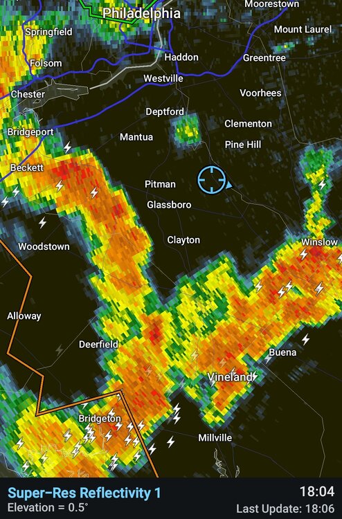
-
July 2025 Obs/Disco ... possible historic month for heat
Damage In Tolland replied to Typhoon Tip's topic in New England
That’s not typical . Usually get ebbs and flows but some yrs(probably this one) September and Oct can be more dewy than not -

July 2025 Obs/Disco ... possible historic month for heat
CoastalWx replied to Typhoon Tip's topic in New England
Outflow sparking up cells near Kev. let’s see how the webbed hands deflect here. -
We lost power for about 20 minutes. 1.50 and raining currently
-
July 2025 Obs/Disco ... possible historic month for heat
RUNNAWAYICEBERG replied to Typhoon Tip's topic in New England
Nobody said cool temps. Don't be a tool. -
July 2025 Obs/Disco ... possible historic month for heat
CoastalWx replied to Typhoon Tip's topic in New England
You seem to run high? -
July 2025 Obs/Disco ... possible historic month for heat
weatherwiz replied to Typhoon Tip's topic in New England
Surprised at the 1” hail tag. Tough to get 1” hail in this setup. Poor lapse rates and very warm aloft. Would need a monster updraft to achieve that. -

July 2025 Obs/Disco ... possible historic month for heat
Torch Tiger replied to Typhoon Tip's topic in New England
faded like you after a 50mg gummy ...dews will drop in September. at least 8-10 weeks before the weather turns to shit with regular lower dews and cool temps -

July 2025 Obs/Disco ... possible historic month for heat
radarman replied to Typhoon Tip's topic in New England
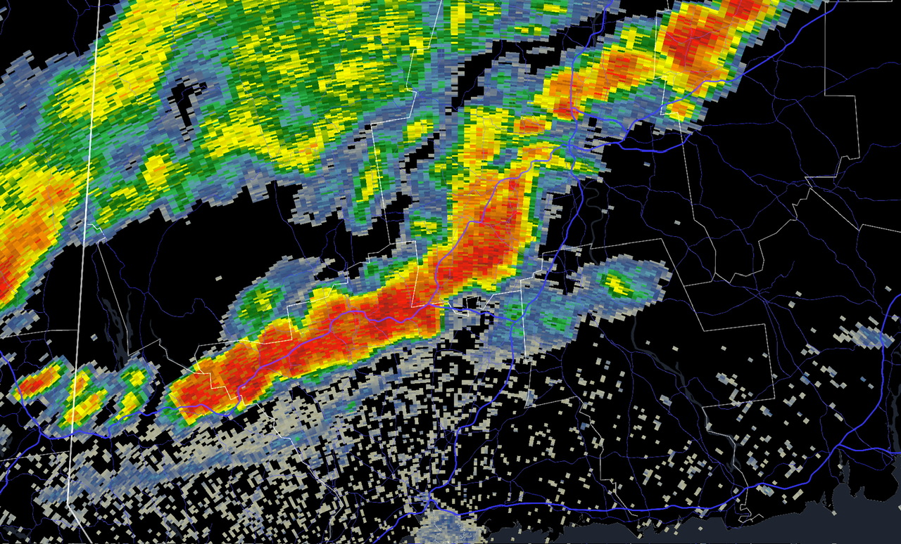
God I love this location for severe * At 547 PM EDT, a severe thunderstorm was located over Belchertown, or 8 miles southeast of Amherst But seriously though I doubt this one verifies. Classic SPS event IMO -
Yeah as bluewave says we can look at what the mjo does in Oct to see if we get that kind of mismatch. I also think we’ll have better blocking because the qbo is negative this time, which is the main difference from last winter and from 22-23. Maybe that means we get an extra episode thrown in, and/or extend each blocking episode by a few days or so.
-
July 2025 Obs/Disco ... possible historic month for heat
RUNNAWAYICEBERG replied to Typhoon Tip's topic in New England
More like 6 weeks. End of Aug the dews typically fade some and a more enjoyable climo starts to take hold.