All Activity
- Past hour
-

2025-2026 ENSO
40/70 Benchmark replied to 40/70 Benchmark's topic in Weather Forecasting and Discussion
That is not as strongly positive as I had suspected. I'm doing a lot of seasonal work on the polar domain right now...will be interesting to see if we jive again. -
Surprise drink this morning, picked up about .10”
-

2025 Atlantic Hurricane Season
Kevin Reilly replied to BarryStantonGBP's topic in Tropical Headquarters
Hour 384 in regard to tropical development minus well be hour 1000+. This scenario will change at least 10x before we even get to hour 200 let alone 384. Interesting to look at but whether it is the 18z gfs or even this 0z Euro run for it to play out this way is unlikely. The only thing that these model runs tell me is that there will be an uptick in activity and wait and see what happens over the next 3-5 days. What I have noticed is that the models are pushing everything back 5-10 days which is also a typical caveat of modeling. What happened last year we were searching for 10 days out and hour 384 etc. and then we had storms like Hurricane Heleen blow up out of nowhere which could be the case this year. I would not watch 384 hours out but rather just make sure we are not missing something closer in time. I think the next 3-4 days of model watching and looking at other things like the visible and water vapor maps will be useful tools to locate harmless little low level or mid-level swirls that become something bigger in time. Mean time here in Kitty Hawk where I still am the strong gusty NE winds have begun again, and the beaches are once again closed to swimmers due to heavy surf and dangerous rip currents under 82-85 water temps. -
Someone (Wiz?) mentioned to look out for some scattered stuff.
-
I'll just point out that I don't think that is what he thought when his job was eliminated at the museum in Connecticut.
-
What has been causing all that convection and heavy rain for Hippy and NW MA? That wasn’t really modeled so widespread
-
So nice this morning. Next few days are going to be as good as it gets for early August.
-
As hoped, the atmosphere took my post as a challenge. Marginal risk today, slight just northwest of me Saturday. Not looking like anything huge, but better than it was looking just 24 hours ago.
-
Glad to know you feel that way. The probationary employees that were let go were not the fat in the organization. I know them, I had friends lose their jobs. I frankly find it offensive. That ho hum attitude about it all is definitely what is causing people to continue quitting government service in NOAA/NWS.
-
Have had less than 1/2" since July 16th. And no rain in sight.
-
My oh my, are we looking hot next week.
-
Cue the creepy DIT comment.
-
 jfc, im so sick of this summer already.
 -
Gosh, maybe one of those will visit! We are do.....
-
Some nice looking members on the EPS
.thumb.png.41dc4150ad73b08e68f6bb2927baf5f3.png)
-
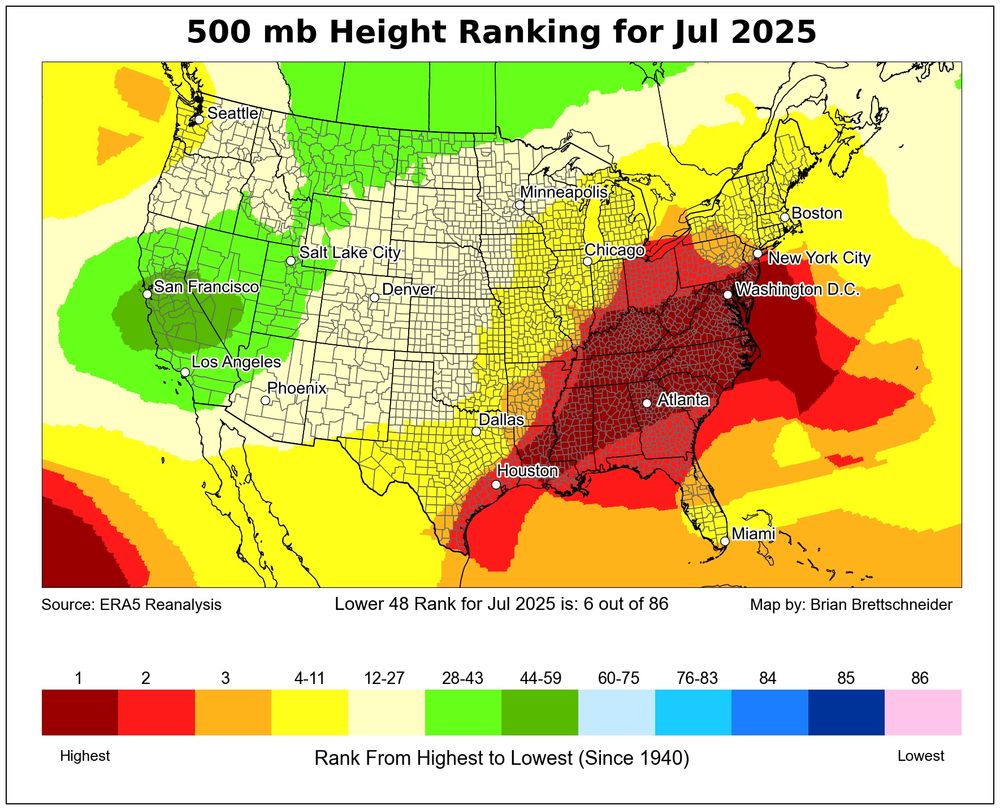
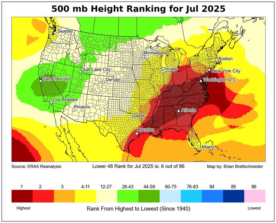
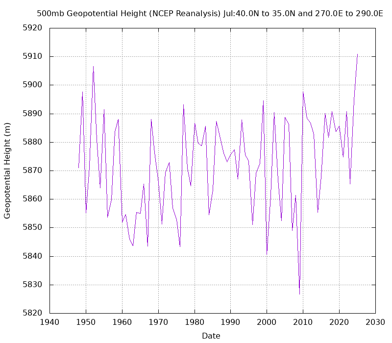
July was the strongest Southeast ridge on record for the month from NYC to ATL. This beats the previous record July 500mb heights set back in 1952. But the difference this time is that we had a +0.74 PNA for July. While July 1952 had a -1.23 PNA. So we continue to see these disconnects between the higher latitudes and mid-latitudes. This disconnect is why the Euro still has a Southeast ridge into next winter while also having a -EPO and +PNA.
-
$25,000 fine for using a trail system in the woods. They aren’t messing around up there.
-
Has anyone played the Shattuck in the past 10 years? Used to play it all the time until It got beat to hell. Supposedly it has recovered. Going to give it a try on Sunday.
-
I've played three of these and concur. The 10 Worst Golf Courses In America | MyGolfSpy https://share.google/rdDt9PUVEvMEr6Owf
- Today
-
https://news.novascotia.ca/en/2025/08/05/travel-activities-woods-restricted-prevent-wildfires?fbclid=IwQ0xDSwMBY_xleHRuA2FlbQIxMQABHrwJuYXtz01GIFhzMDl6tRQmO9qPIkhim2efdptit4YSQShQ2uedQmTBUGoF_aem_Os-YHBNtStld8HXYamK1nQ
-
 Not according to the models, perhaps, but the system to our south was close enough to be a possible "player". Future radar was showing that a few showers would be able to penetrate the blocking high.
 -
Gonna be in mexico city for a couple weeks so hope I don't miss too much action. monsoon season down there with highs in mid 70s and daily afternoon pop up storms, which sounds perfecto
-
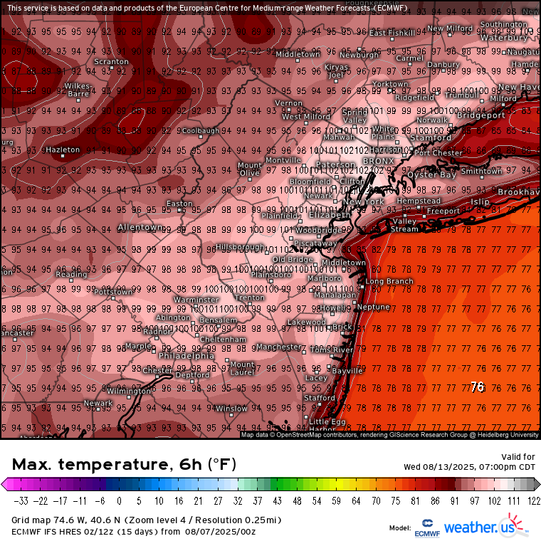
 Yeah, the Euro has all-time mid-August heat in the forecast. Just using Newark as a reference point, it gets places like Newark to 102°. That ties for the warmest ever recorded for this time of year. You can also see that Central to Northern Queens could reach 100°. Time Series Summary for NEWARK LIBERTY INTL AP, NJ Highest Temperatures August 11th through 20th Click column heading to sort ascending, click again to sort descending. 1 2005-08-20 102 0 - 1949-08-20 102 0 - 1944-08-20 102 0 2 2002-08-20 100 0
-
Such a drought in Nova Scotia they’re fining people if they go into the woods? Is this true? Where’s @Hazey
.thumb.png.4150b06c63a21f61052e47a612bf1818.png)


.png.9a7b007ad9170dc8180430760c260a50.png)