All Activity
- Past hour
-
US National Weather Service State College PA Favorites ·a day ago · Don't shoot the messenger...
-

October Comes Early: Late September Multi-Hazard Hybrid Storm
CoastalWx replied to WxWatcher007's topic in New England
It’s possible the storm might try to move west twice. Once late tonight and tomorrow, and then it moves kind of northeast and then starts moving north then Northwest south of Block Island. But that angle of approach will matter. The other question I have is the rain squalls. There definitely might be some squally rains with this models aren’t really all in agreement in terms of how much but it should be a good drink across most of southern New England. -
Low of 49
-
October Comes Early: Late September Multi-Hazard Hybrid Storm
CoastalWx replied to WxWatcher007's topic in New England
I think I did mention that a couple days ago in a post. But honestly to me that doesn’t matter in terms of sensible Weather. I’m just trying to figure out where the storm is going and what the winds and rain will be. It may briefly attain tropical characteristics, but once it gets towards 40 north, it’ll definitely become more subtropical. -
38.5 chilly degrees this morning with a thick fog. I didn't think it would plunge into the 30's overnight.
-

Septorcher 2026 Discussion - Endless Summer
dendrite replied to Damage In Tolland's topic in New England
Patchy frost on the grass here when I let the birds out. -

October Comes Early: Late September Multi-Hazard Hybrid Storm
jbenedet replied to WxWatcher007's topic in New England
I don’t think sub 990 mb mslp happens south of 40N in late September unless there is a tropical aspect to the system. Baroclinicity alone isn’t sufficient for that level of deepening. -

2026-2027 Fall/Winter Mountain Thread
Met1985 replied to BlueRidgeFolklore's topic in Southeastern States
52 degrees and drizzle here. -
I'm liking what I'm seeing so far this late summer/early fall. Getting these cold shots and coastal storms gives me a glimmer of hope for structure crushing snow on Tug Hill and potential for a HECS in this area.
-

October Comes Early: Late September Multi-Hazard Hybrid Storm
WinterWolf replied to WxWatcher007's topic in New England
Yes, I was being funny. But let me ask you this, Vortex95 has been talking about ST or even T for a couple days now…even when modeling wasn’t showing that at all. I didn’t see you mention any of that? Why is that? Was he seeing something you weren’t? -

Strong Nor'Easter/Hybrid Storm Late September 2026
TriPol replied to Rjay's topic in New York City Metro
There isn't a model that doesn't show a major east coast storm. GFS caved. -
Going to be a fun time on the beach free sand exfoliation
-

Strong Nor'Easter/Hybrid Storm Late September 2026
Tatamy replied to Rjay's topic in New York City Metro
It looks like they are not placing too much weight on the more consistent Euro. -
October Comes Early: Late September Multi-Hazard Hybrid Storm
WinterWolf replied to WxWatcher007's topic in New England
Well this is starting to look a little more significant overnight now..with possible ST or T transitioning. That can bring the wind here for sure. We’ll see how it goes today and tomorrow. -
 pharmacy mexico online order [url=https://solmedsdirect.com/#]mexico pharmacy list[/url] farmacia pharmacy mexico generic drugs
 -
 Tap tap.. tap tap tap
 -
-

Strong Nor'Easter/Hybrid Storm Late September 2026
qg_omega replied to Rjay's topic in New York City Metro
Upton not even thinking a wind advisory let alone warning -
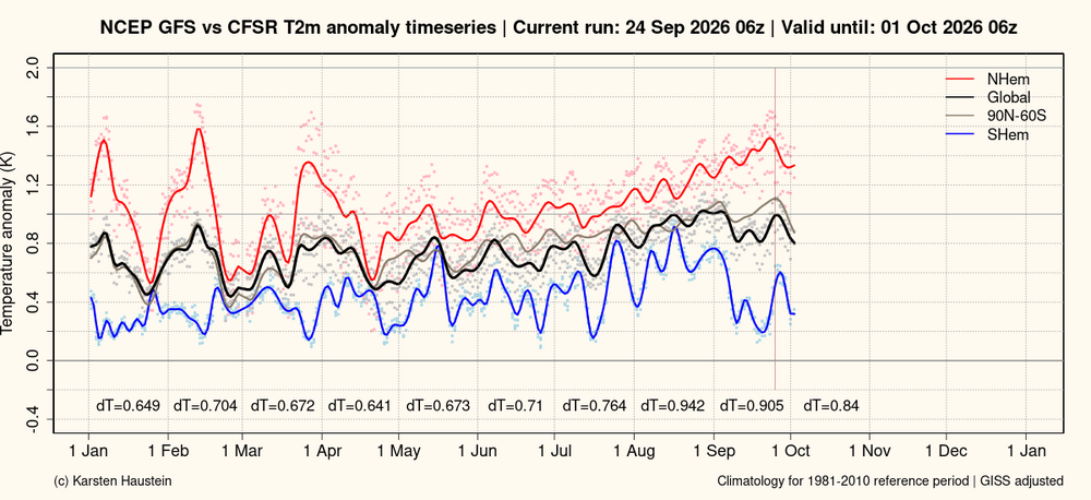
Globally September will end up cooler than August, due to a cool Southern Hemisphere paced by Antarctica. In strong contrast to September 2023 when a very warm Antarctica contributed significantly to "gobsmacking" warmth.
-
Low of 49
-
When I quickly first read this the 'roast' word was absent! I just did my own a few days ago with ginger seasoning this time.
-
Strong Nor'Easter/Hybrid Storm Late September 2026
TriPol replied to Rjay's topic in New York City Metro
This has got to change: .DISCUSSION... .KEY MESSAGE 1... Models in general agreement with a closed 500mb low over or near the forecast area Friday through Sunday. Given its location, anticipating the surface low to track near or not too far east of the 40N/70W benchmark during Saturday before meandering or retrograding toward the coast late in the weekend, then slowly departing during Monday as it weakens. Confidence in this track is still not high due to the closed/cutoff low aloft. Rain chances begin Friday morning, and mainly east of the city, rain is likely Friday afternoon through Saturday afternoon. For the the city and points west, rain chances are mostly below 50% up until Saturday afternoon and night. Still thinking that rainfall flooding impacts are little to none - just low chance for flooding across far eastern zones, and probably limited to minor nuisance and poor drainage flooding. Long Island, especially eastern Long Island, can handle a fair amount of rain, especially the long duration nature of the event. However, if the NAM verifies, a period of heavy rain is possible the first part of Saturday night, with over 2 inches of rainfall for the south fork of Long Island in a 6 hour period. If models trend west with the storm track, then western zones could have a chance of minor flooding. The Weather Prediction Center has placed southeast CT and central and easter Long Island in a marginal to slight risk of excessive rainfall from Friday through Monday night. As for winds, continue anticipating gusts to remain below advisory thresholds, but it could come close across eastern LI and SE CT late day Friday through Saturday morning. However, there may be isolated incidents of downed trees and power lines due to the heavy rain loosening the soil and weighing down leaves in combination with breezy/windy conditions. -
Heading down to Rehoboth this morning for a couple of days. Really looking forward to spending time outside experiencing some storm conditions. @CAPE let me know if you’re around for a beer. Dogfish releases their Oktoberfest on Friday, I think.
-
Septorcher 2026 Discussion - Endless Summer
dendrite replied to Damage In Tolland's topic in New England
Maybe at Furnace Creek. Tough way to run an endless summer. -
39 degrees this morning here in the Poconos.