All Activity
- Past hour
-
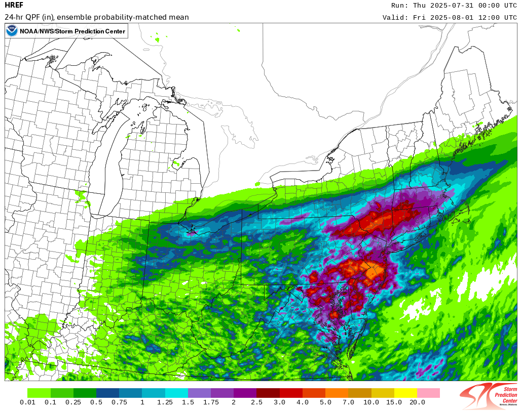
 From the 7/31 0z HREF:
-

July 2025 Discussion-OBS - seasonable summer variability
bluewave replied to wdrag's topic in New York City Metro
This July was a continuation of the rural spots in NJ not dropping below 50°. Prior to the big increase of our summer temperatures in 2010, they would regularly have the monthly low temperature in the 40s. Before 1960 it was typical to get into the 30s in July. So the July lowest temperature has risen by around +12 since 1893.
-
From CTP: Southern/Southeastern PA/Lower Susquehanna Valley Farther south, this area is more removed from the jet-streak dynamics to the north. However, this region is closer to the deepening surface low with strong surface-925mb southerly theta-e advection directed into the southeastward advancing surface front. A tropical air-mass (depicted by 2-2.25" PWATs and low-mid 70s dew points) will coincide within a warm sector that becomes increasingly unstable (MUCAPE between 1,000-2,000 J/kg). It is worth noting that SST anomalies along the Mid- Atlantic and Southeast coasts are well above normal too, acting as an abnormally rich moisture source for southerly low-level flow to draw from. By this afternoon, low-level WAA into the front will support storms enveloping the region with additional storms from the Laurel Highlands/south central Alleghenies tracking east. Modest vertical wind shear aloft will also support organized clusters of storms, some of which will have the potential to backbuild and train between the I-81 and I-95 corridors into tonight. Latest 12Z HREF guidance shows 24-hr probabilities for >3" of rainfall are high (>70%) across southeast PA. Just as concerning is this same region sports 30-60% chances for >5" of rainfall with 24hr PMM/LPMM values close to the ensemble maxima approaching 8 inches.
-

E PA/NJ/DE Summer 2025 Obs/Discussion
BBasile replied to Hurricane Agnes's topic in Philadelphia Region
One last flood watch for July. I currently have 3.21" of rain for the month. Will I finally be able to cash-in on one of these days? Maybe even reach average rainfall? Heat index is already 98F because of this "obnoxious" 79F dew point. -
We had a T during that storm. Pretty much all our rain was from the stratiform rain. Ive been measuring rain/snow imby for 30 years now. With my close proximity to DTW, many times, things like summer storms or winter snow squalls somewhat even out over the course of a season. Not literally dead even, but one time theyll get hit and i wont then the next time vice versa. In all those years, even in summer months, Ive never seen such a difference as this July.
-
so there ...
-
We have a Flash Flood Watch in effect from 2pm through 6am Friday morning. Rain and storm chances begin to increase as we move into this afternoon and into the night. One to as much as three inches could fall in spots. Following the rain we cool down and clear out by Friday night with a fantastic weather weekend on tap for the entire area. Days mainly in the 70's with nights in the 50's. Pleasant weather looks to continue for much of next week.

-
 Going to be places that get next to nothing from this esp west and south of the city while newrby locations pick up 3 to 5". Alot of people freaking out on fb about a potential July 14th repeat
-

E PA/NJ/DE Summer 2025 Obs/Discussion
ChescoWx replied to Hurricane Agnes's topic in Philadelphia Region
We have a Flash Flood Watch in effect from 2pm through 6am Friday morning. Rain and storm chances begin to increase as we move into this afternoon and into the night. One to as much as three inches could fall in spots. Following the rain we cool down and clear out by Friday night with a fantastic weather weekend on tap for the entire area. Days mainly in the 70's with nights in the 50's. Pleasant weather looks to continue for much of next week.
-
July 2025 Discussion-OBS - seasonable summer variability
donsutherland1 replied to wdrag's topic in New York City Metro
White Plains has reached 80° or above for the 30th day this month. That ties the July mark of 30 days, which was set in 2022. -

July 2025 Obs/Disco ... possible historic month for heat
kdxken replied to Typhoon Tip's topic in New England
Lolz zzz!!! -

July 2025 Obs/Disco ... possible historic month for heat
CoastalWx replied to Typhoon Tip's topic in New England
Thanks, didn’t see that. Working. so top 10ish. That’s pretty good. A couple cool rainy NE wind days preventing all out furnace. -
Yesterday's storm over the airport dropped 1.04 in 17 minutes. An absolute car wash of a storm.
-
Just got back in after watering and man is it hot already. At least no more mowing needed as the grass is completely dormant. Looking forward to spending hours out on the deck starting this weekend!
-
Good point. Thoughts last week of temps approaching the century mark down here have ended up in the 93-95 range in reality. It helped it feel so much more refreshing to be outside.
-

July 2025 Obs/Disco ... possible historic month for heat
ineedsnow replied to Typhoon Tip's topic in New England
-

July 2025 Obs/Disco ... possible historic month for heat
Brewbeer replied to Typhoon Tip's topic in New England
July will be remembered more for the humidity than anything else in my book. More days of AC required than any other July in recent memory. -
E PA/NJ/DE Summer 2025 Obs/Discussion
donsutherland1 replied to Hurricane Agnes's topic in Philadelphia Region
Philadelphia has reached 80° or above for the 31st day this month. That ties the July mark of 31 days. It is also the third consecutive year with 31 such days. The old record of two consecutive years was set during 2010-2011. -

July 2025 Discussion-OBS - seasonable summer variability
SACRUS replied to wdrag's topic in New York City Metro
9AM clouds pushing in slowly EWR: 80 NYC: 83 LGA: 81 JFK: 82 New Brnswck: 83 TEB: 83 -
July 2025 Obs/Disco ... possible historic month for heat
CoastalWx replied to Typhoon Tip's topic in New England
Logan won’t be due to so many sea breezes. Look at ORH, Blue Hill, and BDL. Maybe PVD too although I think they may be running cool still? Throw in CON and MHT too. I think many are close to top 5. It was a warm one. -

July 2025 Obs/Disco ... possible historic month for heat
Modfan2 replied to Typhoon Tip's topic in New England
Currently sunny down here at Yagoo Valley in RI -

July 2025 Obs/Disco ... possible historic month for heat
Typhoon Tip replied to Typhoon Tip's topic in New England
yeah i was pretty sure it was that late june one just curious. actually got to wondering how often it is to get 1k high orh to do that just in general - as in return rate. -
July 2025 Obs/Disco ... possible historic month for heat
ineedsnow replied to Typhoon Tip's topic in New England
I thought there was a bit more.. but even so my point is he didn't get his top 5 and this morning he was saying it was and how wrong I was. But I admit it was hotter than I thought.. He will never admit he was wrong. -

E PA/NJ/DE Summer 2025 Obs/Discussion
JTA66 replied to Hurricane Agnes's topic in Philadelphia Region
I know nothing about modeling, but it seems they struggle with convection. It's a day to pay more attention to Mt. Holly and the radar than short-range models. Already 82F at 9am. Will probably make another run at 90F if cloud cover holds off long enough.