All Activity
- Past hour
-

November 2025 general discussions and probable topic derailings ...
powderfreak replied to Typhoon Tip's topic in New England
November.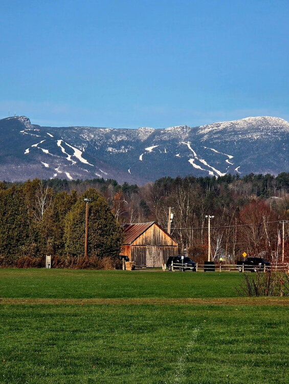
-
Yes. So, even if there’s no more ACE, 2025 will end above the 1991-2020 average of 122.
-
We are at 132.6 total ACE now?
-
 Groton taking the crown of coldest coastal spot in CT so far this fall.
 -
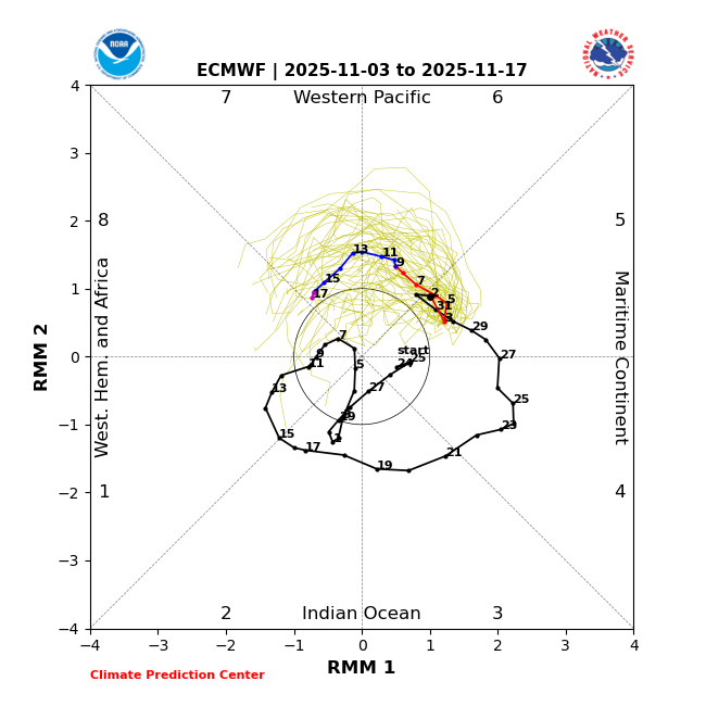
Eps had a bit of a nod to the Gefs ideas with the MJO at 00z.
-
Just 0.02" here.
-

November 2025 general discussions and probable topic derailings ...
kdxken replied to Typhoon Tip's topic in New England
Can you add an angry emoji please. Sad doesn't cut it. -
This made me laugh too hard

-
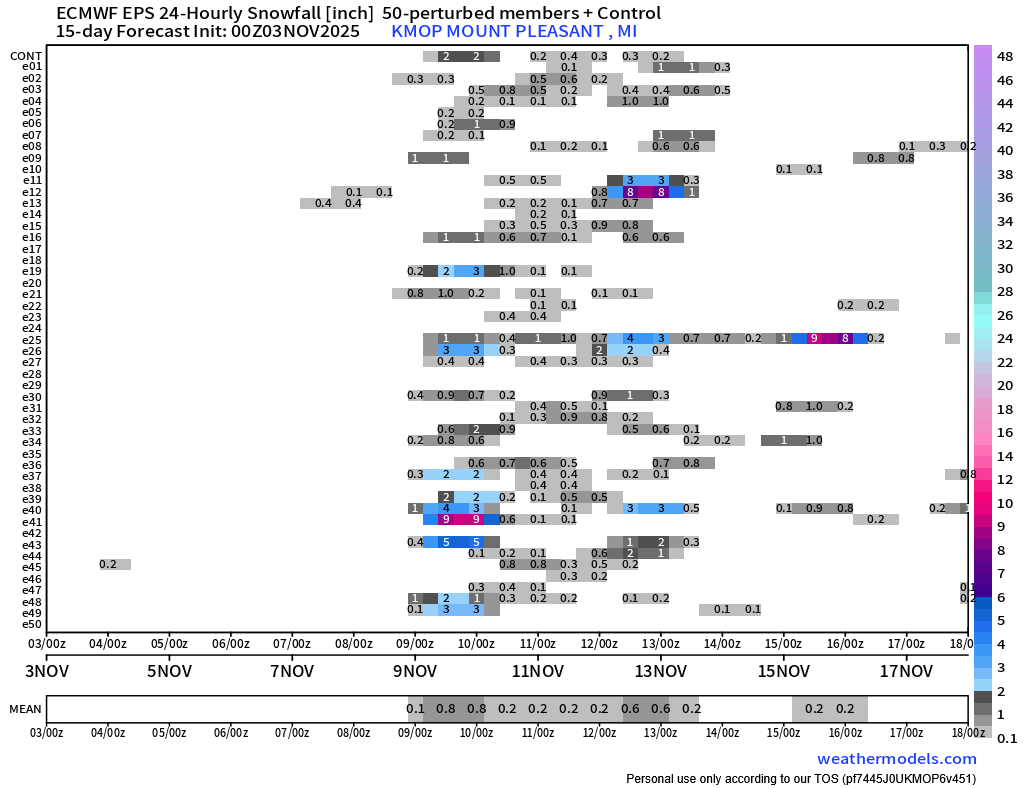
Past few runs of the EPS really trying to sell our first snow chcs of the season up here. Something to keep an eye on, fs


-

November 2025 general discussions and probable topic derailings ...
Typhoon Tip replied to Typhoon Tip's topic in New England
I've seen a lot more of these 12 to 15F differential mornings when comparing dawn temperatures between ORH and here in the Nashoba Valley than I normally do. It seems we are getting an anomalously large number of superb radiational cooling nights. That one factor appears to be over-achieving relative to "rational cooling night" climo - if there were ever a metric. It's just I've seen a lot more of these 12 to 15F differential morning comparing dawn temperatures between ORH and here in the Nashoba Valley than I normal due. Autumn is the time of year for that to happen, true. But lost count -

November 2025 general discussions and probable topic derailings ...
dryslot replied to Typhoon Tip's topic in New England
Suck it up buttercup. - Today
-
Wizards done... Capitals done
-
looks like a solidly above normal month ahead. Not by a lot, but it won’t be close to normal. New normal old normal whatever. if I still have my outdoor shower going at the beginning of November with no end date in sight, that’s a warm intro to winter
-

2025-2026 ENSO
40/70 Benchmark replied to 40/70 Benchmark's topic in Weather Forecasting and Discussion
@Stormchaserchuck1 What was your final NAO number? -

November 2025 general discussions and probable topic derailings ...
dendrite replied to Typhoon Tip's topic in New England
Yeah I’m ready for it to start warming up. I’m already sick of winter. lol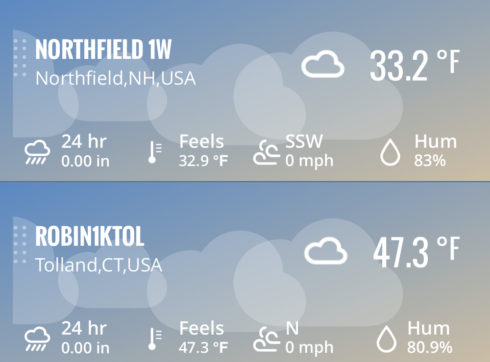
-
2025-2026 ENSO
40/70 Benchmark replied to 40/70 Benchmark's topic in Weather Forecasting and Discussion
I've been anticipating a -1 to -1.2 peak RONI, -
 41.4
41.4 -
Sep 17th through Nov 3rd highest ACE back to 1851 based on tracks on record and my ACE calculations/estimates: 1878: ~105-110 1894: ~100-110 2025: 94 1893: ~89 2017: 88 2024: 86 2016: 85 2005: 85 So, 2025 had the highest Sept 17th-Nov 3rd ACE since 1895 and the 3rd highest on record! Sept 17th-Nov 3rd ACE 2025-2010: 2025: 94 2024: 86 2023: 42 2022: 58 2021: 64 2020: 70 2019: 58 2018: 45 2017: 88 2016: 85 2015: 32 2014: 36 2013: 7 2012: 44 2011: 45 2010: 51 ————— Edit: As we move forward through the rest of the season and look at Sept. 17th+ ACE, these seasons would overtake 2025 if it has no more ACE: 1932, 2005, 2020, and 2024 with 1893, 1896, and 1961 coming very close.
-
That's great about Jay. I believe they are on the Idny pass, so I'll prolly be making a couple trips this winter. I got the IKON and Indy this season. I'd like to go to Japan this winter. Anyone been there? Any recommendations?
-
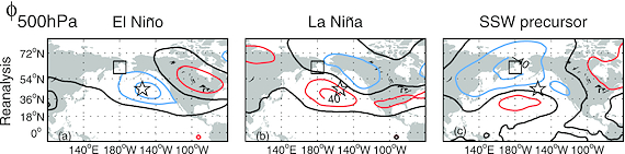
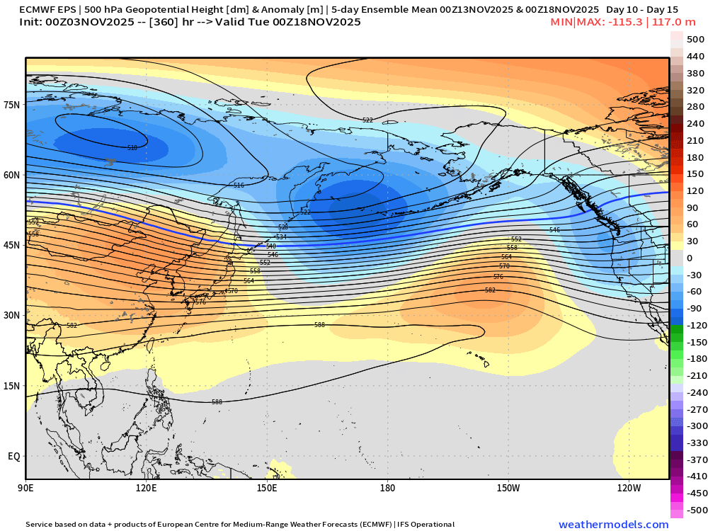
There are perhaps some clues to keep an eye on in the context of this. As whatever happens higher up in the atmosphere is strongly tied to the progression in the troposphere. Namely, keep an eye on what transpires in the north Pacific. There's a great paper on these events and why they occur in both el nino and la nina. I'll post below figure 1 from this paper along with the explanation given for the image. Also of note, some of the recent ensemble runs have been showing some similarities to the precursor 500mb later in the runs. I'll add the 00z EPS from last night after that for example. I suspect the amount of members achieving the ssw have been the ones with a deep north Pacific low in their progression in the proper location. Not saying one happens, only that there seems to be a valid reason for some of those members to be showing it. Why might stratospheric sudden warmings occur with similar frequency in El Niño and La Niña winters? https://agupubs.onlinelibrary.wiley.com/doi/full/10.1029/2012JD017777 Last nights 00z EPS - note this is a 5 day mean
-
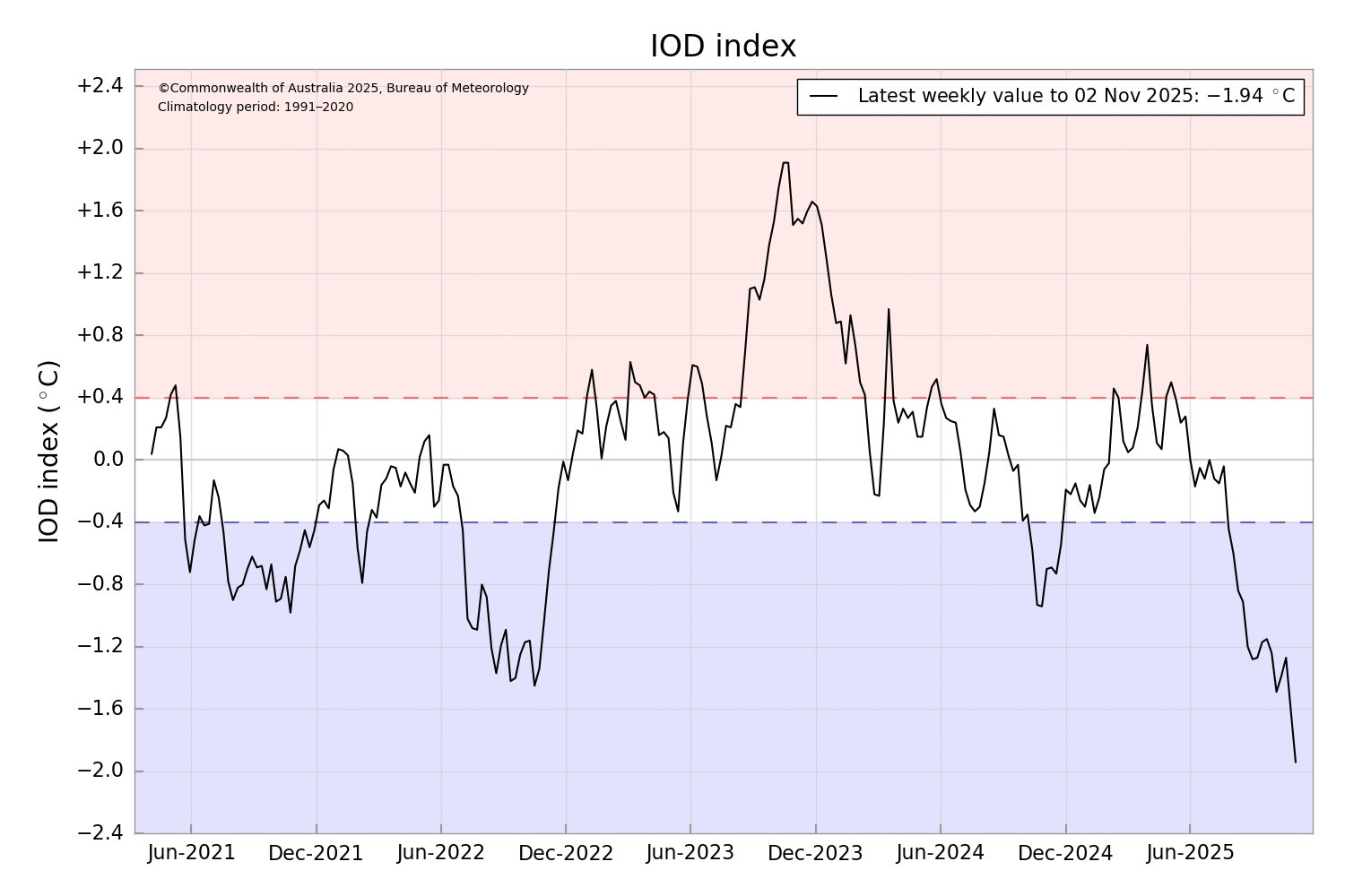
The Indian Ocean Dipole (IOD) has reached a new record weekly negative value at -1.94ºC. A negative dipole reduces convection across the west Indian Ocean and enhances it across the east. This can favour more blocked weather patterns. Sent from my SM-G998U using Tapatalk

-
I wrote about that back on September 9, either in this thread or somewhere. If this winter was going to perform - imho - it would more likely be an early blocking tendency and an early loaded affair. I may have even mused if memory servers, that it may not return post the canonical January thaw. February Lilacs. Low confidence at the time, mainly in deference to the fact that it was 2.5 months away... gee ya think. Anyway, so I don't have a problem with Webb's ideas there. In fact, the recent -NAO and low amplitude +PNA observed 7 to 10 days ago could really be argued as heralding that. ... and now we're doing it again ...with a new -delta( AO/NAO) emerging. As an aside, the problem with the recent temperatures ... there's some relativity going on doing a marvelous job at hiding the obviousness of a colder pattern. We're registering daily averages that range from +decimals to +2s in a pattern that would be -3s, 30 years ago. Compounding further, generational acclimation, colloquially referred to as 'boiling a frog' is putting us in a physical situation where we are now biased to feel a mere +1 is cold autumn, when in fact it is positive. I see these two distinct relativity's sort of moving past one another without much realization that either is happening in ambit discussion ... interesting. Back here on Earth, as snow enthusiasts, ... we may want to watch the 10-13 period of time. Mentioned above, there's a new -D(AO/NAO) emerging in the ensembles, both in the spatial synoptics, but also numerically. The NAO component so far favoring the western limb of the domain, too. The correction vector is pointed S over mid latitude/E N/A. In simple terms, that means non-cutting lows and/or tending to correct S in the guidance over time. Meanwhile, there is sufficient cold/lower thickness spread out across S-SE Canada, due in part to antecedent SPV whirling over the E Canadian shield over the next week. So we'll see where that goes.
-

November 2025 general discussions and probable topic derailings ...
CoastalWx replied to Typhoon Tip's topic in New England
We just don’t know -
I think if you get the WH31E, you can purchase a shield for it and then sync it to the ws-2902 (or whatever you have) station. It won't show the temp from it on the console, but will on the app I believe. I don't have this, but am thinking about getting it now. Thanks Bluewave for the post. I have a shield for my thermometer now, but if I can get this one, and sync it to the app, it would much easier than clicking though 2 apps like I do now. edit: I just bought the WH31E from Amazon. It says it will be delivered today, so I'm going to try syncing this sometime this week.
-

November 2025 general discussions and probable topic derailings ...
weathafella replied to Typhoon Tip's topic in New England
Frost on the cars at 11pm last night. We step.


.thumb.jpg.ad3a2e31d30aff035044689b311a0540.jpg)