All Activity
- Past hour
-
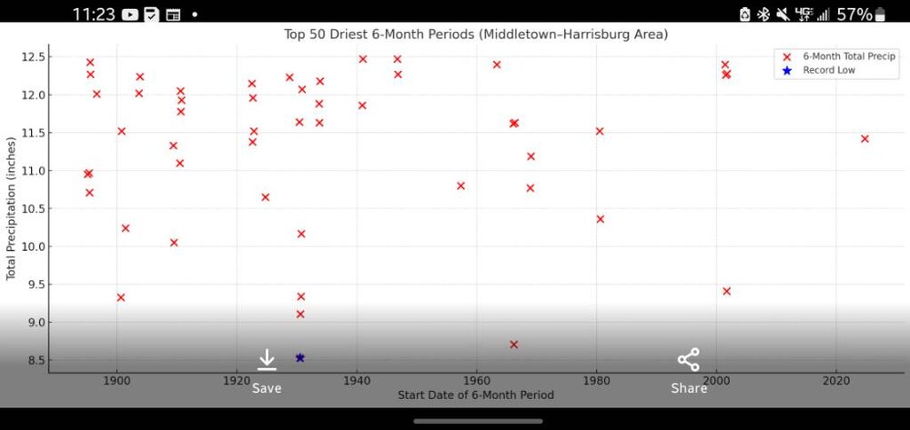
If this indeed turns out to be this year's nadir, I find that interesting - it'd be the earliest of all recent seasons, regardless of magnitudes, whence the nadir took place

-

September 2025 OBS-Discussion centered NYC subforum
Brian5671 replied to wdrag's topic in New York City Metro
wonder what's causing that cold patch off our coast? -
So... As we start to see all the " Hype factor " for this upcoming Winter.... A new one just popped up. It's the CFS model and it shows very cold air for December, January, and February for much of the Central and Eastern US. I'm just not sure if that is a reliable model or not ( at least compared to the other Global models ).
-

September 2025 OBS-Discussion centered NYC subforum
SACRUS replied to wdrag's topic in New York City Metro
Latest SST anomaly -
boy is this weather boring.....and fantastic. Could definitely use some rain. trails and streams are bone dry.
-
Top 50 6 month dry periods timeline Sent from my SM-G970U1 using Tapatalk
-
I just hope no rain this summer will not mean no snow this winter. It cannot go on forever? Maybe it can and the Earth, thanks to us (sorry little editorialization), is moribund and going to Hell in a handbasket, whatever. But I don't want to be on man-made snow all winter. East Coast crud, "packed powder," ice patches, dirt poking through. All adds to the challenge, but man, I want some powder! Don't make me shell out a couple month's pay to go out West, please. I can't really afford that this year, or usually, unless it's some business-related thing (rare for me of late). So, just give me a good ol' fashioned winter like with I ran the lifts at Mount Snow upon returned to New England from five years in San Francisco. It was 1996 - 1997, I believe, record snow year up til then. We were open from Halloween to tax day (six months). I got 150 fricken days snowboarding in--all day 8am - 4pm days off, five runs per day when I worked. I grew up going to that mountain since I was a kid in Boston/Mass. Give me more of that, please!
-
BOS with a massive torch yesterday … +0.6F. -2.2F MTD ORH was +3.8F. -1.2 MTD should begin to swing towards AN this week.
-
Seems like we wont' be getting anything meaningful from that pos system off the mid-atlantic either.
-
-Invest 92L has significant ACE potential (10-15+) with much of this coming from the subtropics -The active Euro Weeklies for 9/22-10/12 show absolutely no resemblance to the relative quiet of the season overall to this point
-
It may never rain again.
-

September 2025 OBS-Discussion centered NYC subforum
anthonymm replied to wdrag's topic in New York City Metro
Are you seeing September finish above normal for the park? I'm seeing a lot of muggy nights (almost 70 degree overnight lows!) in the upcoming week, which should erode the cooler start totally. - Today
-

September 2025 OBS-Discussion centered NYC subforum
bluewave replied to wdrag's topic in New York City Metro
The source region to our west has been record dry since August 1st. -
GYX mentioned 20s/low 30s in the north part of their CWA, though they also cautioned that it's 5-6 days away. Yesterday was 4° AN here, first AN day since 9/6. Low of 48 ended a 5-day run of 30s. Month is 1.6 BN so far.
-
September 2025 OBS-Discussion centered NYC subforum
Brian5671 replied to wdrag's topic in New York City Metro
Dry soil will only help the cause-imagine if we did not get that 1-3 inches of rain last weekend -
We've had big area increases over the weekend, so pretty safe to call the area minimum now too at 2.7055 million sq km.
-
September 2025 OBS-Discussion centered NYC subforum
anthonymm replied to wdrag's topic in New York City Metro
Cold start to a month usually means blowtorch finish. It's very difficult to pull off BN months these days. I can see a huge -PNA ridge over the east to finish off the month. Probably upper 80s for everyone south of SNE. -
Looks like we could possibly see first frost this weekend for many up here away from the coast.
-
Warmth and boredom as far as the I can see. Hard to complain about a warm September though.
-

Occasional Thoughts on Climate Change
Typhoon Tip replied to donsutherland1's topic in Climate Change
As a Meteorologist with a turbo-dork cape, I can tell you that QRA is occurring at all spatial-temporal scales. Not just seasonal - I realize you're not suggestion so ... but I just think it is important to make the distinction. Individual stalled thunderstorm that dumps 10" of rain in a single afternoon is a harmonic/constructive interference event, at very small scale. The Pacific NW historic heat burst was a 10 .. 2 wk aspect in 2021, at perhaps intermediate. China, above, is more seasonal in scale involving a continent (altho I suspect the seasonal duration is an aggregate of intermediates in repetition, interruption by transient linear destructive interference suppressing the planetary scaled harmonics ... gets complex in a hurry) I believe it is important to understand that resonant feed-back is a phenomenon that should not be defined by lengths of existence. Its occurrence needs to be 'on the radar' (sorry for that pun) as a possible out of the blue general threat awareness. Synergistic emergence as a phenomenon is less constrained by spatial dimension - although smaller scaled ones do appear to have shorter ramp up times than those that affect at continental scales. This fits both the early climate-modeled warnings of a wide variance future, one that has also become objectively observed, too. As an aside ... I suspect there may be late October through mid December winter or quasi-winter loading patterns across N/A ( the severity and/or lengths of which are impossible to determine in seasonal predictions - just to be weary of them) Those would not necessarily go on to characterize the entire winter season ( DJF ). We can actually see this when objectively looking back at the last 20 years of climatology, too. Some of this idea is footed in recurrent observation of them, both objectively and subjectively increasing in frequency spanning climate recency. These so called 'cold meanders', some half the OND's since 2000 have hosted either snow or snow supporting synoptic, whence the ensuing (DJF) went on to banality. The latter because the hemispheric gradient in these latter months become compressed, speed up the goestrophic flow everywhere requires coherent emergence of more planetary scaled waves, a latter property emergence that can be entirely new compared to whatever has been occurring during the latter autumn and earlier winters. -
I sincerely hope it does end up <100. I’ve been directly significantly affected by 5 TS/H since 2016 and the US, overall, has been hit very hard. However, the two most recent Euro Weeklies means generate ~50 ACE over the next 4 weeks vs the 2005-24 avg of 40. If that were to verify, we’d be ~90 as of Oct. 12th with a high chance of reaching 100 by season’s end. For more details, folks can go to the Atlantic tropical thread if interested. *Edit: I forgot to mention the favorable for TCG MJO consensus forecast dominating at least for the rest of Sept
-
Need a tropical system which seems unlikely. No, I am not wishing for a Hurricane, but a nice tropical system to dump 3to4 inches would be nice. My plants around my house are looking pretty bad. I remember complaining about the non stop rain in June. The precip pattern is all or nothing.
-

2025 Atlantic Hurricane Season
WxWatcher007 replied to BarryStantonGBP's topic in Tropical Headquarters
I think the tropical Atlantic will continue to be a loss for activity, but I’ll want to see if waves survive the trek into the Caribbean and SW Atlantic after 9/20 or if the basin is just relying on CAG potential and stalled fronts. It’s easy to be prisoner of the moment, but the run up to the peak last year was historically inactive too…until the lid over the basin blew off. -
The Browns run defense is probably the best in the league. That's a nice win for the Ravens given how Cleveland drags teams into the mire. (obligatory reminder - Bengals fan here - so have decent perch to observe on all things AFC North)
-

September 2025 OBS-Discussion centered NYC subforum
jm1220 replied to wdrag's topic in New York City Metro
Yep, will probably hit 90 IMBY and maybe on the south shore if we keep the WNW flow going into the afternoon. Soil moisture is low which will help.


.thumb.png.4150b06c63a21f61052e47a612bf1818.png)


