All Activity
- Past hour
-
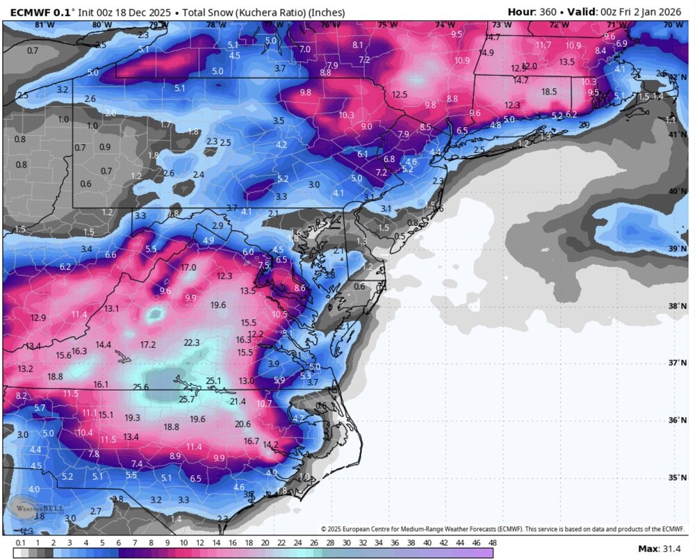
Christmas Day showers on the euro AI.
-

Central PA Winter 25/26 Discussion and Obs
pawatch replied to MAG5035's topic in Upstate New York/Pennsylvania
17 degrees this morning. No fog this morning, but I think all the road salt on the roads helped the black ice situation some. -

December 2025 regional war/obs/disco thread
Damage In Tolland replied to Torch Tiger's topic in New England
2-5” type deal Tuesday . That’s our shot -

Richmond Metro/Hampton Roads Area Discussion
Conway7305 replied to RIC Airport's topic in Mid Atlantic
I know it’s fantasy, but it’s nice to see the show up on the euro.. Maybe the pattern can flip back early January
-
No, just me ha ha.
-

December 2025 Short/Medium Range Forecast Thread
Carvers Gap replied to John1122's topic in Tennessee Valley
There will likely be some model chaos(and even real time chaos) w/ two strong and very opposite teleconnections IF they verify. The Aleutians Ridge and -NAO are not going to play well together. I suspect we end up w/ a very similar pattern to what we exited, but the pattern force south of where it was due to the NAO and seasonal climatology. It seems like the Yukon will be cold and will send cold air southeast into a suppressed storm track. I do think ridges will roll through between cold shots. But we roll the dice and take our chances if that is indeed the setup. Suppressed storm tracks with cold involved...we take. The nice thing is that most of the models are eliminating feedback over the Pacific Northwest, and we can see what is a reasonable pattern unfolding. Infinite Baja lows and Pac NW lows.... I guess the question I have now is if there is feedback w/ the Aleutians low and maybe the NAO? Those are two other areas where models will sometimes under-do and over-do things. -

December 2025 regional war/obs/disco thread
Sey-Mour Snow replied to Torch Tiger's topic in New England
So what you are saying is “No one’s ever seen anything like it”? -
Holiday period is looking exciting. Lots of s/w’s and clippers in the flow and repeating tracks. Someone might get a 1 2 punch within short order. LFG!
-
Yep, ice everywhere this morning.
-
December 2025 Short/Medium Range Forecast Thread
Carvers Gap replied to John1122's topic in Tennessee Valley
The -NAO is the story if it unfold the way modeling has shown it for the past 48 hours. I don't think it will mean a trough 100% of the time over the EC, but it "could" force the storm track well south as we have see on overnight runs. The 0z Euro and now 6z GFS.....what a turn of events. -
Yes it is... Torch no longer in the cards!!!
-

December 2025 regional war/obs/disco thread
moneypitmike replied to Torch Tiger's topic in New England
That will be one thick pack of ice when it refreezes. -

Occasional Thoughts on Climate Change
donsutherland1 replied to donsutherland1's topic in Climate Change
Arctic sea ice extent (JAXA) has demolished the old record for lowest start to December. That record was set just last year.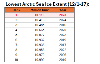
-
December 2025 regional war/obs/disco thread
moneypitmike replied to Torch Tiger's topic in New England
Enjoy the last day of snow today. There's still about 4"......bare lawn tomorrow afternoon. At least we have this. Friday Rain and possibly a thunderstorm before 2pm, then rain likely. High near 56. Windy, with a south wind 20 to 29 mph, with gusts as high as 55 mph. Chance of precipitation is 100%. New rainfall amounts between a half and three quarters of an inch possible. -
Weeklies saying we have to wait doesn’t mean I was waiting
-
Yikes, current P&C has about 1.5” of rain for tomorrow. Keeps going up
-

2025-2026 Fall/Winter Mountain Thread
nchighcountrywx replied to Buckethead's topic in Southeastern States
-
Already have seen this same retrogression of said ridge axis 2 other times in the past couple of weeks. LR ridge in OV ends up verifying out in the Western Plains/Eastern Rockies. Nice to see.
-
December 2025 regional war/obs/disco thread
moneypitmike replied to Torch Tiger's topic in New England
That image screams for this. -
Ridge keeps backing up west!!!
-
Literally yesterday some of you were talking about waiting until the back half of January lol
-
As long as we're not in the orange or red lol
-
6z gfs showing a little bit of everything for that period. It will be interesting to see how this evolves or not.
-

December 2025 Short/Medium Range Forecast Thread
Holston_River_Rambler replied to John1122's topic in Tennessee Valley
Interestingly both GFS AI and Euro AI both almost look like ensembles for the same period. Since they are machine learning models using (presumably and I could definitely be wrong) the continuity of typical patterns, I wonder if the AI models skew less amplified in the longer range, since dramatic and amplified events are somewhat rare? Would this make the AI models less useful in the medium to longer ranges until they have ingested more datasets of times where large blocks are "bullying" (quoting griteater) the pattern? How many significant, blocky patterns have wee seen since we started running AI models to give them datasets? I would say not many over the regions depicted below, but don't often look at blocky patterns anywhere else, so there could be some confirmation bias at play. -

Central PA Winter 25/26 Discussion and Obs
mahantango#1 replied to MAG5035's topic in Upstate New York/Pennsylvania
URGENT - WEATHER MESSAGE National Weather Service State College PA 147 AM EST Thu Dec 18 2025 PAZ004>006-010>012-017>019-026>028-035>037-041-042-045-046-049>053- 056>059-063>066-190915- /O.NEW.KCTP.WI.Y.0016.251219T0600Z-251220T0600Z/ Warren-McKean-Potter-Elk-Cameron-Northern Clinton-Clearfield- Northern Centre-Southern Centre-Huntingdon-Mifflin-Juniata-Fulton- Franklin-Tioga-Northern Lycoming-Sullivan-Southern Clinton- Southern Lycoming-Union-Snyder-Montour-Northumberland-Columbia- Perry-Dauphin-Schuylkill-Lebanon-Cumberland-Adams-York-Lancaster- Including the cities of Selinsgrove, Ridgway, Lewisburg, Coudersport, Wellsboro, Mount Union, Renovo, St. Marys, Huntingdon, Trout Run, DuBois, Harrisburg, York, Mansfield, McConnellsburg, Mifflintown, Williamsport, Berwick, Lebanon, Emporium, Gettysburg, Hershey, Sunbury, Pottsville, Clearfield, Philipsburg, Chambersburg, Lock Haven, Warren, Newport, Danville, Bloomsburg, Shamokin, Lancaster, Bradford, Carlisle, Laporte, Lewistown, and State College 147 AM EST Thu Dec 18 2025 ...WIND ADVISORY IN EFFECT FROM 1 AM FRIDAY TO 1 AM EST SATURDAY... * WHAT...West winds 15 to 25 mph with gusts up to 50 mph expected. * WHERE...Central Pennsylvania. * WHEN...From 1 AM Friday to 1 AM EST Saturday. * IMPACTS...Gusty winds will blow around unsecured objects including holiday decorations. Tree limbs could be blown down and a few power outages may result. PRECAUTIONARY/PREPAREDNESS ACTIONS... Use extra caution when driving, especially if operating a high profile vehicle. Secure outdoor objects.