All Activity
- Past hour
-

“Cory’s in NYC! Let’s HECS!” Feb. 22-24 Disco
The 4 Seasons replied to TheSnowman's topic in New England
80s in the east, 70s in the west? -

“Cory’s in NYC! Let’s HECS!” Feb. 22-24 Disco
Baroclinic Zone replied to TheSnowman's topic in New England
SREfs are sick. -
-
2/22-23 "There's no way..." Storm Part 2
Imgoinhungry replied to Maestrobjwa's topic in Mid Atlantic
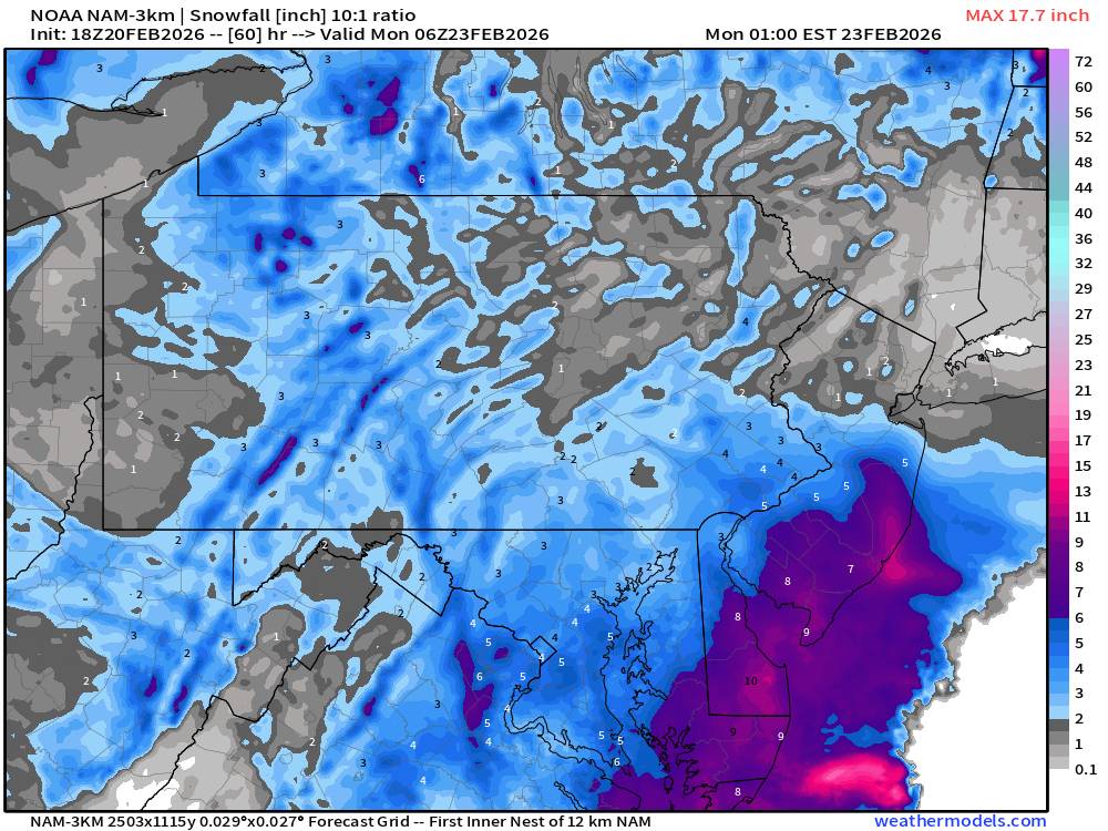
Would snow depth maps be a better use for this storm? Cut the accumulations on the 10:1 maps in half for this event? Or would that be over doing it? . -

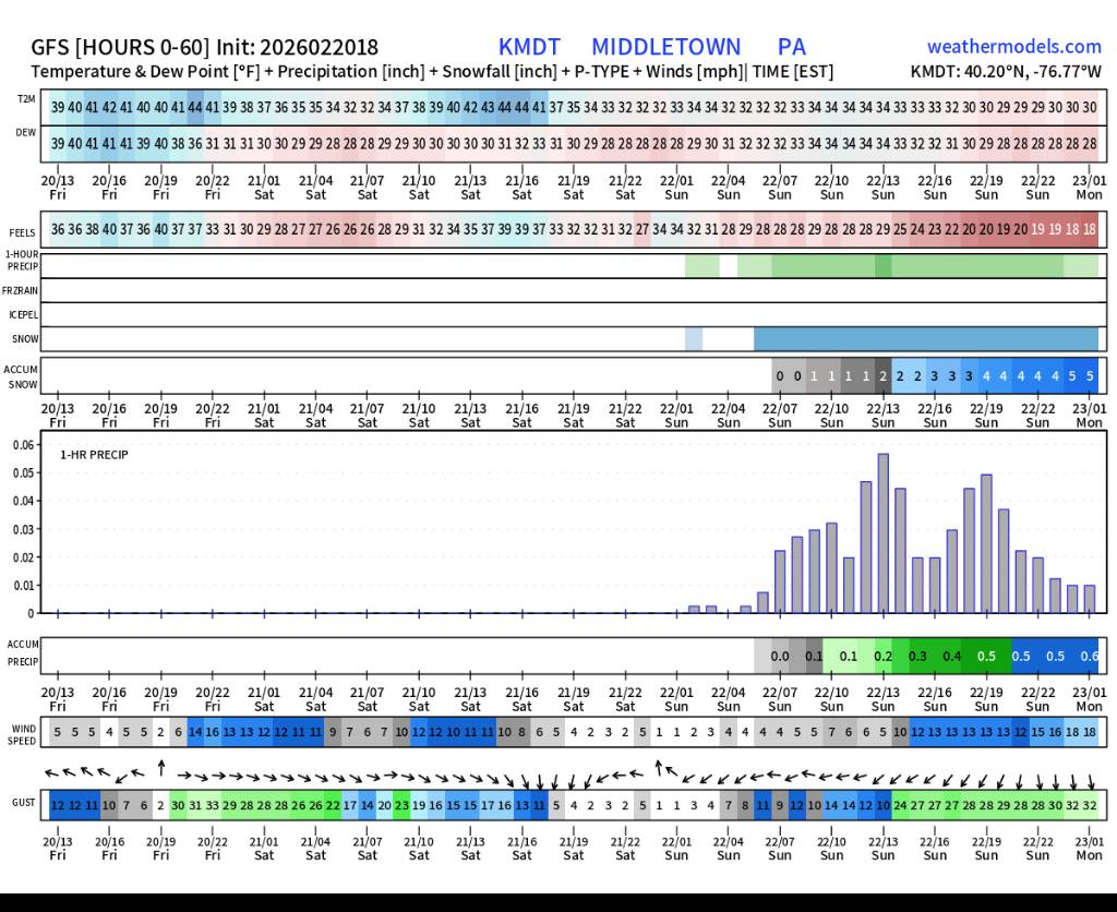
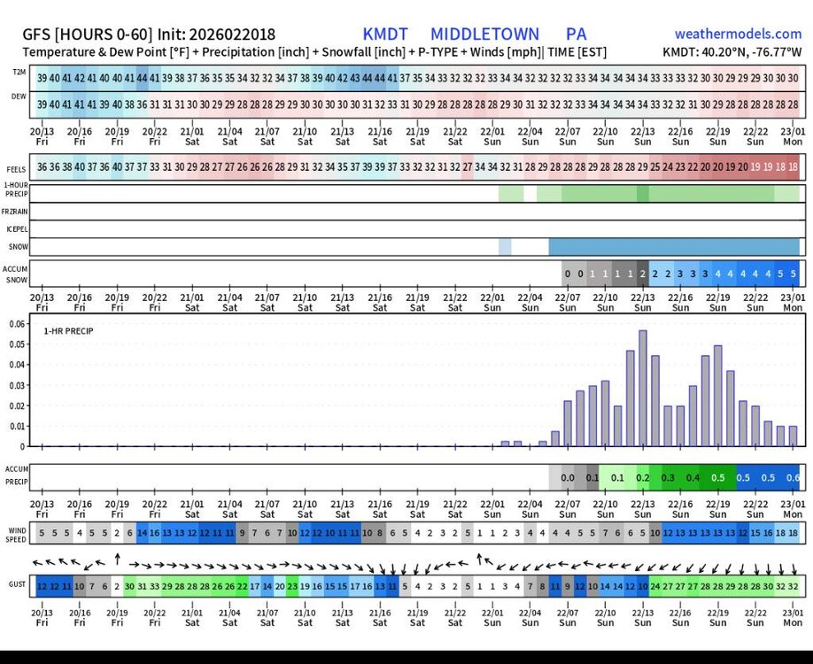
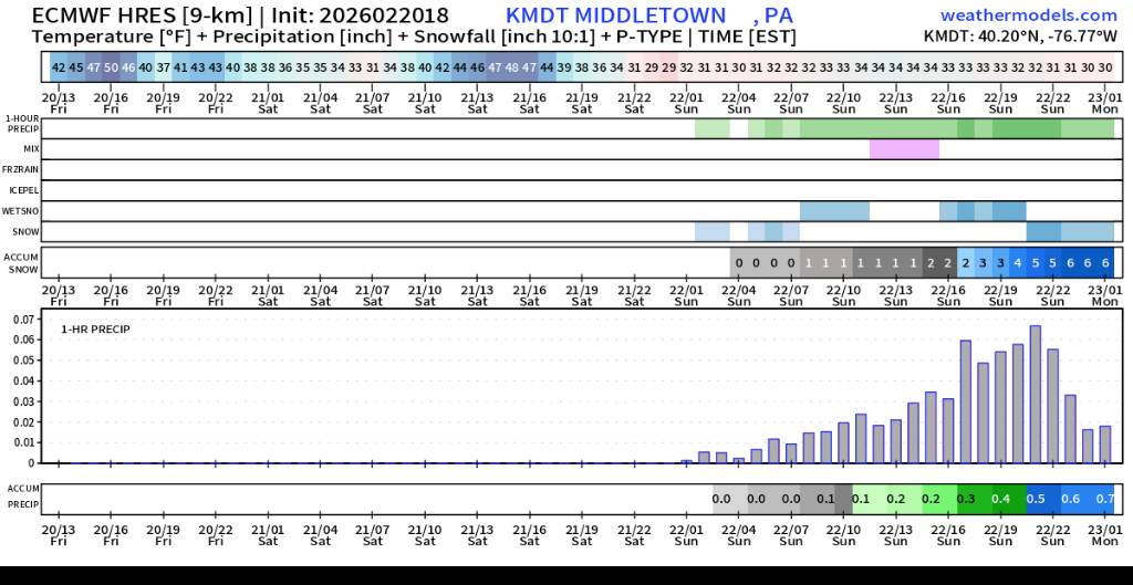
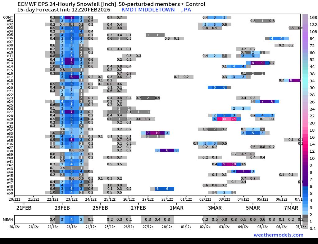
Central PA Winter 25/26 Discussion and Obs
Jns2183 replied to MAG5035's topic in Upstate New York/Pennsylvania
2/3 Sent from my SM-S731U using Tapatalk.thumb.jpg.4a28497c09b9192b436c1b2492004a0d.jpg)
-
Not speaking of the NBM specifically, but rather ratios in general- some of the modeled soundings show very impressive vertical lift(omega) through the DGZ with surface temps at 32 over this way at certain points in the storm- how high could the ratios be in that scenario? 15-1 maybe?
-
Ok ok ok let’s not go too far down this path. Back to weather.
-

2/22-23 "There's no way..." Storm Part 2
IUsedToHateCold replied to Maestrobjwa's topic in Mid Atlantic
I believe In a storm I felt was going to be a hit a week ago In a storm nobody thought was possible In a Nat 20 out of nowhere In models that are trending in the right direction for once In a chance for an HECS 00z is when we're going to reel it in. @bncho's riveting pbp Bring it home. -
Central PA Winter 25/26 Discussion and Obs
Jns2183 replied to MAG5035's topic in Upstate New York/Pennsylvania
Enjoy Sent from my SM-S731U using Tapatalk
.thumb.jpg.02f155737a320bcb17e85b2009941747.jpg)
-
“Cory’s in NYC! Let’s HECS!” Feb. 22-24 Disco
The 4 Seasons replied to TheSnowman's topic in New England
Finally something trended our way for a change. The Feb 1 costal, the Feb 15 coastal all had plenty of potential and enough cold air to work with but it all just couldn't come together. When you roll the dice enough times you're bound to hit -

“Cory’s in NYC! Let’s HECS!” Feb. 22-24 Disco
snowman21 replied to TheSnowman's topic in New England
Nah the GFS is too old for him. -
Correct. Whatever hundredths of QPF we lose to a mix won't matter once the storm gets going.
-
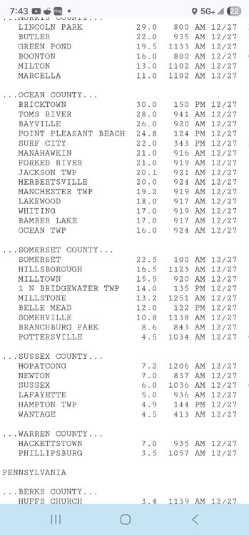
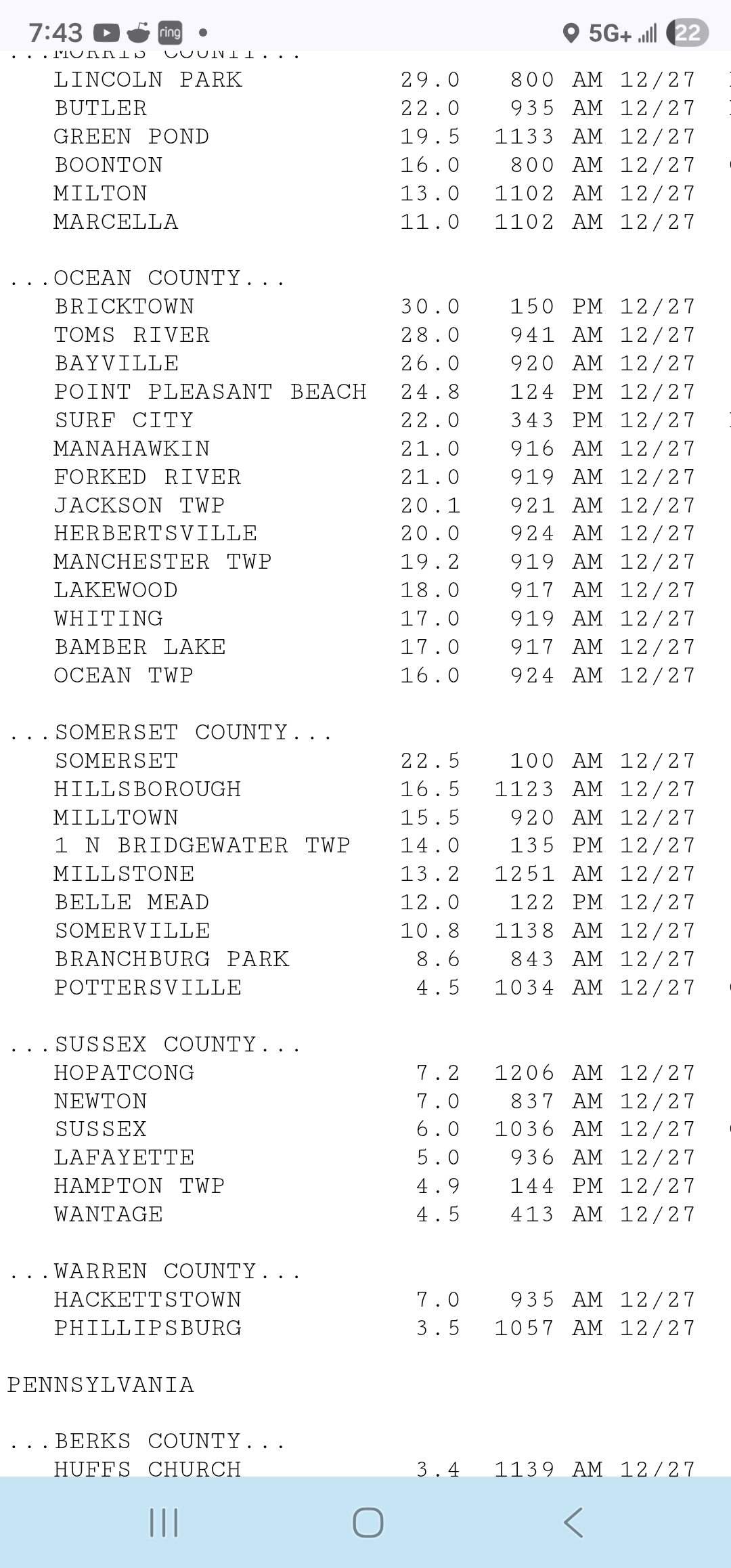
There has been officially 30"+ in NJ. Boxing Day storm was one and so was January 1996. I think probably the most recent was January 2016. Had 31" in southeast Morris County.
-

“Cory’s in NYC! Let’s HECS!” Feb. 22-24 Disco
RUNNAWAYICEBERG replied to TheSnowman's topic in New England
All the SA victims agree. -

“Cory’s in NYC! Let’s HECS!” Feb. 22-24 Disco
mahk_webstah replied to TheSnowman's topic in New England
Are you saying that the srefs are corrupt? -
“Cory’s in NYC! Let’s HECS!” Feb. 22-24 Disco
mahk_webstah replied to TheSnowman's topic in New England
With him, all in isn’t very far. and neither is that 1” contour! -

“Cory’s in NYC! Let’s HECS!” Feb. 22-24 Disco
WxWatcher007 replied to TheSnowman's topic in New England
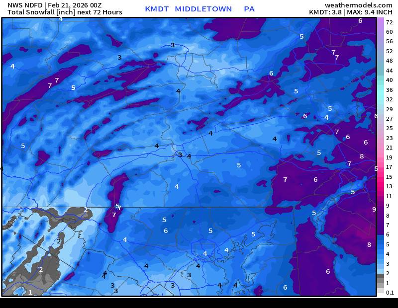
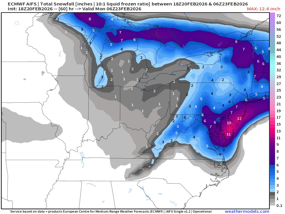
First call map. Most in the east, least in the west (and my backyard in the CT River Valley) -
Highest recorded snowfall by me in Montville, NJ (Morris County, NJ) was about 27 inches in the March 2018 storm. Would love to experience that again. And a fun fact…there has never been 30 inches of snow ever officially recorded in NJ. 29.7 is the record in 1947. Do you think we will ever see 30+ inches, especially with today’s seemingly deeper strengthening storms? .
-
So he went from saying the euro showing nothing for 3 days was right and the gfs was wrong. But the euro is still right and the gfs is still.wrong but tosses in a 4-8"? Yeahhhhh.....
-

February 22-23 Storm Thread/OBS
Violentweatherfan replied to Mikeymac5306's topic in Philadelphia Region
I highly recommend that Joe and Joe weather show on YouTube right about now -
I don't think the rain at the front end is about a close approach. It's about a marginally cold airmas coupled with light precip.
-

Central PA Winter 25/26 Discussion and Obs
Mount Joy Snowman replied to MAG5035's topic in Upstate New York/Pennsylvania
It's a totally fair concern. I would add that mixing issues through the first part of the storm have showed up on a number of models. The surface temps are marginal and really don't crash until the coastal gets ramping, so the question becomes how much qpf do we lose on the front end to mix or an inability to efficiently accumulate on surfaces. All valid concerns. Bottom line, as you said, be prepared for anything. Isn't that what makes this all fun anyway? Cheers! -

“Cory’s in NYC! Let’s HECS!” Feb. 22-24 Disco
moneypitmike replied to TheSnowman's topic in New England
At the point that I'm full-time in Mattapoisett, it will never snow there again. I'll become Cory 2.0. -
Jan 2016 dropped 33” at my house in Chester; I’m all in on this one. Let’s friggen get it! Edit: You never want to touch the money, but the trends on this, for all models over the past 24, I’m sold.
-
Only need gusts to at least 35 for 3 consecutive hours. There's a visibility parameter as well. That's why there can be blizzard conditions without a cloud in the sky.

.jpg.27d153dc7275c911651a0463d2e9a387.jpg)


.jpg.2f1d5d4c48a04d335efce584072265b4.jpg)