All Activity
- Past hour
-
I think they are thinking low 90s, not what the models are printing out. When I told a few that we could have a few days over 100 they didn’t believe me. But if the dews are also high, that will really cause power issues, if it is a drier heat, we should be able to handle it. I do see schools that are still in session closing though (although this is a good lesson as to why they should stick to a normal school year if their buildings are not air conditioned and not go until the end of June, but I digress).
-
They had it. Stein here. You only got like .2 anyways.
-
Always appreciate your posts. We think alike often. That's either awesome or some scary S lolol. I'm pretty sold on the CFS monthly ideas in the high latitudes. Fits the "blocking is back for a stretch" weird multi decadal pattern that I personally think is real. It's not a predictable cycle like others but it does wax and wane in 8-12 year cycles. Problem with prediction is you only know its flipped in the rear view and there are plenty of odds and ends that muddy it up. I've seen enough last couple of years to feel oddly confident this winter will feature some really nice looks. But if we're all being honest, storm tracks just aren't what they used to be. Imo- it's no fluke it's hard AF to get normal stuff underneath us in a clean way... even with good looks. You could say the east is due for a run of traditional noreasters but again, muddy odds and ends are persistently and consistently stabbing us right in the heart. Random? I hope so but idk... Intuition doesn't feel like it is...
-
0z Euro has 6 days in a row of over 100 degrees in NYC. We're all gonna die
-
Hopefully just your laptop
-
That’s very true. I think people are just looking for a pattern change. I know my lawn is super green but getting red thread and other fungus now that it has been so wet and dark.
-
.43 of rain since Sunday am in Marysville. Light mist continues now.
-
Yeah nothing had this
-
How many will perish ?
-
I am not sure they will be excited when the power goes out. Give me mist any day over that. Plus no one is truly excited about heatwaves if they go from AC to AC and they out of their way to avoid experiencing it.
-
More light rain overnight (0.18") and 5.17" so far for the month. Everything is sloppy and overgrown but fortunately we haven't experienced anything like those poor folks in Morgantown/Fairmont.
-
If it really does go over 100 I could see real problems with the power grid. It’s heat we haven’t had in a few years and everyone’s been used to this Seattle weather. But there are plenty of ways it could still trend to run of the mill.
-
I had the same thought over this way, another .65” overnight. I wasn’t expecting that much.
-
0.14” overnight 0.97” since Saturday
-
This is the best easy summer for rain in a long time IMBY. My garden looks like it is on steroids.
-
Man, let’s Hundy next week.
-
What rain?
-
Talking to some people on the train today and everyone is super excited about a heatwave, even the people that hate the heat. I found that odd but I think everyone is just sick and tired of the constant dreary weather we have had. Constant October skies in May/June do mess with emotions.
-

June 2025 discussion-obs: Summerlike
LongBeachSurfFreak replied to wdrag's topic in New York City Metro
It’s going to a complete shock to the system going from cool drizzle to a potentially historic heatwave. -
4 days with rain in a row.
-
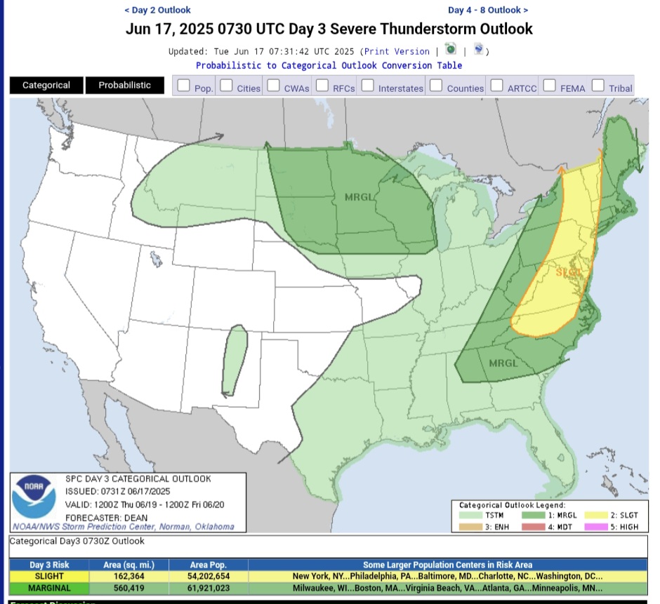
Scattered thunderstorm development will be possible along/ahead of the front from the Carolinas/Mid Atlantic into New England during the afternoon. Wind fields will generally be stronger with northward extent. Depending on the extent of destabilization, supercells and organized clusters will be possible across parts of New England and perhaps the northern Mid Atlantic, which would pose some threat of all severe hazards. Farther south into the southern Mid Atlantic and Carolinas, deep-layer shear will be weaker, but favorable low-level moisture, strong buoyancy, and modest midlevel southwesterlies will support outflow-driven clusters capable of damaging winds and possibly some hail. The organized severe threat will tend to decrease with southwestward extent, due to weaker deep-layer flow. However, favorable low-level moisture and buoyancy could support a few strong to locally severe storms along the trailing cold front into parts of the Southeast during the late afternoon and evening
-
Foggy and misty this morning.
-
On Monday of next week we will be asking for these days back lol
-
61, dreary and.....raining..again
-
Not sure I've ever seen that map. That's pretty cool. Or hot in this case.


.thumb.JPG.418e8a9a2902ae687ec35ff4bc0e038e.JPG)


.thumb.jpg.6a4895b2a43f87359e4e7d04a6fa0d14.jpg)