All Activity
- Past hour
-
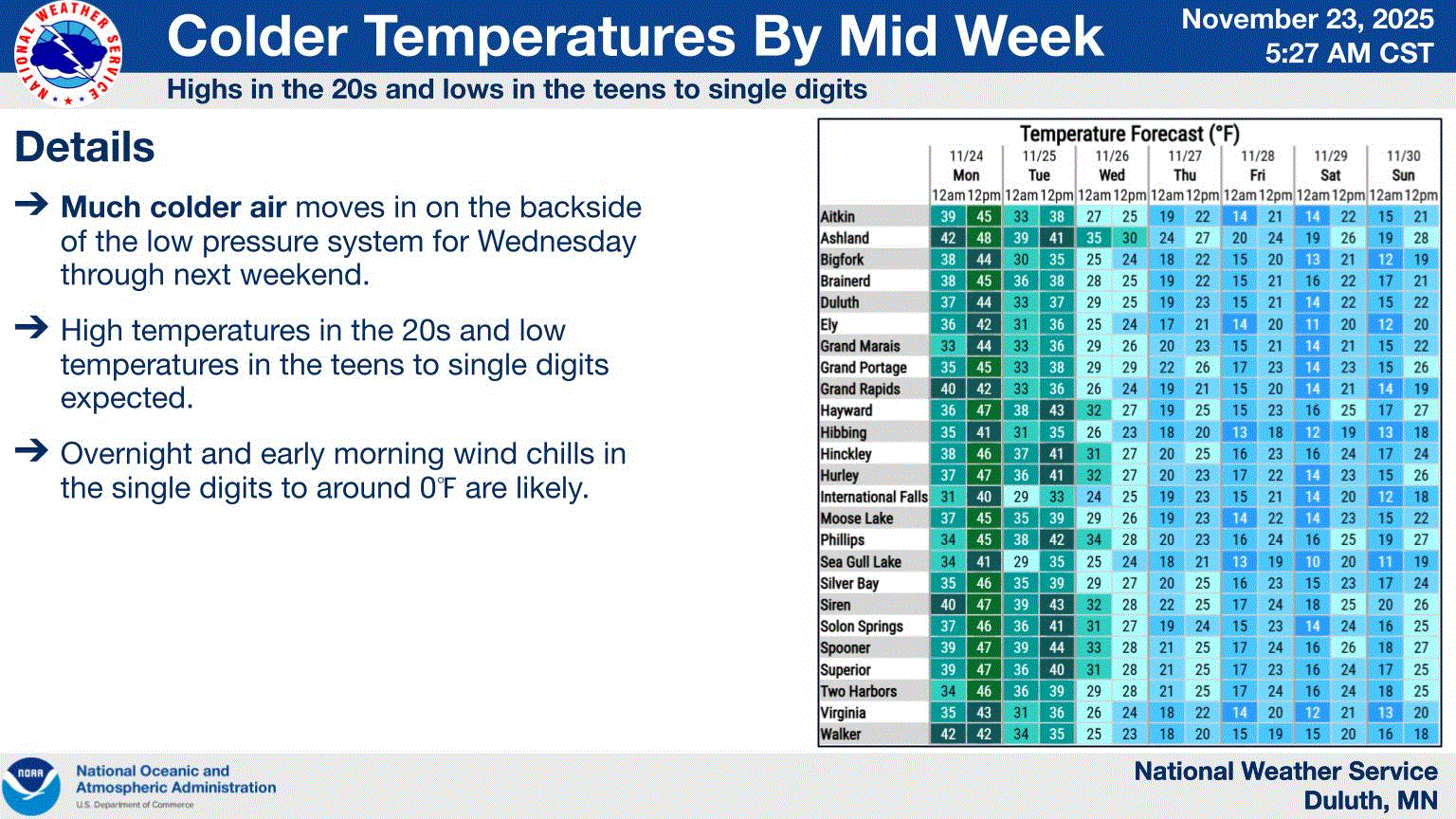
Judging by the flip flopping some things never change with the models. Everyone take a breath, it’s not even Thanksgiving. We’re going to be fine. Dec looks volatile and then we have Jammin’ January and Fab Feb.
-

2025-2026 ENSO
michsnowfreak replied to 40/70 Benchmark's topic in Weather Forecasting and Discussion
People post from different regions so different effects are expected. Plus the select group of posters who always/only look for warm will be looking and scouring social media for whatever they need to to mitigate any cold. But overall appears that in typical nina fashion, the already cold north will have colder anomalies and the already warm south warmer ones. In other words, big temp gradients at least at times. -

November 2025 general discussions and probable topic derailings ...
WinterWolf replied to Typhoon Tip's topic in New England
Wrong! So WRONG. What’s being progged is nothing like last December. -
It actually went below freezing in east Queens this morning instead of scraping just above it like we have had several times already.
-
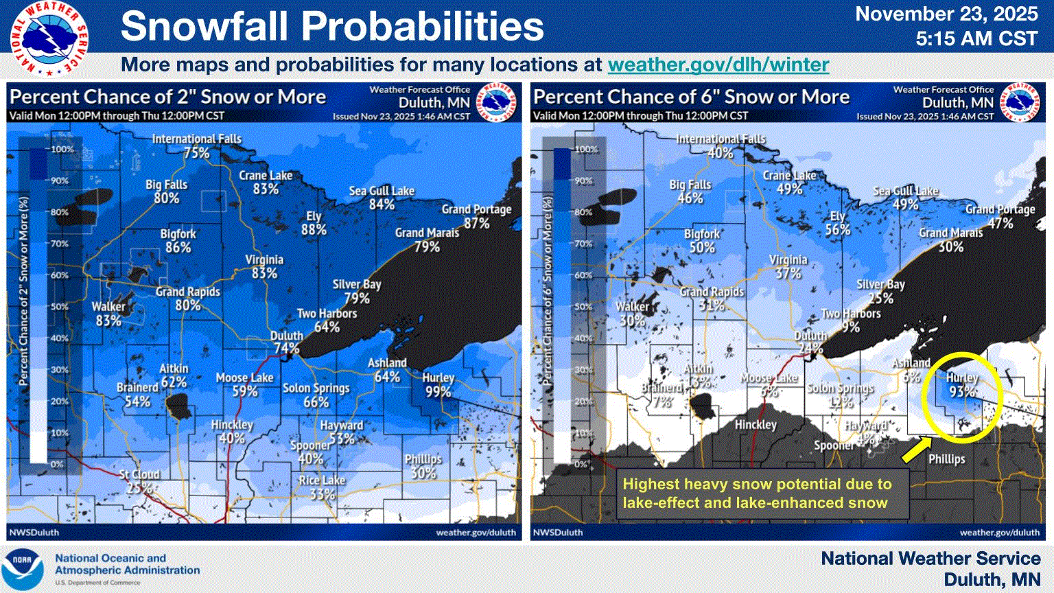
Looks like 3-6" potential starting tomorrow night. Followed by a decent chill for late Nov.
-

November 2025 general discussions and probable topic derailings ...
SnoSki14 replied to Typhoon Tip's topic in New England
It's been pretty much the same winter pattern for the last decade minus a few blips here and there. -
 How do you even know that ?
 -
It feels that way. Same ole garbage pattern locked in for years. At least I got to experience an amazing winter stretch from 2000-2018
-
Really need to stave the expectations. The long range looks decent/temps around climatology. Which aren’t the greatest for snow, ( 12-4 12-5 really spoiled us back in the day). The way things are these days I call that a win, I love Christmas, and I absolutely hate one where I’m wearing a T-shirt and hopefully that’s not the case this year. It can be bone dry and cold and I’d be happier than a pig in shit.
-
It was the coldest of the season so far here this morning as well -- I got down to 26. I still had some leaves on a couple trees in my yard, but the hard freeze this morning knocked the rest of them off. I'll do the final leaf cleanup tomorrow.
-
All the ensembles bring down the cold after the first week. No clue what the panic is right now.
-
Got down to 30. It was super frosty morning!
-

Central PA Fall Discussions and Obs
canderson replied to ChescoWx's topic in Upstate New York/Pennsylvania
You can’t give a head coach a 2 year deal in football. It’s suicide. -

Central PA Fall Discussions and Obs
pawatch replied to ChescoWx's topic in Upstate New York/Pennsylvania
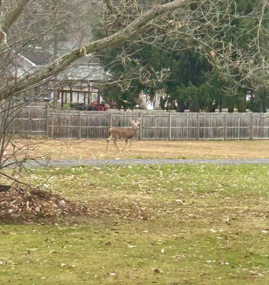
Buck trailing a doe.

-

November 2025 general discussions and probable topic derailings ...
dendrite replied to Typhoon Tip's topic in New England
Maybe some periods of steady snow this afternoon north of rt2 with coatings in spots? Mitch is still 26°. -
 We 6z Euro AI..seems pretty aggressive pushing that cold southward
 -
Nov 23, 1989 Thanksgiving Snowstorm
-

Central PA Fall Discussions and Obs
WmsptWx replied to ChescoWx's topic in Upstate New York/Pennsylvania
Which is why I would give Smith two years max. With the Portal and NIL, you no longer have to give a new coach an entire recruiting cycle to build a team. Theoretically speaking Smith would mitigate or minimize the exodus to Blacksburg and that's even if the kids planning to join the used car salesman haven't already discovered he's entirely full of shit. That alone is reason enough to consider a short term deal. He said something very very concerning last night at the presser in that Penn State is going to win games and lose games and will win more than they lose. That likely sticks and will come up as to why he may not be hired. Penn State doesn't want to lose games. Even being a realist, you're going to be spending the money to win everything, right now, all the time. His bit of realism may have sunk him. -

Central PA Fall Discussions and Obs
Mount Joy Snowman replied to ChescoWx's topic in Upstate New York/Pennsylvania
Low of 32. Not gonna lie, Terry rockin the 409 pin had me in some kinda way. With that said, I stand by what I said last night, that it would be unwise to make an emotional hire based on what we’re all feeling at the current moment. -

2025-2026 ENSO
donsutherland1 replied to 40/70 Benchmark's topic in Weather Forecasting and Discussion
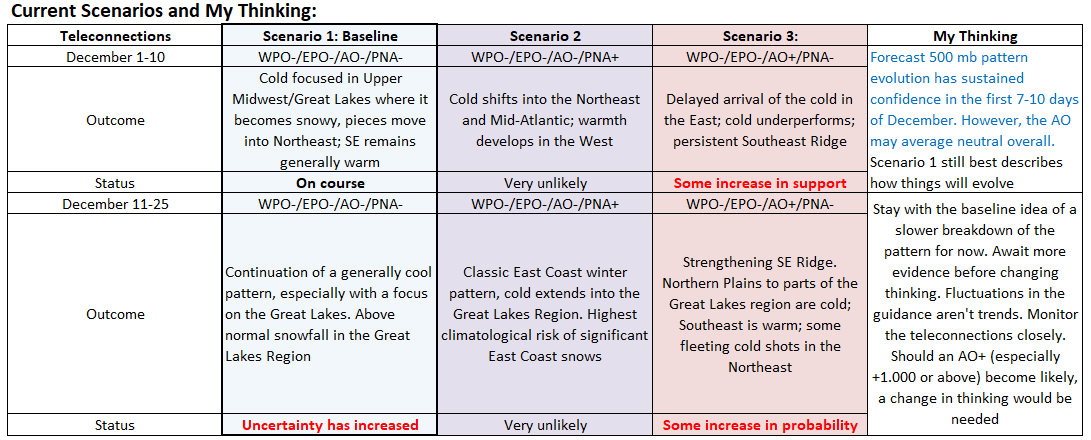
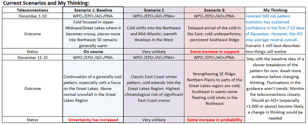
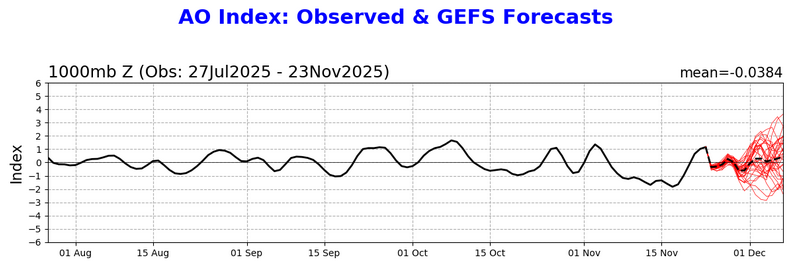
The CFSv2 has now moved into the early stages of its skillful range. Its monthly forecast for December is below. I assessed this idea against the currently expected state of the teleconnections. ENSO was omitted, as the sample size became so small that is was useless (n=2). Based on the expected predominant state of the teleconnections for December (WPO-/EPO-/PNA- and AO neutral) it appears reasonable. The AO should start negative but could go positive as December progresses based on the current guidance. The second half outcome will depend on whether or not the stratospheric warming event propagates to the troposphere to promote a redevelopment or persistence of AO blocking. So, for purposes of conservatism, I treated the AO as neutral (monthly average above -0.50 but below +0.50) for looking at the monthly CFSv2 idea. Should an AO+ regime develop (SSW fails to propagate in a fashion that promotes AO blocking), warm anomalies could cover much of the Eastern Seaboard with the exception of central or northern New England and have the risk of spreading into at least the Ohio Valley and perhaps farther westward depending on the strength of the AO+. For now, this is an identified risk, but not the most likely outcome. On the other hand, should strong AO blocking develop, most of the eastern half of the U.S. would likely see cold anomalies. This scenario would also have the highest probability of seeing a strong Arctic outbreak reach the East Coast. Given the present guidance, this seems to be less likely than an earlier breakdown of the AO-. But the stratospheric warming event is a wildcard and how such events ultimately play out over long timeframes is not a high-skill undertaking. It should also be noted that teleconnections cannot be forecast skillfully beyond 10-14 days. All in all, the combination of the CFSv2 and teleconnections highlights the Great Lakes Region and Upper Midwest as having the greatest probability of experiencing cold anomalies. They also highlight the Great Lakes Region as having the highest probability of above normal monthly snowfall. As for my thinking using the framework I illustrated yesterday, I've highlighted what has changed in my thinking overnight in blue. The emergence of a neutral AO on the guidance was noted (there's a very large spread among the ensemble members). No changes were made beyond December 10 as signals remain mixed and there remains no clear signal for a change.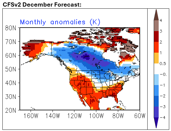
- Today
-
Records: Highs: EWR: 74 (1931) NYC: 72 (1931) LGA: 70 (1992) JFK: 71 (1992) Lows: EWR: 13 (2018) NYC: 14 (1880) LGA: 17 (2018) JFK: 15 (2018) Historical: 1880: Cool wave set three records lows for the date at WBO, 12° /22nd, 12° /23rd, 13°/24th. (Ref. Washington Weather Records - KDCA) 1909 - Rattlesnake Creek was deluged with 7.17 inches of rain in 24 hours to establish a record for the state of Idaho. (The Weather Channel) 1912: The Rouse Simmons was a three-masted schooner famous for sinking during a violent storm on Lake Michigan on this day. The ship was bound for Chicago with a cargo of Christmas trees when it foundered off the coast of Two Rivers, Wisconsin, killing all on board. 1931: A ridge across extending from the Midwest to the east and a trough out west spelled record temperatures. Grand Rapids, MI hit 70, their warmest on record for so late in the season. Other daily record highs included: Charleston, WV: 86°, Huntington, WV: 78°, Boston, MA: 77°, Tupelo, MS: 76°, Cincinnati, OH: 75°, Cleveland, OH: 75°, Knoxville, TN: 75°, Nashville, TN: 75°, Syracuse, NY: 75°, Hartford, CT: 75°, Akron, OH: 74°, Youngstown, OH: 74°, Newark, NJ: 74°, Rochester, NY: 74°, Worcester, MA: 74°, Columbia, MO: 73°, Springfield, IL: 72°, Indianapolis, IN: 72°, Columbus, OH: 72°, Beckley, WV: 72°, Elkins, WV: 72°, Allentown, PA: 72°, Avoca, PA: 72°, Pittsburgh, PA: 72°, Albany, NY: 72°, New York (Central Park), NY: 72°, Providence, RI: 72°, Philadelphia, PA: 72°-Tied, Peoria, IL: 71°, South Bend, IN: 71°, Toledo, OH: 71°, Harrisburg, PA: 71°, Chicago, IL: 69°, Detroit, MI: 69°. (Ref. Wilson Wx. History) 1943 - Northern New Hampshire was in the grips of a record snowstorm which left a total of 55 inches at Berlin, and 56 inches at Randolph. The 56 inch total at Randolph established a 24 hour snowfall record for the state. In Maine, Middle Dam received a record 35 inches of snow in 24 hours. (David Ludlum) 1960: The Tiros II weather satellite was launched. It recorded 25,574 photographs during its 10 month lifespan. (Ref. AccWeather Weather History) 1974: Bismarck, ND was in the middle of a 5-day snowstorm during which 28.3 inches fell, the greatest amount on record. (Ref. AccWeather Weather History) 1983: BA 24-hour snowfall record for Duluth, MN was broken with 16.9 inches. 19.7 inches fell during the entire storm, also a record. Ahead of the storm, high pressure brought record high temperatures from parts of the Great Lakes to the Tennessee Valley including: Montgomery, AL: 81°, Jackson, KY: 74°. (Ref. Wilson Wx. History) 1987 - Rain and gale force winds prevailed along the Northern Pacific coast. Quillayute, WA, received 1.57 inches of rain in 24 hours, including nine tenths of an inch in six hours. Heavy snow fell over northern Oregon and the Cascade Mountains of Washington State. Temperatures began to moderate in the eastern U.S. following a bitterly cold weekend. (The National Weather Summary) 1988 - Low pressure crossing the Great Basin brought wintry weather to parts of the western U.S. Up to a foot of snow blanketed Yellowstone Park, and winds gusted to 70 mph at casper WY, and reached 95 mph near Reno NV. Up to seven inches of rain was reported in the Grass Valley and Nevada City area of California. Paradise CA was soaked with 5.37 inches of rain in 24 hours. (The National Weather Summary) (Storm Data) 1989 - Low pressure tracking across the Carolinas brought heavy rain to parts of the Southern Atlantic Coast Region for Thanksgiving Day, and blanketed the Middle Atlantic Coast States and southern New England with heavy snow. The storm produced up to nine inches of snow over Long Island NY, and up to 14 inches over Cape Cod MA, at Yarmouth. Totals of 4.7 inches at New York City and 6.0 inches at Newark NJ were records for Thanksgiving Day, the 8.0 inch total at Providence RI was a record for any given day in November, and the 6.5 inch total at Strasburg CT was a record for the month of November as a whole. (The National Weather Summary) (Storm Data) 1991 A winter storm dropped 6 to 12 inches of snow across parts of Iowa, Minnesota and Wisconsin. La Crosse, WI set a new record for 24-hour snowfall with 13 inches. This storm brought the monthly total to 28.2 inches, also a record. A few locations on the east coast reported record high temperatures including: Wallops Island, VA: 69°, New York (LaGuardia), NY: 63°-Tied and Islip, NY: 61°. (Ref. Wilson Wx. History) 1992 As school buses hit the road for their morning pickups in the area around Elizabeth City, NC, the drivers were unaware that a series of tornadoes was approaching. Just before 7:30 am, one busload of students watched from a ditch as their bus was blown 75 yards by a tornado. Fortunately, the students and driver were unharmed. Overall, two F3 tornadoes struck in North Carolina resulting in 2 deaths and 59 injuries. This was the last day of the 3-day outbreak in which 93 tornadoes touched down claiming 25 lives. Record highs were set from North Carolina into southern New England including: Norfolk, VA: 81°, Wilmington, NC: 81°-Tied, Wallops Island, VA: 77°, Cape Hatteras, NC: 76°, Atlantic City, NJ: 74°, New York (Kennedy Airport), NY: 71°, Islip, NY: 70°, New York (LaGuardia), NY: 70°, Bridgeport, CT: 67°. (Ref. Wilson Wx. History) Out west, a pre-Thanksgiving blizzard struck the Rockies from with wind gusts to 40 mph caused near white-out conditions. The strong winds drove snow into drifts of more than 4 feet in places. Flights were cancelled at the airport in Denver. Snowfall totals included: 19 inches at Littleton, CO, 16 inches at Castel Rock, CO, Story, MT: 14 inches, 12 inches at Conifer, Morrison & Wheat Ridge, CO, 9 inches at Brighton, CO, 8 inches at Aurora, CO, 7 inches at Sheridan, WY, 6 inches at Parker, CO & Burgess Junction, MT and 5 inches at Red Lodge, MT. 45 inches of snow fell in 24 hours at Alta, UT to set their all-time record for snowfall in a 24-hour period breaking their previous record of 38 inches set on 12/1-2, 1982. (Ref. Wilson Wx. History) 2001: An F2 tornado in Hunt County, Arkansas destroyed three chicken houses that contained 120,000 chickens near the town of Hunt. Most of the chickens were killed. Tragically, the tornado also resulted in death of a woman in a mobile home. (Ref. Wilson Wx. History) 2003: A trough extending from the Rockies to the West Coast brought record low temperatures for the date including: Pueblo, CO: -6°, Denver, CO: -3°, Grand Junction, CO: 4°, Hanford, CA: 24°, Madera, CA: 26°, Stockton, CA: 26°, Merced, CA: 27° and Eureka, CA: 30°. Paducah, KY hit 70°, setting record high temperature for the date while Buffalo, NY tied their afternoon high with 70°. (Ref. Wilson Wx. History) 2004 - An outbreak of severe thunderstorms produced reports of 54 tornadoes across portions of Texas, Louisiana, Arkansas and Alabama. In Texas's Hardin county, one person was killed with three injured when a tornado struck during the afternoon (Associated Press).
-
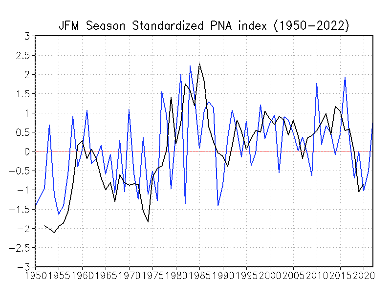
2000 through 2018 was dominated by a positive PNA pattern which created troughing in the east the majority of the time. Unfortunately this has flipped to predominantly negative since 2018, hence more east coast ridge. We will get back to a positive PNA multi year pattern at some point. Just have to be patient.
-
One last day of record warm temperatures before reality sets in. Getting the last of the yard work completed and tracking 3 systems, life is good.
-
Central PA Fall Discussions and Obs
canderson replied to ChescoWx's topic in Upstate New York/Pennsylvania
Texas basketball recently had an exact same situation. When Chris Beard got fired for hitting his girlfriend, Rodney Terry stepped in and took them to the elite 8. They immediately gave him a 3 year contract. The team was garbage under his direct command and he was fired in 2 years. Be careful. -
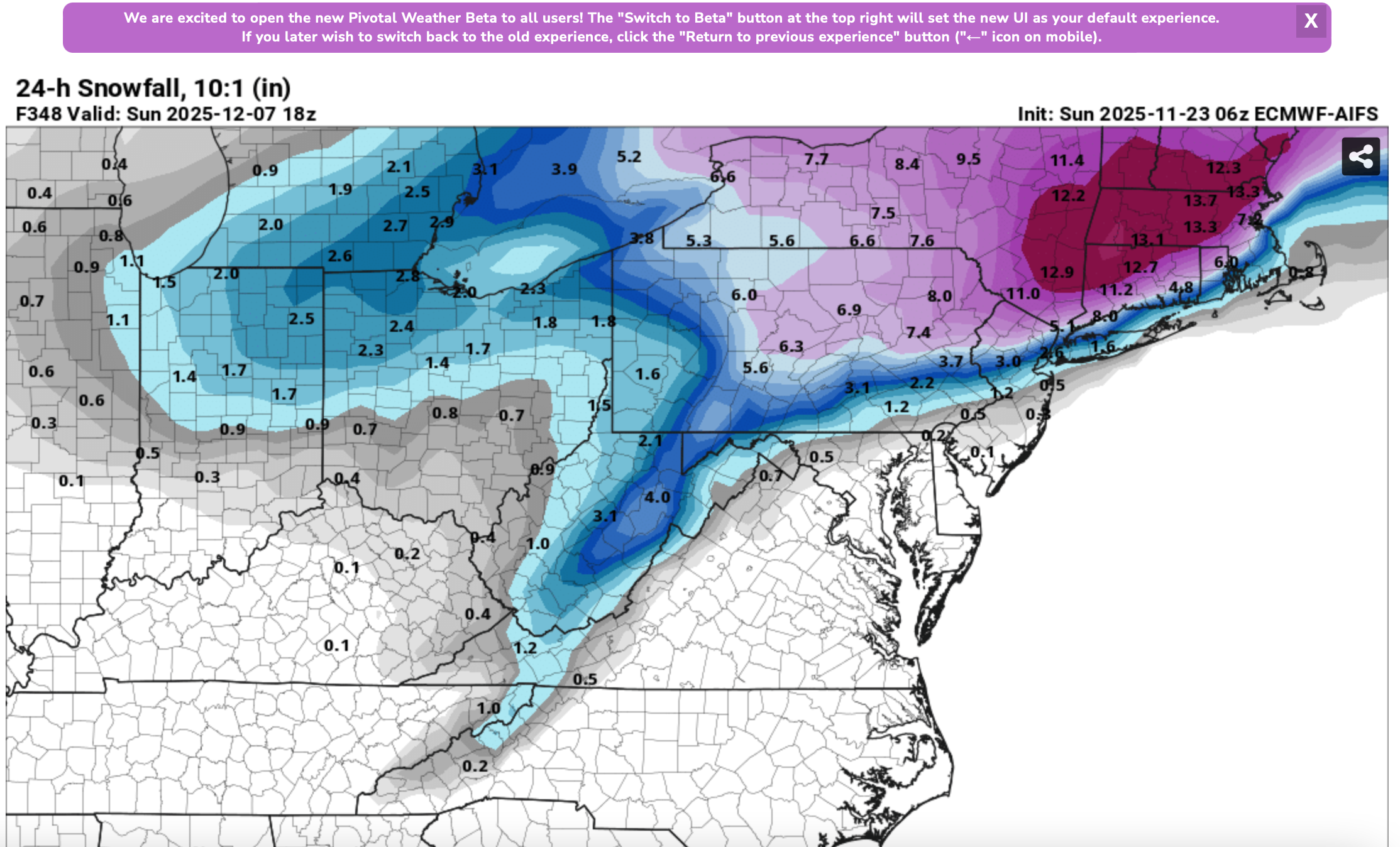
Just so everyone is aware... this is not AI Ensemble... just a single member. You'd be astounded if I posted the EC FRAM Freezing rain output from some of the recent EC cycles... ice storm big impact... fortunately ensembles temper enthusiasm and of course we're in the unreliable = beyond 10 day period when this occurs. I love EC AI but I've Zero experience monitoring beyond a week. Maybe we'll soon have occasion? I attached the most significant ECAI 24 hr 10 to 1 snowfall (not taking into account potential melting pavement). Note that most of this is in the last day or two of the 16 day cycle. I've no confidence. However, the ECAI seems a little colder than the traditional globals that we use and it has snow acc for I95 to the coast (including NYC/LI) around Dec 1-2. I need to see more support before it get enthusiastic.