All Activity
- Past hour
-

November 2025 general discussions and probable topic derailings ...
alex replied to Typhoon Tip's topic in New England
Started as sleet and freezing rain here. 25.7F. Let’s get to the other side of this BS so we can get back into an upslope flow -

November 2025 general discussions and probable topic derailings ...
512high replied to Typhoon Tip's topic in New England
36/ .14” has some sleet on the grill cover, lol baby steps…. -
Interesting development in the North Atlantic. SST'S becoming favorable for a -NAO this Winter. https://x.com/Aigle_e/status/1989420648234668098?s=20
-

November 2025 general discussions and probable topic derailings ...
dendrite replied to Typhoon Tip's topic in New England
31.7° FZRAPL -
Interesting SST development in the North Atlantic : https://x.com/Aigle_e/status/1989420648234668098?s=20 Another factor increasing - NAO Odds this Winter.
-
Mansfield summit depth record highest shows 30" on Monday and Tuesday, with 33" on Wednesday, 28" on Thursday, and 30" on Friday. All of those could be in jeopardy. A record breaking week of snow depths?
-
BWI: 17.8 DCA: 11.4 IAD: 19.5 RIC: 8.5 SBY: 7.5
-

November 2025 general discussions and probable topic derailings ...
wxeyeNH replied to Typhoon Tip's topic in New England
31.9F sleet -
 29 at Pit2.......might be a little wintry to start. Too bad I'm in PVD so no reports from me.
 -
Foliage all gone here. Was a crappy one here as well.. wasn't alot of Color.
-
Yeah, he's mainly referencing NC Southward. I think we get in on some of the early December Action west of NC and Spine of Apps.
-
First time hearing thunder in several months.
-

November 2025 general discussions and probable topic derailings ...
NoCORH4L replied to Typhoon Tip's topic in New England
35 and rain in 01473 -

Mountain West Discussion
mayjawintastawm replied to mayjawintastawm's topic in Central/Western States
actually good point. Classic La Nina half-a-winter. My seasonal total was 45.9" which is not too much less than my average of about 55". But it didn't really start till January. -
Mountain West Discussion
mayjawintastawm replied to mayjawintastawm's topic in Central/Western States
And in fact I'm flying out Tuesday and returning Friday morning... well... -
Yeah that was loud for a min or two. Wasnt expecting that.
-
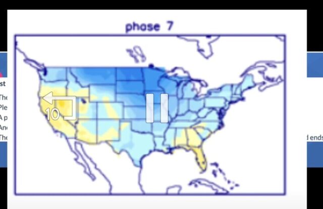
Phase 7 isnt bad either
-
I hope you’re right but the MJO actually reaching phase 8 is far from certain. Dec MJO in phase 8 has been difficult to come by for 15 years. The only notable (3+ days long) Dec phase 8 since 2009 was in 2017! 2023’s 8 zipped through in just one day. Some of this lack of Dec phase 8 was bad timing where they occurred late Nov or early Jan. But there were four times that phase 8 seemed to be blocked and instead it detoured and stayed back in 7 or went around to 1.
-
I laughed out loud at this.
-
To compare this most recent event to May 10th, 2024 is impossible as that one was in a class of its own and likely was once in a generation (strongest since 1989). Here are some of the shots I took in Orange County North Carolina outside of Hillsborough during that event.
-
Definitely another dry stretch... 0.01 monthly total...
-
I agree that a perfect pattern now would likely mean no snow outside the mountains but patterns repeat themselves and the one the next few weeks looks very Nina ish
- Today
-
I like Grit's posts. Good share. I tend to think we see a warmup in there, but recent LR ext modeling trends definitely support Grit. Interestingly, the analogs we looked at the other day maybe(off the top of my head without looking) seemed to support a mid to late cold outbreak.
-

2025-2026 ENSO
donsutherland1 replied to 40/70 Benchmark's topic in Weather Forecasting and Discussion
While I won't go overboard about December's prospects e.g., no 1983-type cold, an EPO-/WPO-/AO-/PNA- month wouldn't be the worst of outcomes. There should be opportunities for snowfall and at least some cold should periodically push into the East. I highly doubt we'll see a "torch" December.
-

November 2025 general discussions and probable topic derailings ...
powderfreak replied to Typhoon Tip's topic in New England
Sleet to start.


