All Activity
- Past hour
-
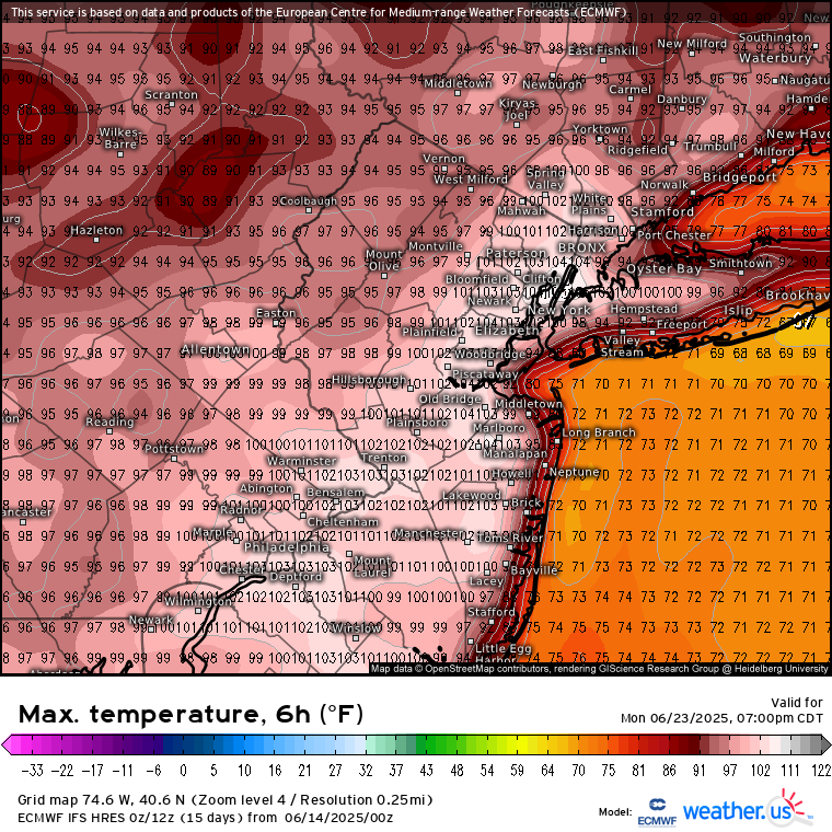
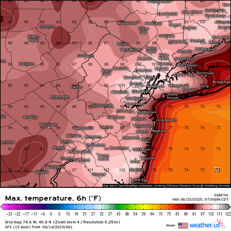
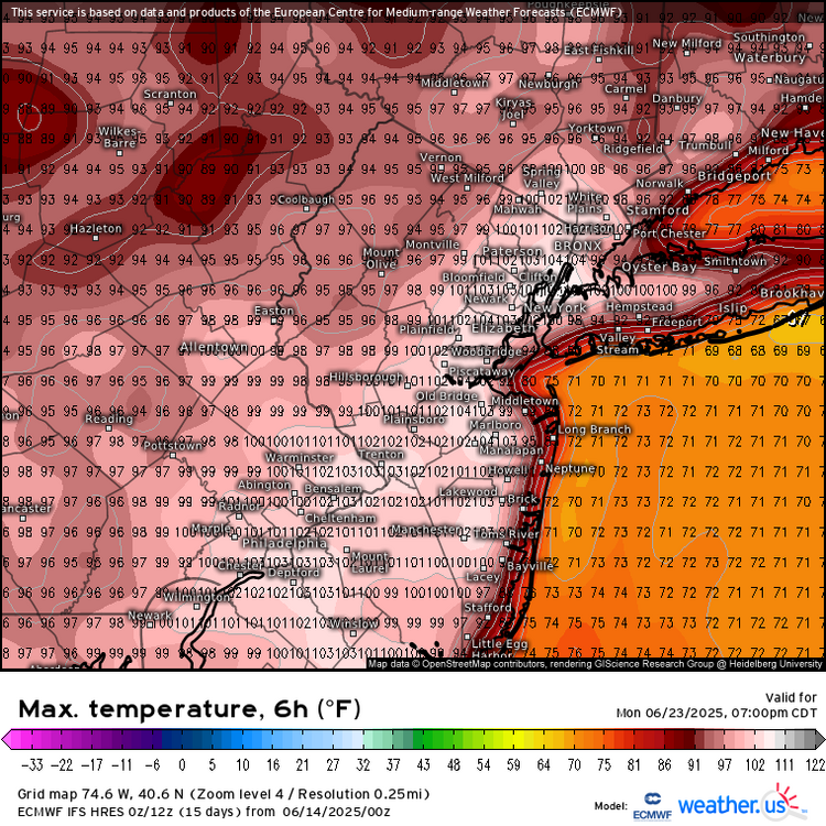
Then you are really going to enjoy the pattern in a little over a week. Both the Euro and GFS have westerly flow with 100° heat potential around the area. Even if the models are 7° too warm, the first 95°+ of the season looks like a good bet.
-
Wish it happens during October, this is garbage for June any way you slice it
-
How so? Forget about snow, December is colder than March. June is warmer than September.
-
Short-lived heat as we thought. They just can't win.
-
with our snowfall too, it seems like our first snowfall is around the winter solstice December 21 and our last snowfall is around the vernal equinox March 21.
-
Agree. Other places not so much, but in the tri state we match up better with astronomical seasons overall.
-
The only thing I remember about August 2011 was it being historically wet and getting that big earthquake. Before Irene we had training thunderstorms that dropped 10 inches of rain here on a Saturday, then we had that 5.8 earthquake and then Irene. August was much cooler than July, and it wasn't anywhere near as hot as 2010 was, which was our hottest summer on record, setting records for 90, 95 and 100 degree days here (thats how I judge heat, not by averages or mins.)
-
June 4, 2023 we had a low of 49, the first 40s low in June since 2000.
-
it's almost in the 50s here now omg Our seasons match the solstices much better -- June 21 to September 21 is hotter than June 1 to August 31
-
the seasons match astronomical seasons better, June 21 - September 21 is hotter than June 1 to August 31. It's almost in the 50s now....
-
it's almost in the 50s....
-
It's called having a mortgage payment and kids in school, highly effective anchors.
-
Crazy how much rain we continue to get here in middle TN. Looks like lower 90’s is showing up. I’m thankful we have held those temps off till the middle of June. Hopefully the moisture in the soil will keep high 90’s at bay. The trade off is higher humidity but I’d rather have that than dry & hot. Everything is so green still. My yard is thriving. For me so far the late spring/early summer has been fantastic. A+!
-

2025-2026 ENSO
Stormchaserchuck1 replied to 40/70 Benchmark's topic in Weather Forecasting and Discussion
I don't remember.. I'm sure it has happened, but I've noticed a big difference in these days between May and June. -
In the winter because the overrunning would be better this would likely be heavy 1-2”/hour snow. We only get these in the summer now on weekends.
-

2025-2026 ENSO
PhiEaglesfan712 replied to 40/70 Benchmark's topic in Weather Forecasting and Discussion
Yeah, 2011 was very historic heat. But even after the pattern turned wet, we still got very warm lows in August/September, which kept the temp departure above average. July 18, 2012 was the last 100 here at PHL. We got close in 2013 (the first 3 weeks of July were hot), but after that, it was unusually cool. I'm pretty sure it happened just 2 years ago. Remember the record low maxes during the summer solstice (June 21 and 22) in 2023? -
Thursday and Friday look like "Toland and Tiger Torched Tropical Taint" days if you enjoy that stuff. Highs mid to upper 80's and dewpoints may hit 70. Then back to more average temps and dewpoints for the weekend.
-
So close yet so far

-
Edibles
-
it's amazing how this winter hasn't yet really ended specifically for this discrete region of the planet. heh
-
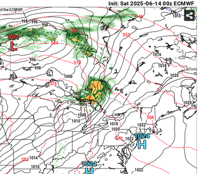
yup ... euro even manifests a nice mcs signal. only 180 hour out there but who's county. this appears to be on the nose of a 576 to 582 dm SW/W heat release in that run btw
-
It’s a shat day whether it’s 0.05” or 0.50”. BTV FTW today
-
2025-2026 ENSO
Stormchaserchuck1 replied to 40/70 Benchmark's topic in Weather Forecasting and Discussion
I might not get out of the 60s Sunday and Monday. June is usually a big seasonal transition. I can't remember a time after my birthday (early June) where that has happened before (not getting out of the 60s). -
The HREF looked pretty dry as well for several runs in a row. .10 to .20 for New England.
-
Area Forecast Discussion National Weather Service Baltimore MD/Washington DC 1011 AM EDT Sat Jun 14 2025 .SYNOPSIS... A stalled frontal boundary will continue to oscillate over the region through the weekend bringing increased chances for showers and thunderstorms. Thunderstorm activity will be tied to the afternoon and evening hours with flash flooding and locally damaging winds as the primary threats. The front lifts north as a warm front Tuesday into Wednesday with a strong cold front expected to cross late next week. Temperatures will remain at or above average through the period. && .NEAR TERM /THROUGH TONIGHT/... A stationary front is currently positioned over the northern DC metro. This boundary will become the focus for the development of heavy showers and thunderstorms late this afternoon and into this evening. Based on morning HiRes guidance, we have expanded the Flood Watch for flash flooding to the NE to include parts of the Baltimore metro along with parts of northern MD and eastern panhandle of WV. The environment this afternoon and into afternoon will be favorable for efficient rainfall with PW`s approaching 2 inches this afternoon and saturated through much atmospheric column. This environment will be favorable for hourly rain rates between 2 to 4 inches being possible with instantaneous rain rates approaching 6 inches per hour possible.