All Activity
- Past hour
-

February 22-23 Storm Thread/OBS
coastal front replied to Mikeymac5306's topic in Philadelphia Region
Yea I do recall hearing the same thing during that storm. Even the it over performed most modeling -
It’s always been that way tho. Gfs is the only one deepening the offshore low close enough to us to give us stupid totals. Without it, it’s rain/snow showers, with marginal temps and hoping the ivt sets up overhead. That ivt can easily be east or west and give central MD down to DC and VA next to nothing. but pretty snow maps
-
Even a blind squirrel is right twice a day
-
I've seen this movie before, my area gets stuck in subby between two bands and am halved the accumulating snow surrounding me, we'll see how it plays out, GFS looks good here, euro SE better, while we stat pad a few
-
Even if this whole thing manages to miss us somehow, can we all agree on the fact that calling threats, especially incredibly complex ones such as this, over is stupid?
-

“Cory’s in NYC! Let’s HECS!” Feb. 22-24 Disco
40/70 Benchmark replied to TheSnowman's topic in New England
Lets just not continue the wealth of bombing lows around Wallop island streak. -
“Cory’s in NYC! Let’s HECS!” Feb. 22-24 Disco
40/70 Benchmark replied to TheSnowman's topic in New England
I'm pretty much sold...though my largest fear is a Jan 2022 type of cut-off....that was one of the most demoralizing storms in memory for me and it cut deeply. -

Feb 22nd/23rd "There's no way..." Storm Thread
WxUSAF replied to Maestrobjwa's topic in Mid Atlantic
The IVT snow is after dark so that makes a difference. But I could still see urban areas, especially if they’re on the fringe of the heaviest snow, struggle with accumulation. Core of the IVT, especially away from the UHI probably will have 10-12:1 ratios. Edge of the IVT in urban areas could be like 5:1… -
Very unlikely Euro will be this wrong vs the GFS
-

“Cory’s in NYC! Let’s HECS!” Feb. 22-24 Disco
Sey-Mour Snow replied to TheSnowman's topic in New England
We can also put an end to the lack of bombing lows around the benchmark streak -
I’m taking the under on this one. It’s evolved from the 6” type scenario with good coastal transfer, and mostly a SWFE with weak players all around - surface high, primary, secondary are all weak… It’s also a much more progressive scenario — short duration. Ratios look 10:1 at best also. I’m going 3” here and calling it a day.
-
DT now acknowledging he has to change up his forecast just outside of the EURO now.
-
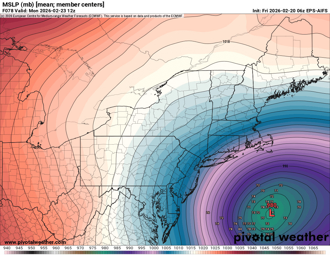
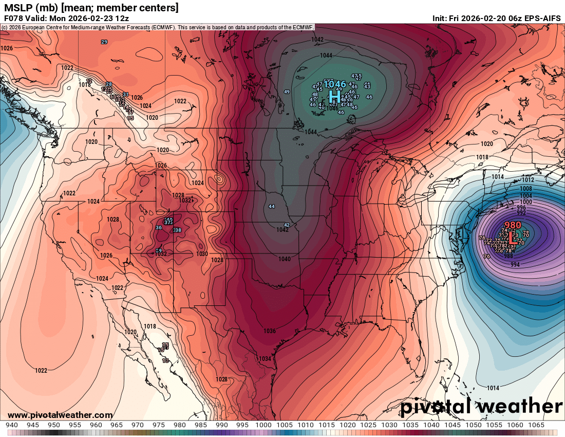
wow - all except one sub 980
-

“Cory’s in NYC! Let’s HECS!” Feb. 22-24 Disco
Baroclinic Zone replied to TheSnowman's topic in New England
Looks like 06z EPS will slay. -
“Cory’s in NYC! Let’s HECS!” Feb. 22-24 Disco
40/70 Benchmark replied to TheSnowman's topic in New England
Looks good from about me to @FXWX -

“Cory’s in NYC! Let’s HECS!” Feb. 22-24 Disco
The 4 Seasons replied to TheSnowman's topic in New England
One thing i can say for sure is we are miles better than where we were 24 hours ago. And that's a win. Could have been just as uncertain or a main model trend towards where the Euro was 24hr ago and that didn't happen. -
Probably wise. The GFS will either score the biggest coup of the last 10 years or cement its legacy as the GOOFUS.
-

Feb 22nd/23rd "There's no way..." Storm Thread
snowfan replied to Maestrobjwa's topic in Mid Atlantic
Daytime non accumulating snow. The heartbreak meter on this one is high even if the potential high reward exists -
Euro aifs are west with more members west as well

-
Feb 22nd/23rd "There's no way..." Storm Thread
dsnowman replied to Maestrobjwa's topic in Mid Atlantic
I don’t think there is a middle ground here with temps. We either get the earlier phasing / coastal development where rates overcome temps (GFS / NAM) and we get pummeled, or we get a few inches of wet snow (EURO, UKMET). Where have I seen this movie before. . -
AI EPS getting closer...

-
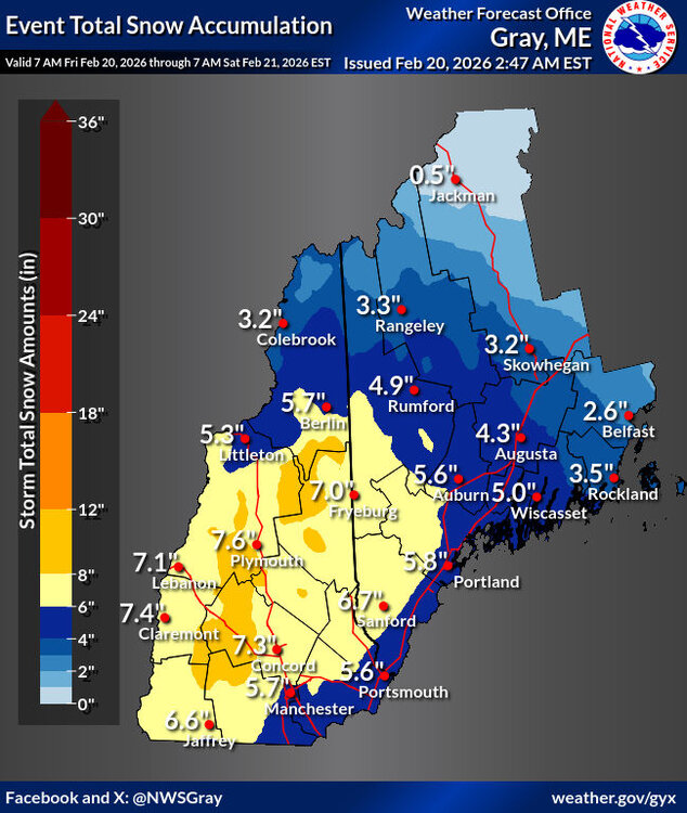
.55” so far.
-
We will have tonight if we can't get Monday far enough to the west, Still like 3-5".
-
Without the bombing coastal, the gfs would be low impact too
-
This is the way. Not worth it to make life more difficult. But maybe it will snow just enough to let Diet Coke dollar bill George be wrong