All Activity
- Past hour
-

December 2025 Short/Medium Range Forecast Thread
Carvers Gap replied to John1122's topic in Tennessee Valley
I really think it has been a while since we have had a cold source like this. Models/people are trying to adjust. -

Central PA Winter 25/26 Discussion and Obs
pasnownut replied to MAG5035's topic in Upstate New York/Pennsylvania
as long as it no prolong torch that asshat Tim B was touting, I think were fine w/ the back n forth until winter reloads and Jan is rockin (thats purely wishcast with 0 modelology injected). -

Southern MD / Lower Eastern Shore weather discussion
SnowtoRain replied to PrinceFrederickWx's topic in Mid Atlantic
Still 0 to 2" across most of Delmarva, @CAPE has the best chance of 2 to 3". Millington to Galena probably best chance of 4" -
Think might have the view from Planet X somewhere
-

12/14: Sunday funday? Will the south win again?
MN Transplant replied to TSSN+'s topic in Mid Atlantic
5pm Sunday wind chills of -5 to +5. Get your stuff done today. -

Saturday night/Sunday 12/13-12/14 Jawn
anthonyweather replied to Ralph Wiggum's topic in Philadelphia Region
Hrrr and rap are gonna give yall jawns a heart attack . -

12/14: Sunday funday? Will the south win again?
Scarlet Pimpernel replied to TSSN+'s topic in Mid Atlantic
Can you zoom that out to the global scale, please?? -

December 14th - Snow showers or Plowable snow?
moneypitmike replied to Sey-Mour Snow's topic in New England
Was he wearing a Cowboy's jersey? -

Central PA Winter 25/26 Discussion and Obs
Blizzard of 93 replied to MAG5035's topic in Upstate New York/Pennsylvania
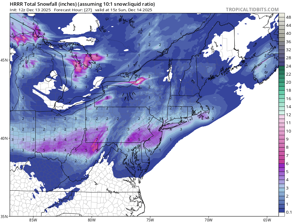
12z National Blend of Models has its best look yet especially back towards the Harrisburg area with almost 3 inches back there now.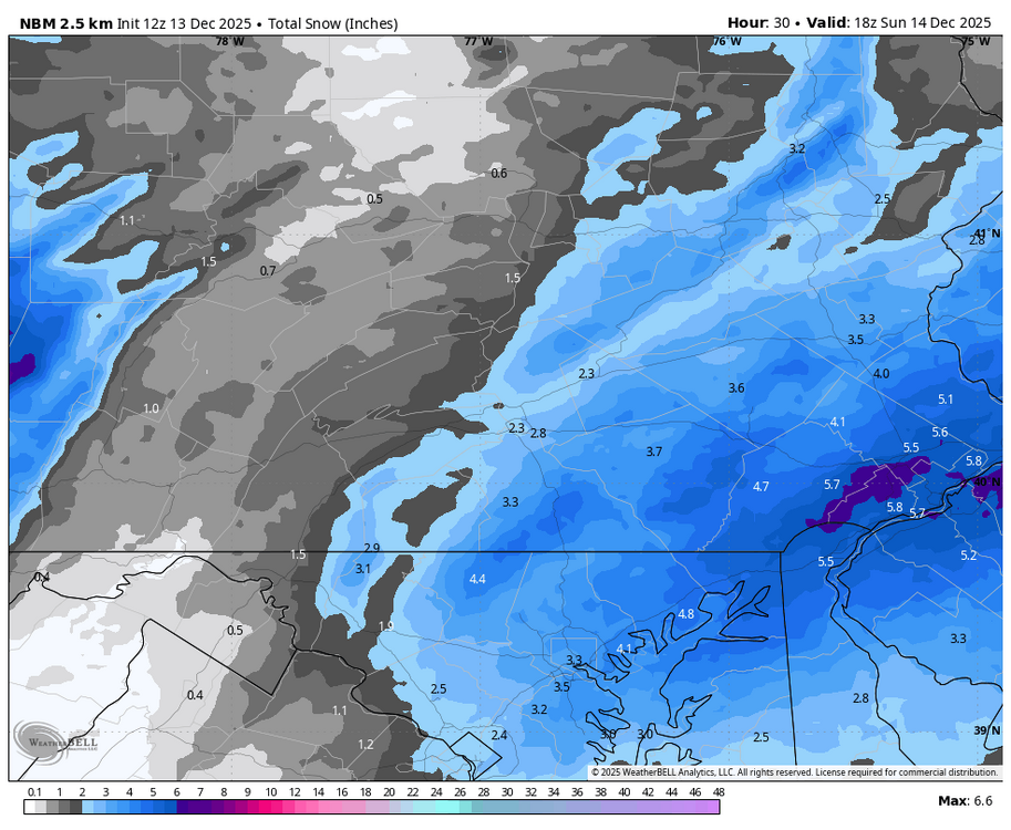
-

Minor snowfall sunday 12/14/25 1-4” possible
MJO812 replied to WeatherGeek2025's topic in New York City Metro
Yep keeps getting stronger. -

Minor snowfall sunday 12/14/25 1-4” possible
weathermedic replied to WeatherGeek2025's topic in New York City Metro
OKX AM AFD: SHORT TERM /6 PM THIS EVENING THROUGH MONDAY NIGHT/... Key Points: * 1 to 4 inches of snow are expected across the area tonight into Sunday morning, with up to 5 inches in eastern Long Island. * Winter Weather Advisories have been expanded slightly west and north to include all coastal zones from 10pm tonight through 1pm Sunday. * Windy and cold Sunday night into Monday morning with wind chills below zero in some areas. A strong closed h5 low dives SE through the Great lakes tonight. Associated positively tilted trough helps send a cold front through the area tonight. An area of low pressure forms along the front to our south in response. Because of the positive tilt, the low will be progressive and not really strengthen more rapidly until it is well off to our east. The precip shield with this system is however still expected well north of the weak low center and into our area thanks to synoptic lift courtesy of the right-entrance region of a strong upper jet streak adding to shortwave lift and the cold front itself. NBM and WPC liquid equivalent precip are in line with consensus of deterministic and ensemble model output. While there appears to be only modest omega in the dendritic snow growth zone, the zone is large due the magnitude of the cold aloft and is saturated. Upward motion is still there with the upper divergence and PVA. This, along with much of snowfall occurring at night and cold/low wet-bulb zeroes, should help offset the more typical lower liquid to snow ratios one would expect with surface temperatures close to freezing, which will be the case for the coastal areas for much of the event. Generally speaking, precip type starts as rain or a rain/snow mix at the coast with mainly snow inland this evening before a changeover to snow everywhere by midnight. Greatest impacts will be from late evening through at least mid-morning Sunday when the snow will have an easier time sticking to untreated surfaces. Snow should be exiting east out of area by around noontime Sunday. Snow amounts have not changed much from the previous forecasts, but with more confidence in the totals, Winter Weather Advisories for tonight into Sunday have expanded to include coastal CT, Southern Westchester County, and additional parts of NE NJ. Winds then pick up Sunday night into Monday and will be gusty with strong cold advection and a tightening pressure gradient. Wind chills late at night into Monday morning dip to -5 to 10 above, but are short of Cold Weather Advisory criteria. Highs on Monday will be averaging only around 30 - well below normal. Winds then diminish Monday night with wind chills not as cold this time, but still in the single digits to teens. -
Over 1/2” qpf here… gimme
-

December 14th - Snow showers or Plowable snow?
CoastalWx replied to Sey-Mour Snow's topic in New England
I’d feel better for another tick. -
Central PA Winter 25/26 Discussion and Obs
Blizzard of 93 replied to MAG5035's topic in Upstate New York/Pennsylvania
You have 20:1. Chris posted Kuchera which will factor in the helpful ratios in this scenario. -

Pittsburgh/Western PA WINTER ‘25/‘26
TimB replied to Burghblizz's topic in Upstate New York/Pennsylvania
NWS has nudged totals up in Allegheny county with the latest update and added the “heavy at times” wording. Maybe laying the groundwork for a warning? -

December 14th - Snow showers or Plowable snow?
WinterWolf replied to Sey-Mour Snow's topic in New England
He’s pretty close to the coast too there though. -
Well, I sure hope that's the case. The long post I put above the one with the "Lord, it's a miracle!" gif was just some stuff I observed from cursory looks at the 500-mb flow. I'd much prefer (and assume others as well) a broad bowl than a pumped up ridge that not only would torch us but would blow away cold air in Canada which would take a longer time to regenerate. BTW...you don't care for "Shawshank Redemption" (the gif I put up there), with the weenie tag emoji??
-
December 14th - Snow showers or Plowable snow?
CoastalWx replied to Sey-Mour Snow's topic in New England
Oh I am close to the water. Sometimes people think I live near Plymouth lol. -
-

December 14th - Snow showers or Plowable snow?
UnitedWx replied to Sey-Mour Snow's topic in New England
Ah ok. For some reason all this time I thought you were closer to the coast. Im right near RT20 on the west side of Westfield. -

December 14th - Snow showers or Plowable snow?
TauntonBlizzard2013 replied to Sey-Mour Snow's topic in New England
To be fair, there is a more northerly component once you get into eastern. You certainly couldn’t better than someone of the same latitude in say CT -
December 14th - Snow showers or Plowable snow?
WinterWolf replied to Sey-Mour Snow's topic in New England
It thought about it..my girl wants to come home though, so we coming home. We should be home before the snow starts, if not the truck is good in it. -
Thanks! We have reservations at 6:30. Should be home well before midnight.
-

December 14th - Snow showers or Plowable snow?
Baroclinic Zone replied to Sey-Mour Snow's topic in New England
That models been flaccid. Bout time it took a dose of cialis. -

Minor snowfall sunday 12/14/25 1-4” possible
Mr. T. replied to WeatherGeek2025's topic in New York City Metro
HRRR is way amped. Looking even better now.