All Activity
- Past hour
-
It’s the scale
-

Hurricane Erin - 100 MPH - 971 MB - WNW @ 17
Windspeed replied to BarryStantonGBP's topic in Tropical Headquarters
He meant at the 925 mb flight level. Not at the surface. At any rate, faster than steady intensification continues, but the lid is about to come off. Expect rapid deepening through Saturday and high-end Category 4 type intensity until outer banding consolidates. Given the regional environment and outflow pattern, Erin most likely will grow into a large size hurricane by Tuesday. So expect several replacement cycles with periods of reintensification in-between. - Today
-

Hurricane Erin - 100 MPH - 971 MB - WNW @ 17
TriPol replied to BarryStantonGBP's topic in Tropical Headquarters
9...25??? Is that right? -
If it’s anything like the first half of last fall, I’m all for it. The winters just aren’t what they used to be around here (at least on the coastal plain) and by mid January, I’m usually thinking of much brighter skies and greener pastures! We really gotta do away with the whole daylight savings bs imo..that would really take a huge sting off of things.
-
^^ My windshield gets pretty well plastered going up the Taconic too.
-

Hurricane Erin - 100 MPH - 971 MB - WNW @ 17
WxWatcher007 replied to BarryStantonGBP's topic in Tropical Headquarters
I don't believe so. It looks like Erin's core isn't being hindered at all by it. Dropsonde in the NW eyewall measured 89kt at the surface and 99kt just off the deck at 925mb. -

Hurricane Erin - 100 MPH - 971 MB - WNW @ 17
GaWx replied to BarryStantonGBP's topic in Tropical Headquarters
Is there any significance to the 2nd area of deep convection to the SW of the main area? -
Hurricane Erin - 100 MPH - 971 MB - WNW @ 17
WxWatcher007 replied to BarryStantonGBP's topic in Tropical Headquarters
As @Boston Bulldogsaid, Erin is taking off. After struggling with SAL and drier air, Erin looks to have mixed that out and organized substantially, with a closed eyewall for hours now per recon, much better vertical alignment, and a tightening RMW. In the image below, note how the first pass had a weaker sampling of winds in the southern half of the storm, but subsequent passes now show a more symmetrical distribution of strongest winds in the eyewall. As the NHC notes, the environment is conducive for explosive intensification. Wind shear is low for now, the outflow continues to become more impressive, and moisture looks like much less of an issue. The islands, even though there are likely to be some impacts, are incredibly fortunate that they are not in the direct path of what is going to become a buzzsaw in the next 24-36 hours. -
0Z UK is similar to the 12Z with a TS N of the Leewards moving WNW:NEW TROPICAL CYCLONE FORECAST TO DEVELOP AFTER 132 HOURSFORECAST POSITION AT T+132 : 15.6N 56.6WLEAD CENTRAL MAXIMUM WINDVERIFYING TIME TIME POSITION PRESSURE (MB) SPEED (KNOTS)-------------- ---- -------- ------------- -------------1200UTC 21.08.2025 132 15.6N 56.6W 1009 260000UTC 22.08.2025 144 16.3N 58.8W 1007 321200UTC 22.08.2025 156 18.1N 60.9W 1006 370000UTC 23.08.2025 168 19.4N 63.3W 1005 38
-

Hurricane Erin - 100 MPH - 971 MB - WNW @ 17
Boston Bulldog replied to BarryStantonGBP's topic in Tropical Headquarters
Erin is about to put on a show.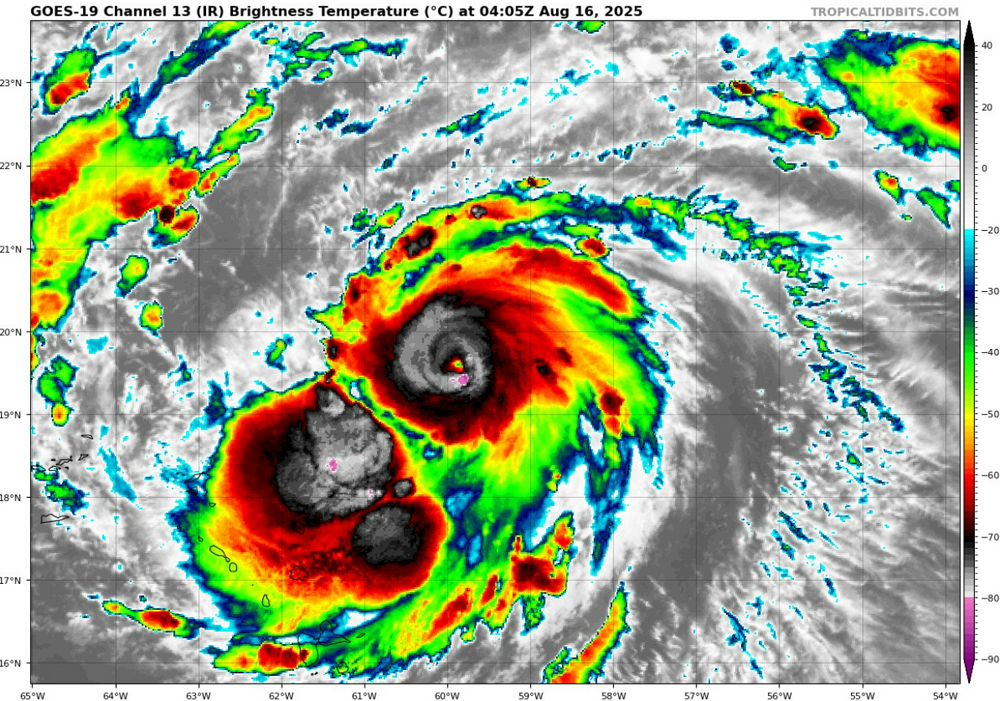
-

Hurricane Erin - 100 MPH - 971 MB - WNW @ 17
Diggiebot replied to BarryStantonGBP's topic in Tropical Headquarters
Consolation this will be a great hurricane to watch -
Fall can be nice until about December 1
-
Days and days of above average temps mixed with rain, mist and fog until mid April? I can’t friggin wait man.
-

Hurricane Erin - 100 MPH - 971 MB - WNW @ 17
hawkeye_wx replied to BarryStantonGBP's topic in Tropical Headquarters
Down to 975 mb. -

E PA/NJ/DE Summer 2025 Obs/Discussion
KamuSnow replied to Hurricane Agnes's topic in Philadelphia Region
Had a little light shower here, right before 7pm. Barely wet the driveway, but saw a rainbow off to the east:(1).thumb.jpg.10cfcff983b4c84ddfd168a35c23c7c0.jpg)
-
Dude wow that's beautiful
-
 Going to guess at this; JFK is probably <1 mile from Jamaica Bay and beyond that obviously has a longer fetch seabreeze off of the larger and much deeper Atlantic Ocean. HVN is further from the coast and can have a fetch of ~20 miles, Long Island Sound is not as deep. I believe in the area of 65 feet for the central area. Maybe the Sound Breeze takes longer to develop and thus HVN can have a higher maxima before the onset. Other than that, I got nuttin'.
 -

Hurricane Erin - 100 MPH - 971 MB - WNW @ 17
LongBeachSurfFreak replied to BarryStantonGBP's topic in Tropical Headquarters
Outflow is textbook. If it weren’t for some dry air intrusion we could see some insane RI. Even still heading towards 29/30c water temps should allow a shot at 135kt. -
Picked up 0.07". Now a little more than an inch for Aug.
-
And also...how about Brandon Frickin' Young with 7.2 perfect innings??? (Darn you Urias--I KNEW that was gonna haopen just as a poke in the eye to Elias who should've kept him, lol). Baseball is a funny game! That was really something! What a way to get your first big league win, lol
-
Yeah I have concerns about Elias still being here when the new manager is selected--and don't trust him in letting the manager hire his own staff. Everybody but maybe Britton and the other guy (I think his name is Mayer?) has got to go. And you know...Drew French is not a terrible pitching coach either, imo
-
https://photos.fife.usercontent.google.com/pw/AP1GczNUEQdR2-TxQvjMZ6dEjDGAc6lMAaYlzeTU7d6q-NhI2wHuRUrjlbn3pQ=w985-h739-s-no-gm?authuser=0 Picture I took just before the storm hit. Saw a few gusts over 70 mph.
-

Hurricane Erin - 100 MPH - 971 MB - WNW @ 17
Eskimo Joe replied to BarryStantonGBP's topic in Tropical Headquarters
-
Hurricane Erin - 100 MPH - 971 MB - WNW @ 17
Eskimo Joe replied to BarryStantonGBP's topic in Tropical Headquarters
Didn't Matthew in (2016?) have that dual blob and it wasn't a big deal against intensification either> -
Hurricane Erin - 100 MPH - 971 MB - WNW @ 17
Boston Bulldog replied to BarryStantonGBP's topic in Tropical Headquarters
I don’t think the dual blob structure is going to preclude Erin’s RI. The southerly mass of thunderstorms should either dissipate or form into a curved band. Even if it doesn’t, we’ve seen powerful hurricanes with a second convective mass such as Matthew. Honestly Matthew was a fascinating storm, I’m sure there are great papers discussing its structure. Not sure what caused it Very impressed with Erin’s gigantic ventilation right now, the anticyclonic outflow is sprawling across all quadrants


(1).jpg.3721762a4a1f2e7c81da6a66aafda0e1.jpg)


