All Activity
- Past hour
-

The “I bring the mojo” Jan 30-Feb 1 potential winter storm
bigjohndc replied to lilj4425's topic in Southeastern States
We got a surprise inch and half last night, which no model picked up even as it was happening. If you look at the 12z HRRR it’s initializing way to dry. Compare the actual radar to the model. Maybe I’m a weenie, but until the coastal really gets going we don’t know how long the dry slot will stick around. Especially as everything pivots and moves west to east. 2-5 through the triangle isn’t out of the question. We only need to get like .2 inches of liquid to achieve that. -

Jan 30th-February 1st 2026 Arctic Blast/ULL Snow OBS Thread.
John1122 replied to John1122's topic in Tennessee Valley
Moderate snow, vis around 1/2 mile. 6.5 to 7 inches. It's gotten hard to measure due to wind. -

The “I bring the mojo” Jan 30-Feb 1 potential winter storm
SHTFWX replied to lilj4425's topic in Southeastern States
Looks like the dry slot is settling in nicely over the Triangle area right now. Personally, I have slowly lost quite a bit of respect for Brad P over these last few years. Not so much for his Met work, but for the obvious gaslighting and narcissism -
And doesn’t keep us shutdown for days. My outlook has changed since being WFH and having a toddler that goes to school (but doesn’t during snow). .
-

The “I bring the mojo” Jan 30-Feb 1 potential winter storm
SnowHabit replied to lilj4425's topic in Southeastern States
Very light and scattered flurries have started falling here on Fort Bragg, NC. -

Jan 30th-February 1st 2026 Arctic Blast/ULL Snow OBS Thread.
BlunderStorm replied to John1122's topic in Tennessee Valley
It's been satisfying to watch the swva dry slot fill in. I was ready for it fizzle down. Visibility is back down to a half mile. The shift seemed to start as the axis of precipitation changed from west to southwest. On the meso it appears as spotted cold tops but the gaps are filled. Could the tilt of the ULL or increased proximity be the cause? Should be locked in for at least another hour of decent rates. Maybe more. -

Arctic Hounds Unleashed: Long Duration Late January Cold Snap
ORH_wxman replied to WxWatcher007's topic in New England
-16 at OWD. Lol. What a swamp there. -

January 30th- Feb 1st ULL and coastal storm obs
WinstonSalemArlington replied to JoshM's topic in Southeastern States
Winston-Salem -
The last thing I would have expected was possibly getting a foot of snow today. It's not out of the question. Unreal!
-

January 30th- Feb 1st ULL and coastal storm obs
ncstatered21 replied to JoshM's topic in Southeastern States
Dang. If they actually play the NC State vs. Wake Forest basketball game. Think NC State might be hanging out in Winston for a day or 2. . -
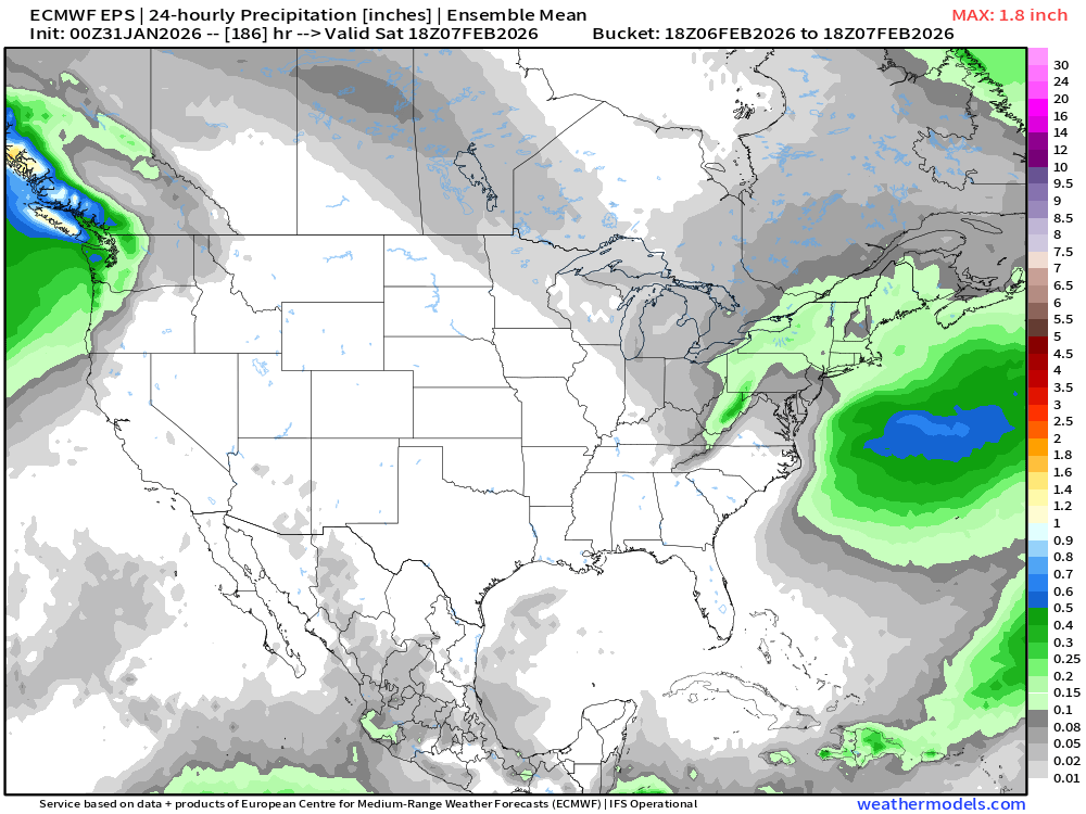
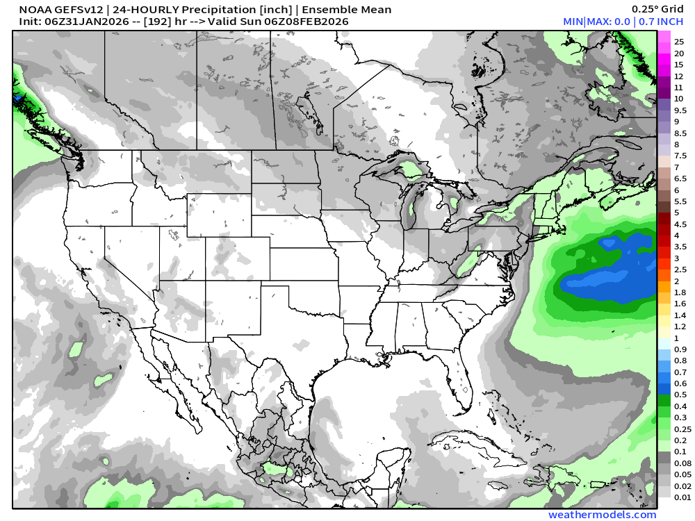
There’s some moderate interest in the ensembles redeveloping the clipper next weekend into a miller B.
-
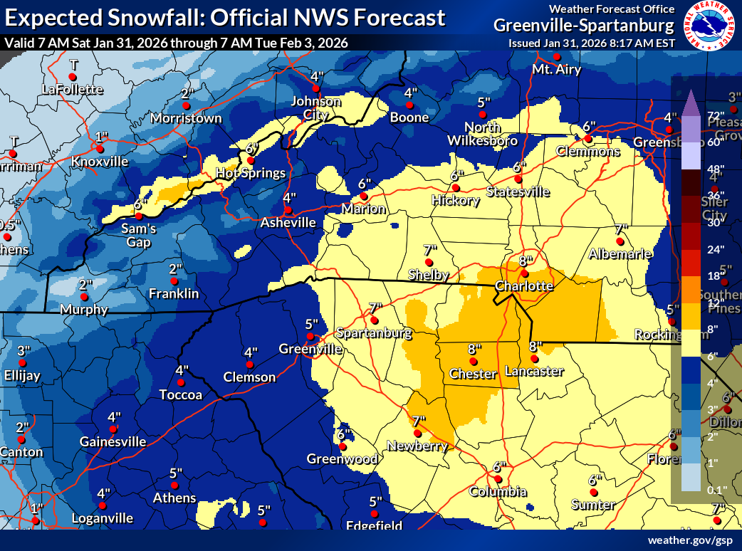
Just released about ten minutes ago. So, this is on top of what has already fallen:

-

Richmond Metro/Hampton Roads Area Discussion
jlewis1111 replied to RIC Airport's topic in Mid Atlantic
weekend crew is horrible -

The “I bring the mojo” Jan 30-Feb 1 potential winter storm
Silver Meteor replied to lilj4425's topic in Southeastern States
"Coastal Low" is awfully damned far away from the coast. Move that sumbich a hundred miles due west and the Eastern Carolinas would have one heck of a storm. Forecast snow totals in the east have already fallen. With all this Arctic air the coast had a lot more potential. https://www.ventusky.com/wind-speed-map/10m-above-ground#p=33.81;-76.82;6&w=0xIAb9A9A -

February 2026 Medium/ Long Range Discussion: Buckle Up!
CAPE replied to Weather Will's topic in Mid Atlantic
You should be keeping an eye on the 11-12th window you claimed- on the ens runs. Stop looking at the ops. I told you I would expand that window a bit.. the trough out west might work for us with the favorable NA look towards mid month. -
It doesn’t start to get hostile for snow here until 2/21. “Prime” snow season for our area is 12/20 - 2/20
-
Richmond Metro/Hampton Roads Area Discussion
jlewis1111 replied to RIC Airport's topic in Mid Atlantic
Oh I guess you believe in global warming too lmao -
The “I bring the mojo” Jan 30-Feb 1 potential winter storm
Aleksey replied to lilj4425's topic in Southeastern States
Snow has just begun here in Winder, GA . -

Let’s talk winter!! Ohio and surrounding states!! 24'-25'
iluvsnow replied to buckeye's topic in Lakes/Ohio Valley
Saw a -25 on a Wundermap observation location just NE of Columbus just after 8 this AM. Many locations in the minus teens. Perfect radiational cooling. I wonder if the overnight lowest temps in the lower 48 might be in Ohio. A rare feat if it happens. -
January 30th- Feb 1st ULL and coastal storm obs
WinstonSalemArlington replied to JoshM's topic in Southeastern States
Jeff Crum checks in from center city Charlotte https://x.com/wxcrum/status/2017588784854978591?s=46&t=5ny5bPgiX5Vy3bQMvYTY5g -
The “I bring the mojo” Jan 30-Feb 1 potential winter storm
ncstatered21 replied to lilj4425's topic in Southeastern States
Yeah I see some mPings like 10 minutes east of Holly Springs. Radar also looks to be filling in down south around Laurinburg -
But they will complain about 2-3 inches because they saw a foot. Its ridiculous actually. 2-3 inches is very nice. Just enjoy it.
-

February 2026 Medium/ Long Range Discussion: Buckle Up!
Climate175 replied to Weather Will's topic in Mid Atlantic
Yup. -
Yeah, I was going off @WXNewton's post for my start time. He's essentially 20 minutes to my south and east.
-
Seems physically impossible to have a low temp other than 7 or 8 this week.