All Activity
- Past hour
-
Although Dr. No has been masquerading around as Dr. Yes on this storm so far.
-

Possible Record Breaking Cold + Snow Sunday 1/25 - Tuesday 1/27
Snowguy66 replied to TriPol's topic in New York City Metro
What I really meant was that model forecasted long duration events most of the time don't come to fruition. I see them all the time advertise in models and yes, some do happen but most of the time it's not as long as the model is showing. I love long, duration events. Outside of total snowfall that is my second desire out of a snowstorm. If we get a 24+ our snowstorm out of this one will be super ecstatic. -

Possible Record Breaking Cold + Snow Sunday 1/25 - Tuesday 1/27
eduggs replied to TriPol's topic in New York City Metro
With that prolonged easterly fetch some of the spots in SENJ and EMA that are favored for ocean enhancement could approach 2" liquid - a lot of which could be frozen. Great to see both the ICON and UK well over 1" liquid across most of our area. -

Richmond Metro/Hampton Roads Area Discussion
chris624wx replied to RIC Airport's topic in Mid Atlantic
The next threat looks interesting, at least. Don't know if i have it in me for another heartbreak though haha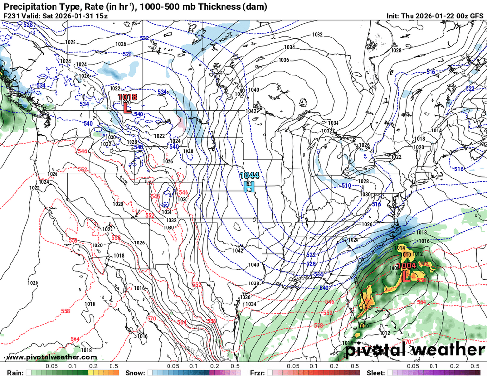
-
For the cold outbreak following the storm, at least on the GFS I've noticed a consistent pattern where the VA and even NC piedmont gets sub-zero lows and we're stuck in the single digits. This isn't elevation dependent since it's placing them in low elevation areas to the south and snowpack is high everywhere. Instead it looks like it's because of low-level winds that are calm down south but present at 925mb above Maryland. I've seen this same thing in forecasts after snow events last year and I still can't understand the dynamical reason for it. Is Emporia VA and thereabouts really a better place for vodka cold following a storm pass than MD?
-

“Cory’s in LA! Let’s MECS!” Jan. 24-26 Disco
40/70 Benchmark replied to TheSnowman's topic in New England
So where do you think this is going? Over ORH? -
Paging Dr. No
-
I’m praying Winston Salem gets spared the ZR. The QPF has been consistently 1.5+. The trends are heading that way though. Best I can hope for is IP
-
Oh my goodness. Hmm!
-
Incredible to watch that thread on the southeast forum. 30 pages in like 24 hours, I think they're all going insane
-

January 25/26 Jimbo Back Surgery Storm
Silver Meteor replied to Jimbo!'s topic in Southeastern States
Thanks for the insight. -

Possible Record Breaking Cold + Snow Sunday 1/25 - Tuesday 1/27
brooklynwx99 replied to TriPol's topic in New York City Metro
CMC looks like a clear amped outlier so far at 00z... even then, it's still 6-8" for the metro with some mix at the end, which shows how good this setup is -
 UKMET At least 90% of it is snow for NYC Metro, would be a huge hit.
 -

Possible Record Breaking Cold + Snow Sunday 1/25 - Tuesday 1/27
SACRUS replied to TriPol's topic in New York City Metro
Updated -
UKMET is kind of strange in that it really blasts that primary into WV/PA but it doesn’t torch the mid levels as fast as the Canadian which does the same thing at the surface.
-
1.25" 24.8
-
Ukie looks like it saves Upstate SC and parts of WNC, but the CAD is still really strong. It looks like its going to be pretty tough to scour out this LL cold air unless the storm Amps even further than we have seen in trends as of late.
-

January 25/26 Jimbo Back Surgery Storm
Blacksburg Coach replied to Jimbo!'s topic in Southeastern States
-

Pittsburgh/Western PA WINTER ‘25/‘26
Rd9108 replied to Burghblizz's topic in Upstate New York/Pennsylvania
Oh no the Ukie shows 14 inches damn.... This is what im hoping happens -Pirates sign Suarez -We get 18 inches of snow -followed by the Steelers hiring Shula. -

Possible Record Breaking Cold + Snow Sunday 1/25 - Tuesday 1/27
NorthShoreWx replied to TriPol's topic in New York City Metro
Then you would have loved the blizzard this week in 1978: https://www.northshorewx.com/19780120.html -
At 33.5 at WXW1, but the radar looks great. Snowing nicely on camera.
-

Pittsburgh/Western PA WINTER ‘25/‘26
PghPirates27 replied to Burghblizz's topic in Upstate New York/Pennsylvania
Yep even if we mix if we get 8” before that I’m in. Crosby keeps rolling. -
Possible Record Breaking Cold + Snow Sunday 1/25 - Tuesday 1/27
SACRUS replied to TriPol's topic in New York City Metro
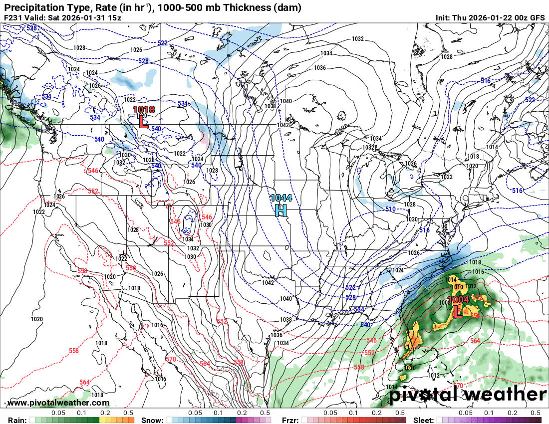
UMET 1/22 00Z Total QPF - storm -
Possible Record Breaking Cold + Snow Sunday 1/25 - Tuesday 1/27
eduggs replied to TriPol's topic in New York City Metro
The UKIE is ICON-esque! Maybe a tick warmer than the ICON but better than 12z IMO. Threatens a mix/dryslot or at least lull, but redevelops on Monday! Sweet run! -

“Cory’s in LA! Let’s MECS!” Jan. 24-26 Disco
Ginx snewx replied to TheSnowman's topic in New England
Some serious good bud being smoked in here.


.thumb.jpg.ad3a2e31d30aff035044689b311a0540.jpg)


