All Activity
- Past hour
-
Can the Orioles sweep the A’s today? This is the period we have to take advantage of. We are 1GB of the Wild Card and we have this game today, and 3 vs Col. You sweep at least one and win the series in another and you’re over .500 staring at the final WC spot before a pivotal 7 game stretch incoming at home. Time will tell, but I’m keeping expectations low. As for the Ravens, I was at the game and truly enjoyed what I saw. This defensive scheme is looks pretty sharp, but Minter said this is actually relatively vanilla. The staff has been calling specific plays for specific players to see who they fare so they can analyze further to see who they want to keep. The more exotic play scripts are under wraps for now. Offense has some solid depth pieces, so it’ll likely come down to health and Oline play this season. Kicker concerns me, but that’s something that can be replaced in short order, so I’m not too worried….yet. I hope Loop can write the ship.
-
I’m throwing the rest of my tomato garden at whoever wants this smoke I’m ready for fall, but Mother Nature has other ideas. Ridge center will thankfully not be overhead, so it could’ve been worse. Heat Advisories are probably likely this week in many spots.
-
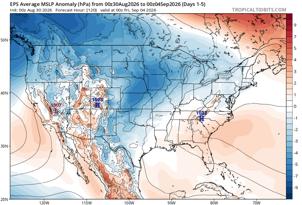
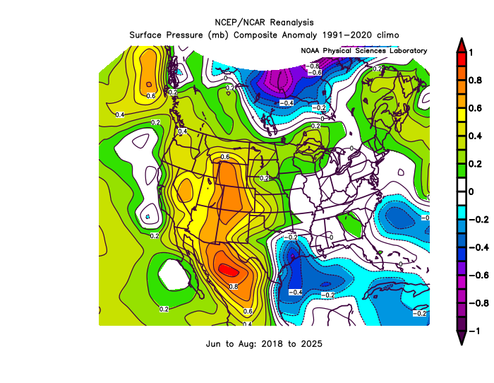
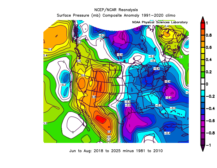
The stuck fronts are a function of the increasing summer high pressure over Eastern Canada building down to east of New England at times. This also enhances the dew points with more onshore flow. Also leads to multiple flash flooding events across the area. We used to get more high pressure to our west with offshore flow prior to this decade. Those were the years you highlighted with more 90° days at JFK. These days the higher 90° counts are west of the sea breeze front in NJ.
-

Monday, August 31 - Wednesday, September 2, 2026 Convective Episodes
weatherwiz replied to weatherwiz's topic in New England
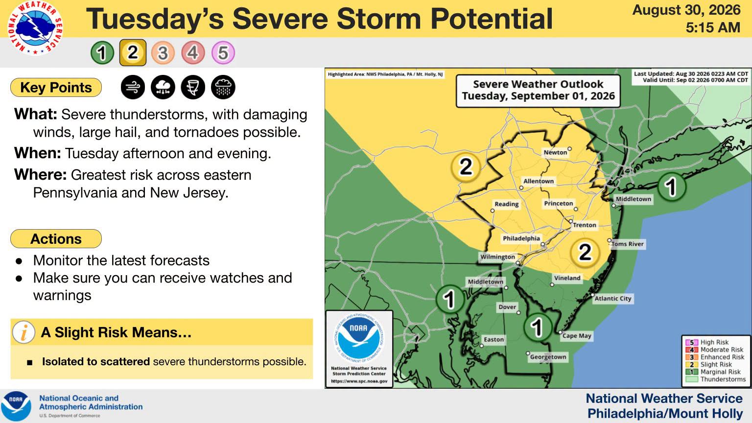
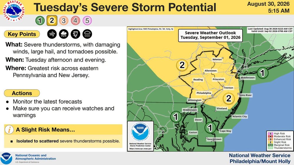
Lutchfield/Fairfield County definitely in the game for Tuesday on the 12z NAM. Right along the warm front and instability gradient and also perfectly positioned where shear/instability are maximized. This is going to be a really fun nowcasting situation -
Picked up 0.09" this morning. 0.50"+ missed just to the north/northeast.
-
 buying generic clomid without prescription: CloIndia and can you buy generic clomid without insurance
 -

Central PA Summer 2026 Discussion/Obs Thread
Superstorm replied to Voyager's topic in Upstate New York/Pennsylvania
Hopefully with clouds and shower chances, most heat will be kept at bay (south of M/D). Depends on where boundary sets up. West of river has best chances of 90+. . -
-

Central PA Summer 2026 Discussion/Obs Thread
mahantango#1 replied to Voyager's topic in Upstate New York/Pennsylvania
-

2026-2027 Record-breaking El Nino
OSUmetstud replied to Stormchaserchuck1's topic in Weather Forecasting and Discussion
I believe the weekly nino 3.4 sst data by the cpc does not apply the scaling factor that's used in the monthly/trimonthly offical nino 3.4 data. The scaling factor for August is 1.16/1.17 per the RONI paper. So the monthly RONI Nino 3.4 data for August should be in the neighborhood of ~2.2C as opposed to ~1.8C. Its at the very least a different data set. -
Most of the rain missed us yesterday as some areas just to my northwest picked up over 2". High was only 79 as clouds remained most of the day. Ended with .07". This puts my monthly total at 5.41".
-

Central PA Summer 2026 Discussion/Obs Thread
Mount Joy Snowman replied to Voyager's topic in Upstate New York/Pennsylvania
Low of 62 last night and 56 Friday night. Good stuff. Now we heat up again for a bit. - Today
-
Are you kidding me with these showers and clouds Models have been horrendous 24-48 hours out and mets not much better
-

Augdewst 2026: Summer's Last Stand
Snowedin replied to Prismshine Productions's topic in New England
Now we embrace six months of cool rain, mist and fog with occasional breaks of torch..fun times lay ahead! -

2026 Atlantic Hurricane Season
cptcatz replied to Stormchaserchuck1's topic in Tropical Headquarters
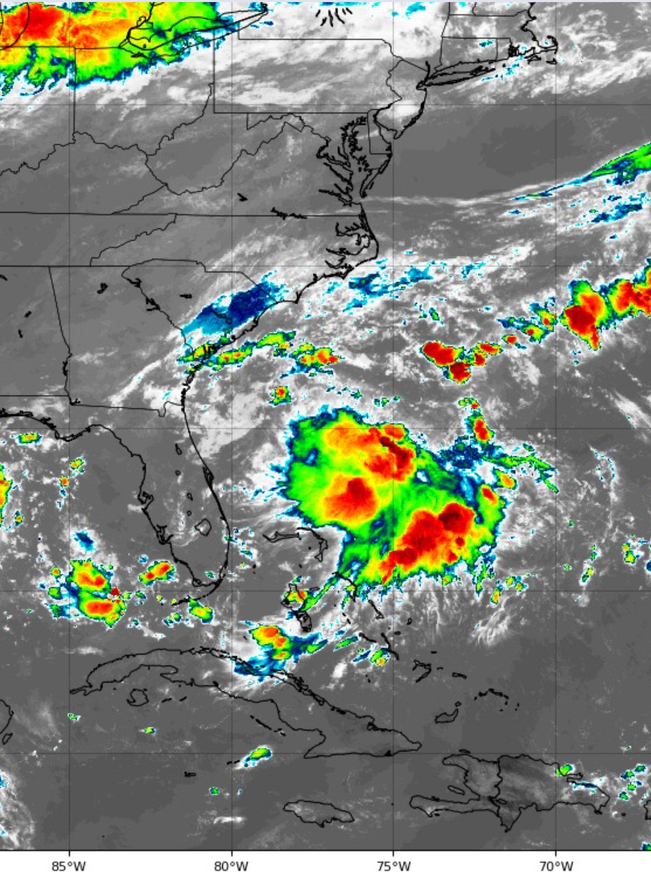
The UK has been hinting at this system forming in front of Dolly along the SE coast. It was kind of a mystery until now but check out this satellite presentation. Looks like it was on to something.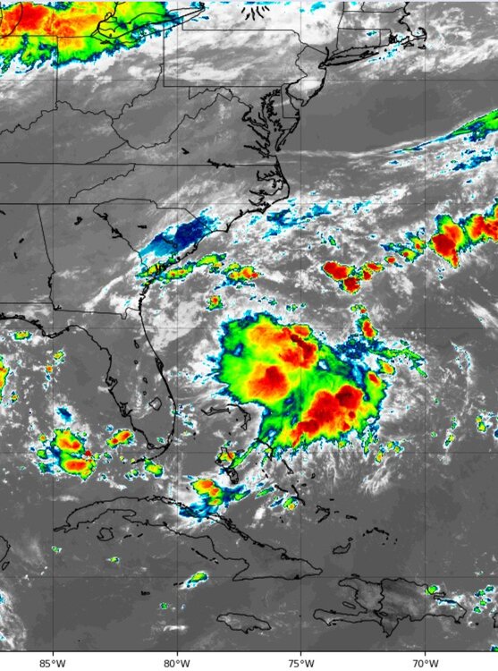
-

Central PA Summer 2026 Discussion/Obs Thread
canderson replied to Voyager's topic in Upstate New York/Pennsylvania
Back into the 90s all week. Mid to upper for some of it. -
Monday, August 31 - Wednesday, September 2, 2026 Convective Episodes
weatherwiz replied to weatherwiz's topic in New England
Morning clouds/rain could certainly a bit of a damper on Tuesday but nonetheless the environment will be supportive so just have to see what kind of recovery can occur. Potential will be NY/PA/western MA/western CT. Unless of course the warm front can sneak a bit farther northeast but the Tuesday AM stuff probably negates that as well. -
(002).thumb.png.6e3d9d46bca5fe41aab7a74871dd8af8.png)
Central PA Summer 2026 Discussion/Obs Thread
ChescoWx replied to Voyager's topic in Upstate New York/Pennsylvania
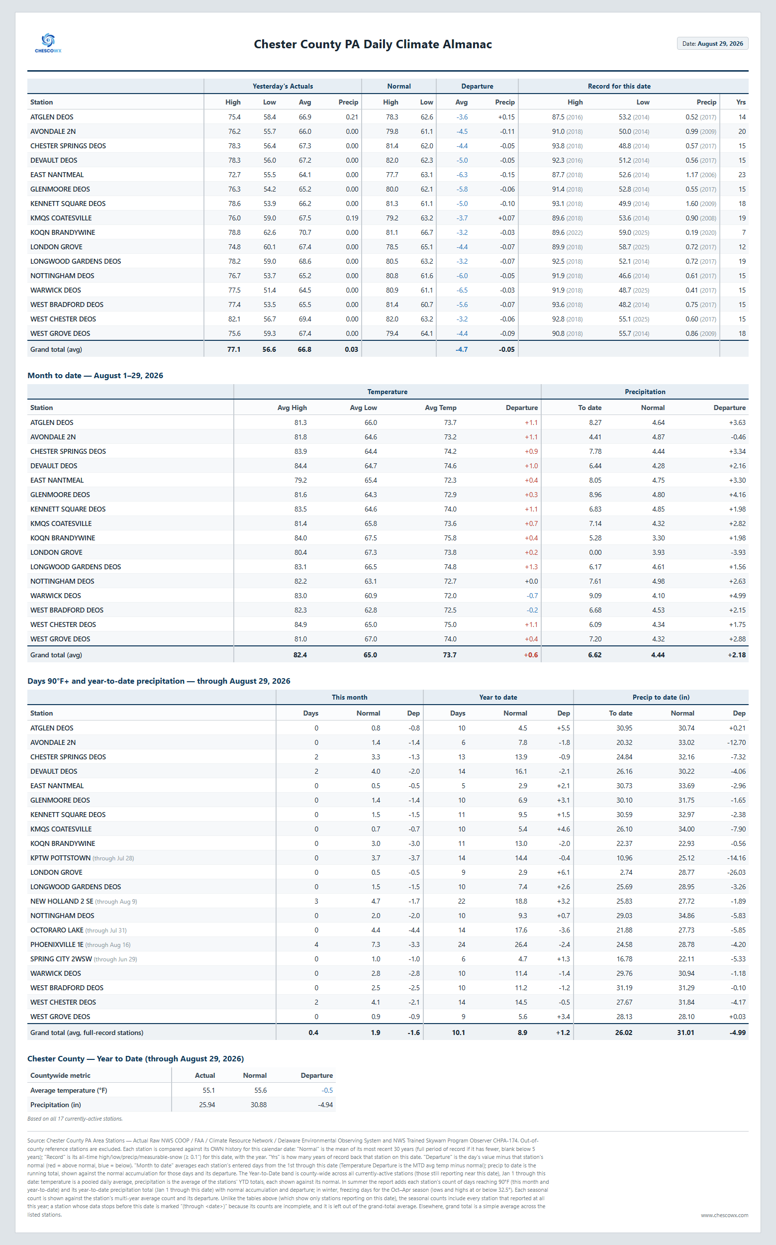
From April through Yesterday most locations are not too far from normal rainfall for the spring and summer to date.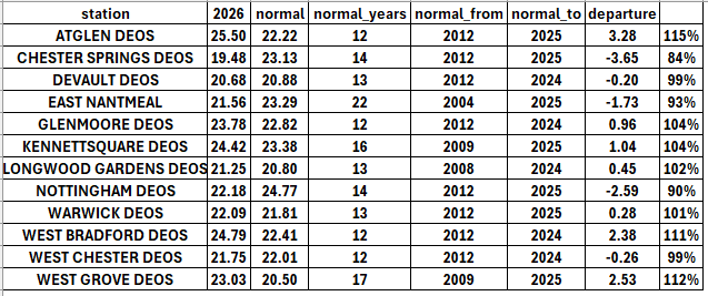
-
E PA/NJ/DE Summer 2026 Obs/Discussion
ChescoWx replied to PhiEaglesfan712's topic in Philadelphia Region
From April through Yesterday most locations are not too far from normal rainfall for the spring and summer to date.
-
A light fog with rain shwrs moving in with temps holding in the 60's overnight into this morning. Come on rain!
-
Rain/sleet/snow/ice. Very mild to very cold. That should cover the bases Thanksgiving week looks colder than the Christmas holiday week. Jan looks to be the coldest month.
-
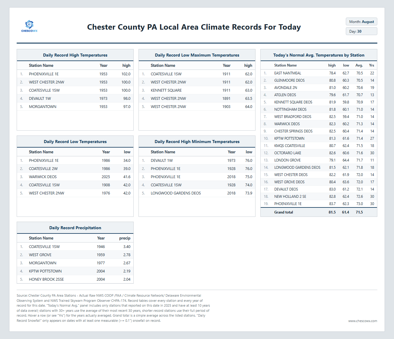
August 30 1977: Flooding occurs on the southwest side of the Twin Cities, with MSP Airport getting 7.28 inches of rain in 4 1/2 hours. For Sunday, August 30, 2026 1776 - General Washington took advantage of a heavy fog to evacuate Long Island after a defeat. Adverse winds kept the British fleet from intervening. (David Ludlum) 1838 - A major tornado, possibly the worst in Rhode Island history, passed south of Providence. It uprooted and stripped trees of their branches, unroofed or destroyed many houses, and sucked water out of ponds. The tornado barely missed a local railroad depot, where many people were waiting for a train. The tornado injured five people. 1839 - A hurricane moved from Cape Hatteras NC to offshore New England. An unusual feature of the hurricane was the snow it helped produce, which whitened the Catskill Mountains of New York State. Considerable snow was also reported at Salem NY. (The Weather Channel) 1982 - A tropical depression brought torrential rains to portions of southern Texas. Up to twelve inches fell south of Houston, and as much as eighteen inches fell southeast of Austin. The tropical depression spawned fourteen tornadoes in three days. (David Ludlum) Record cold gripped the northeastern U.S. Thirty-one cities in New England reported record lows, and areas of Vermont received up to three inches of snow. (The Weather Channel) 1987 - Eight cities in California and Oregon reported record high temperatures for the date, including Redding CA and Sacramento CA where the mercury hit 100 degrees. (The National Weather Summary) 1988 - Thunderstorms drenched Georgia and the Carolinas with heavy rain, soaking Columbia, SC, with 4.10 inches in three hours. Fresno CA was the hot spot in the nation with a record high of 109 degrees. Duluth MN tied their record for the month of August with a morning low of 39 degrees. (The National Weather Summary) 1989 - Thunderstorms developing ahead of a cold front produced large hail in Montana and North Dakota during the evening and early nighttime hours. Hail three inches in diameter was reported 20 miles south of Medora ND, and thunderstorms over Dawson County MT produced up to three inches of rain. Thunderstorms produced golf ball size hail at Roundup MT, Dazey ND and Protection KS. (The National Weather Summary) (Storm Data) Observances: 30 Sun College Colors Day 30 Sun International Day of the Victims of Enforced Disappearance 30 Sun National Beach Day 30 Sun National Grief Awareness Day 30 Sun Frankenstein Day 30 Sun International Cabernet Sauvignon Day 30 Sun International Whale Shark Day 30 Sun National Holistic Pet Day 30 Sun National Toasted Marshmallow Day 30 Sun Slinky Day
-
And the crowd boos Despite the uncertainties, it remains likely that high temperatures will reach the lower to middle 90s for much of the region for much of the new work week. Latest guidance indicates potential for temperatures in the upper 90s to near 100 mid week, so long as it is not disrupted by cloud cover or convection. Depending on smaller scale details, dew points could end up a little higher or lower than currently progged which will ultimately affect how high heat index values get. Values approaching Heat Advisory criteria (100-104 west of the Blue Ridge, 105-109 east of the Blue Ridge) are possible. Temperatures may begin to moderate by next weekend as a cold front crosses the region.
-
Central PA Summer 2026 Discussion/Obs Thread
ChescoWx replied to Voyager's topic in Upstate New York/Pennsylvania
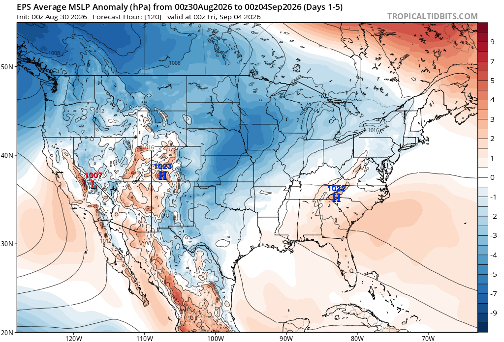
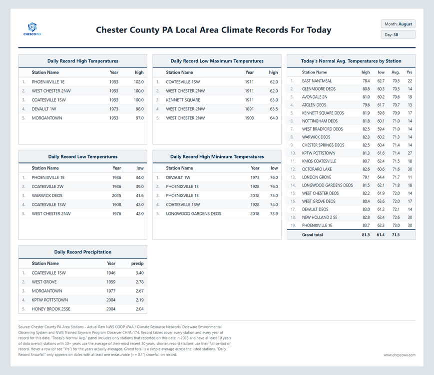
We turn warmer and more humid today through much of the upcoming week with shower and thunderstorm chances each day. The best chances of any rain would be later this evening and again on Wednesday into Thursday. Our warmest day looks to be Tuesday with some lower valley locations possibly touching 90 degrees. We turn much cooler and drier for Labor Day Weekend.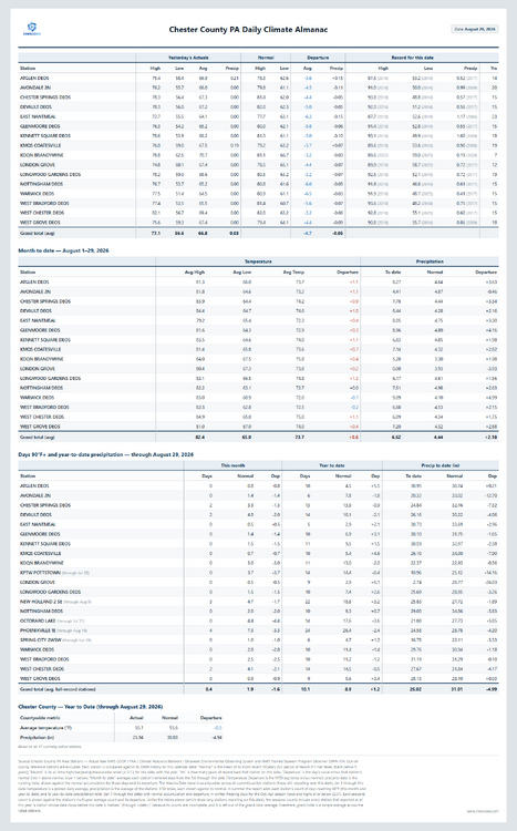
-
E PA/NJ/DE Summer 2026 Obs/Discussion
ChescoWx replied to PhiEaglesfan712's topic in Philadelphia Region
We turn warmer and more humid today through much of the upcoming week with shower and thunderstorm chances each day. The best chances of any rain would be later this evening and again on Wednesday into Thursday. Our warmest day looks to be Tuesday with some lower valley locations possibly touching 90 degrees. We turn much cooler and drier for Labor Day Weekend.