All Activity
- Past hour
-

12/31-1/1 Possible Snow Showers/Squalls to Start 2026
wxmeddler replied to bncho's topic in Mid Atlantic
The snow squall on Thursday pre-sunrise is legit. Might have to set up an alarm for that one. -
Almost, but not yet. But that will come if we fail with snow. Trust me.
-

12/31-1/1 Possible Snow Showers/Squalls to Start 2026
WxUSAF replied to bncho's topic in Mid Atlantic
Love it. Gonna kuchie my way to a 4” seasonal total. -
-
Don't forget bitter. The trifecta.
-
The coastal keeps inching northwest. Most likely nothing.
-
Got me pegged! Lol I'm just getting old and crusty.
-
The semi weenie, optimistic one? Uh oh, what have I just done? BP fastball down the middle.
-
12/30/00 was a really annoying storm in central and east-central MA. Took forever to start (you can see how all the precip filled in west first despite it moving almost due north), and then once it got going it didn’t last all that long. It was heavy but then dryslotted pretty quick.
-

New Years Day 2026 - 1st snows of the new year possible
TauntonBlizzard2013 replied to Baroclinic Zone's topic in New England
If the euro started to strengthen that coastal even 3-6 hours sooner you’re talking probably close to 6” in eastern ma and cape. Obviously a big ask at this lead, but those anomalies are right off the cape -
I'm just tired of getting psyched for something good, only to turn out bad when, in retrospect, I could have seen it coming with a deeper dive. This effin' Niña is killing snow chances. And even if it does snow, they're weak, dry sauce. And the worse part is, we're stuck with it this winter.
-
CPC doing CPC things today.
-
I'll be labelled a deb downer but I'm getting the same feelings I had a couple years ago when we were promised the epic February period. Luckily it's only Jan, so even if it sucks we still at least have February for something. But I'm wary of any map forecasting AN precip in our region. We haven't had that all year outside of some isolated thunderstorms which don't count in January, so I'm side-eyeing that map.
-

January 2026 regional war/obs/disco thread
ORH_wxman replied to Baroclinic Zone's topic in New England
Euro keeps trying to show an IVT associated with the offshore storm on 1/4 as a northern stream shortwave moves over our region to cause it…wouldn’t be much but another inch or two could happen around that time. -

New Years Day 2026 - 1st snows of the new year possible
dryslot replied to Baroclinic Zone's topic in New England
-

12/31-1/1 Possible Snow Showers/Squalls to Start 2026
SnowenOutThere replied to bncho's topic in Mid Atlantic
Euro brings us a small hit tonight -
New Years Day 2026 - 1st snows of the new year possible
ORH_wxman replied to Baroclinic Zone's topic in New England
PVA is pretty damned strong in this. That’s a vigorous vortmax. Could be a quick moderate/heavy burst in there with that. -
He, or or she, is the resurrection of snowman18, who was cloned several years ago into snowman19.
-
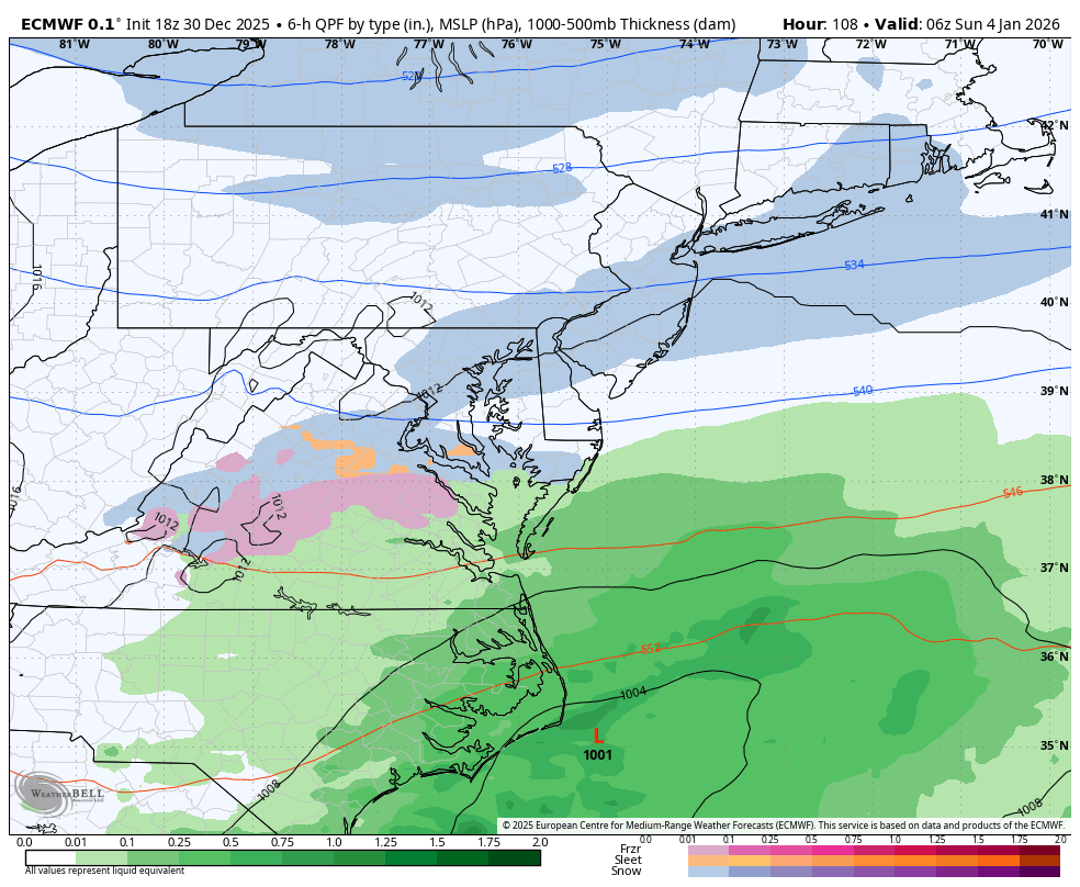
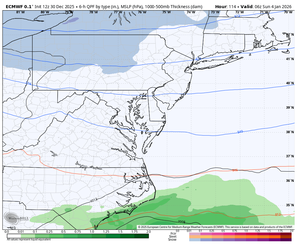
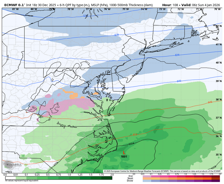
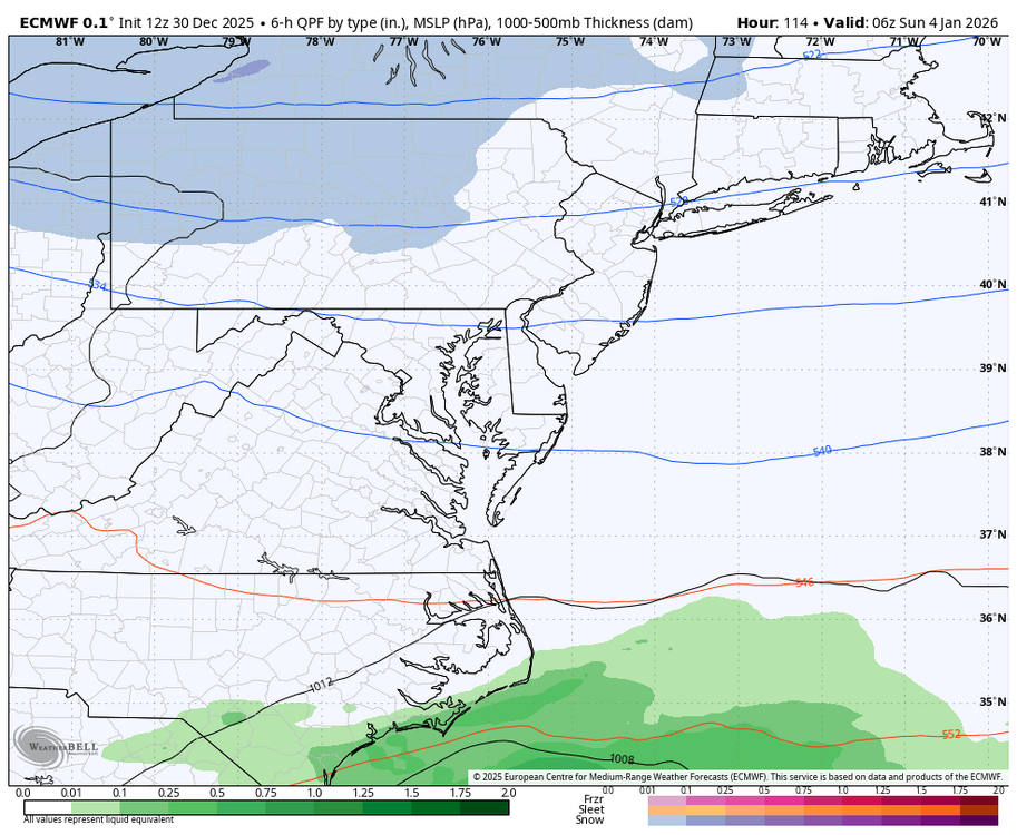
It was not that long ago that the temps on the weeklies showed it would be around the 10th when temps would start to go below average and the pattern would begin to be conducive for snow. If there is no tracking by mid month, I will be disappointed. Until then, patience is needed, and maybe we will get lucky with a small event before then....I am watching Sunday.... WB 18Z EURO compared to 12Z.
-
Maybe the cuts at the NWS nationwide is part of the reason the GFS is bipolar. Truly unbelievable how bad it’s gotten. I never thought the GEM would be scoring better than the GFS. Gracious next will be the JMA outperforming the GFS.
-
I've been complaining about lack of rain since spring. Unfortunately it's getting really bad in my parts. We are way under in precip for the year, and it looks to continue in the new year.
-
Bring back the old Mitch, i liked him SOOOO much more.
-
January 2026 regional war/obs/disco thread
ORH_wxman replied to Baroclinic Zone's topic in New England
ORH has been slightly BN for snowfall in December but not by a lot. November was a goose egg though so seasonal is behind by a 2-3” more. -
I get what you’re feeling @mitchnick, but more often than not since early August the trend has been the other way.
-

January 2026 regional war/obs/disco thread
WinterWolf replied to Baroclinic Zone's topic in New England
Said that a page back Mike…but ya, absolutely.