All Activity
- Past hour
-
15 Second morning in a row Let the warm up begin.
-

December 2025 regional war/obs/disco thread
40/70 Benchmark replied to Torch Tiger's topic in New England
I mean, it's not hopeless....which in and of itself is all you can ask for. -
December 2025 regional war/obs/disco thread
40/70 Benchmark replied to Torch Tiger's topic in New England
Gun-to-head...I think a lot of us pull a white xmas out of our rear stocking. -

December 2025 regional war/obs/disco thread
Damage In Tolland replied to Torch Tiger's topic in New England
Noyes knows -

Central PA Winter 25/26 Discussion and Obs
pawatch replied to MAG5035's topic in Upstate New York/Pennsylvania
6 degrees this morning. With a dusting of snow last night. High yesterday was 22 degrees. -
December 2025 regional war/obs/disco thread
40/70 Benchmark replied to Torch Tiger's topic in New England
Both GFS and EURO OPs (00z) give many a white Xmas.....non-negligible signal at day 9. Euro more xmas eve and GFS Day. -
Hoping for clippers on this flow. I don’t know man. Hopefully Euro AI has a clue.
-
December 2025 regional war/obs/disco thread
40/70 Benchmark replied to Torch Tiger's topic in New England
IDK about the rest of you guys, but in a rudimentary sense...give me volatility, over the single digits on NW flow. -

Central PA Winter 25/26 Discussion and Obs
canderson replied to MAG5035's topic in Upstate New York/Pennsylvania
6 here. -
December 2025 regional war/obs/disco thread
40/70 Benchmark replied to Torch Tiger's topic in New England
For once, I like my locale relative to the rest of SNE...Maine looks to cash in. The further NE away from the ridge, the better the prospects of remaining wintry. -

Central PA Winter 25/26 Discussion and Obs
Blizzard of 93 replied to MAG5035's topic in Upstate New York/Pennsylvania
MDT is down to 9 this morning. -
2025-2026 ENSO
40/70 Benchmark replied to 40/70 Benchmark's topic in Weather Forecasting and Discussion
I will be surprised if we don't see a major SSW and full reversal later this season. -
6z Gfs keeps it seasonal our side of the mountains.
-

December 2025 regional war/obs/disco thread
Ginx snewx replied to Torch Tiger's topic in New England
Volatile. Good luck nailing 23rd to 27th sensible weather. Snow? Ice? Rain? SWFE? Redeveloper? Anything is possible. Difficult but man so interesting from a geeks perspective. Stay tuned. -
2025-2026 ENSO
40/70 Benchmark replied to 40/70 Benchmark's topic in Weather Forecasting and Discussion
2016-2017 lead into another La Nina...not an El Nino. I don't think that really has any value here, aside from the fact that February will often bias the Jan-Feb period warm in the east in a La Nina. 2022-2023 was a deeply +WPO/-PNA season, and I'm quite certain that won't be the case this season. Doesn't mean the second half will necessarily be great, but I don't think much can be gleaned from that particular composite. -
2025-2026 ENSO
40/70 Benchmark replied to 40/70 Benchmark's topic in Weather Forecasting and Discussion
All 6 of those seasons finished with a mean DM -WPO, so this season should, too....though we could have a month or two average +WPO, as was the case in 1990. Looks like I am going to be off on the WPO again...it's so tough to forecast. At least I didn't go strongly positive.... -

E PA/NJ/DE Winter 2025-26 Obs/Discussion
Mikeymac5306 replied to LVblizzard's topic in Philadelphia Region
Had 14F on the way into work. I'm already done with this weather lol. Unless you like 45 degrees and rain, nothing sexy at all long range. -
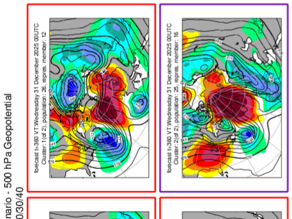
Two clusters on eps cluster analysis in the long range last night. -NAO of unknown impact the general idea. There is a road in some analogs where we start January with a -NAO and as we lose that, the PNA goes positive. Could we take that road this year?
-
18 here
-

December 2025 Short/Medium Range Forecast Thread
Carvers Gap replied to John1122's topic in Tennessee Valley
One thing to watch is how wx modeling responds to potential negatives from the NAO/AO couplet. I highly doubt those details are worked out. Now, an NAO during mid-December is pretty meh in my book, but later in December...it could help. Evidently, I cropped the model information from some of these. The first is the GFS 6z AO plot. The second is the NAO for the 6z GFS. The third is the 0z EPS for the WPO. The fourth is the EPS 0z NAO. The fifth is the AO for the 0z EPS. Those are not bad teleconnections for us. Let's see how modeling builds those into their looks for the medium and LR. -
That was a good watch, thanks for posting it.
-

December 2025 regional war/obs/disco thread
moneypitmike replied to Torch Tiger's topic in New England
If the number of posts reflects the amount of enthusiasm of what the models show, today is about as exciting as Kevin tracking dew points in July. -
December 2025 Short/Medium Range Forecast Thread
Carvers Gap replied to John1122's topic in Tennessee Valley
I also agree the WPO has been a key driver so far this winter. JB has mentioned it a lot. It has been extremely fickle to predict out past two weeks.


