All Activity
- Past hour
-
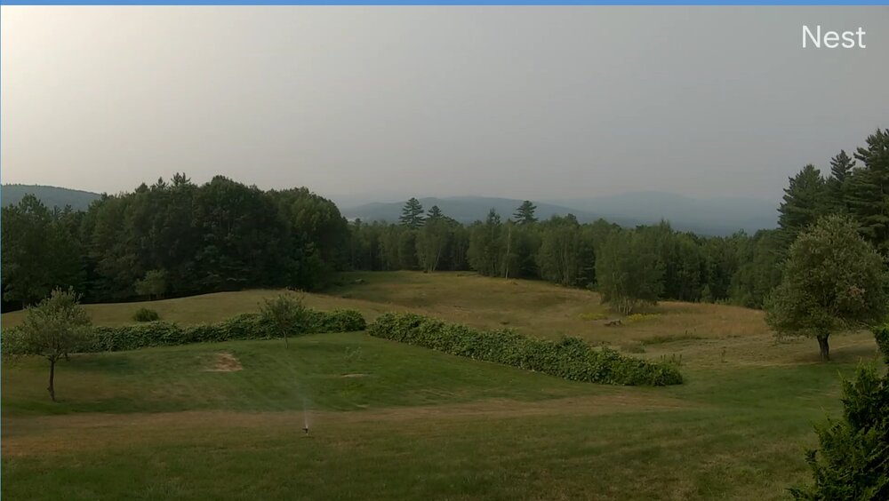
Lots of smoke around.. i don't think I've seen it this bad yet this year
-
 2nd worst air quality in the world for Toronto following the smokiest July on record in Winnipeg.
 -
Coc ks man. Coc ks
-
Nasty day in se nh. Who wanted this and why?
-
 Wait, you live on Long Island?
 -

2025 Lawns & Gardens Thread. Making Lawns Great Again
BrianW replied to Damage In Tolland's topic in New England
@dendrite Just watched this and remember you were growing Chestnuts. Apparently there's 4 trees that seem to be blight resistant so there is hope of bringing them back. https://www.ctpublic.org/shows/human-footprint/clip/the-ghost-tree-bringing-back-the-american-chestnut-mzwjuw -
 Except it does not!! Clearly PHL Airport see below is warming much faster due to the UHI at the airport
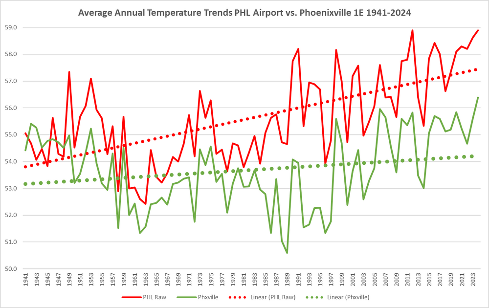
-
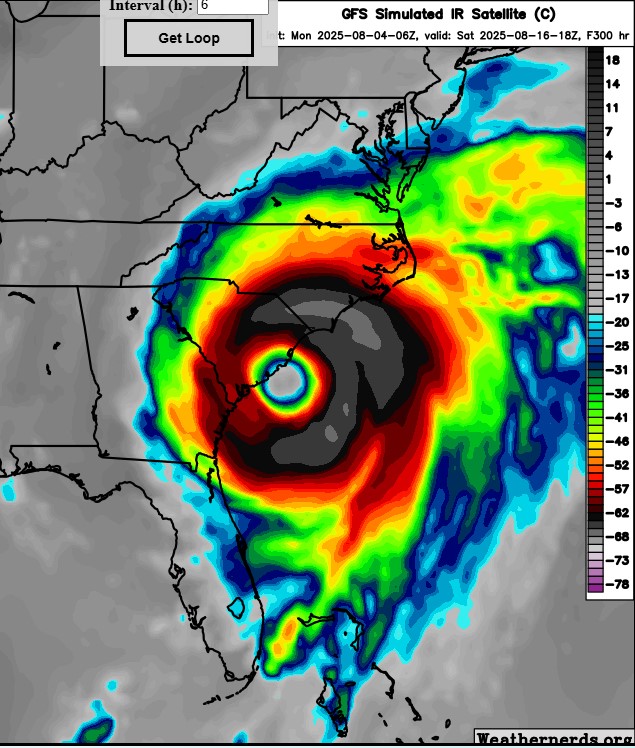
Heading to the Andrea tomorrow.
-
 The best fishing around here is during the colder months. April-June and then October through December.
 -
Those aren’t the people who “love” fishing. Those are casuals.
-
https://phys.org/news/2025-08-plastic-pollution-grave-health-threat.html
-
mm...starting to smack like the high temperatures today will take a hit because of smoke.
-
Beautiful stretch. At PIT, we've doubled our July tally of low temperatures below 60F in the first four days of the month. Happy I've been able to give the A/C a rest for a change.
-
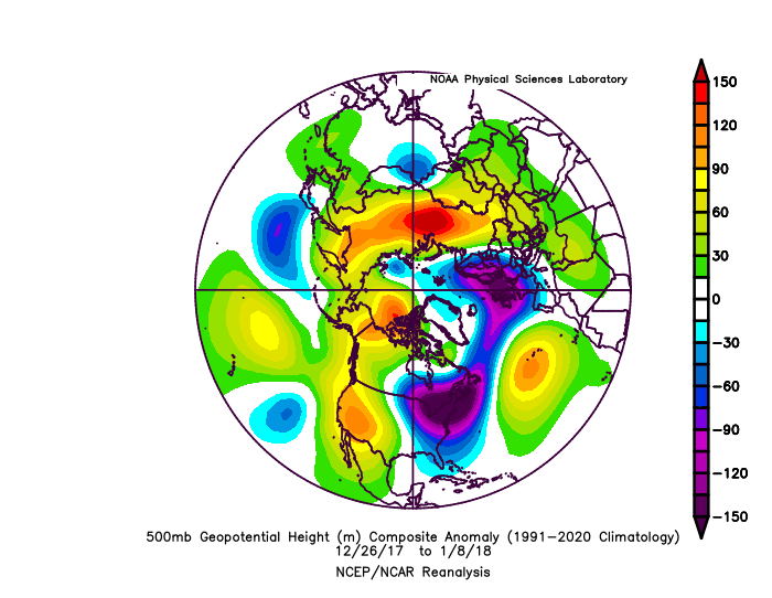
The most significant cold in my area over the last decade was 12-26-17 to 1-8-18. It was mostly Pacific driven. This is why my comment about other factors having a greater influence on the Northeast temperatures than the NAO. You can see the generally lower heights over Greenland to Iceland. The best blocking was over Western North America. Time Series Summary for NY CITY CENTRAL PARK, NY 10 coldest 12-26 to 1-8 periods on record Click column heading to sort ascending, click again to sort descending. 1 1918-01-08 13.4 0 2 2018-01-08 17.9 0 3 1904-01-08 20.6 0 4 1881-01-08 21.9 0 5 1879-01-08 22.2 0 6 1887-01-08 22.4 0 7 1981-01-08 23.7 0 8 1940-01-08 23.9 0 9 1968-01-08 24.2 0 10 1877-01-08 24.6 0
-
I just looked at the national weather map and hadn’t realized how bad the smoke was in the northeast and around the Great Lakes.
-
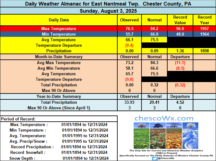
The first 3 days of August have featured temperatures nearly 10 degrees below normal. We see temperatures rebound this PM to near normal with highs in the low to mid 80's. Similar temperatures tomorrow before we turn again a few degrees below normal to close out the work week. Near normal temperatures return next weekend. Rain chances look slight but more clouds and maybe a shower on Wednesday.
-
E PA/NJ/DE Summer 2025 Obs/Discussion
ChescoWx replied to Hurricane Agnes's topic in Philadelphia Region
The first 3 days of August have featured temperatures nearly 10 degrees below normal. We see temperatures rebound this PM to near normal with highs in the low to mid 80's. Similar temperatures tomorrow before we turn again a few degrees below normal to close out the work week. Near normal temperatures return next weekend. Rain chances look slight but more clouds and maybe a shower on Wednesday.
-
Yep that was intense. Had numerous trees down in my neighborhood too. As usual with the east side of any tropical system here-a couple showers but very high wind. Luckily it didn’t hit NC as a borderline cat 2/3, in that case power here could’ve been off for weeks.
-
 2 fish storms, possibly 3, depending on how close to shore the one off the SE coast forms, if it forms.
 -
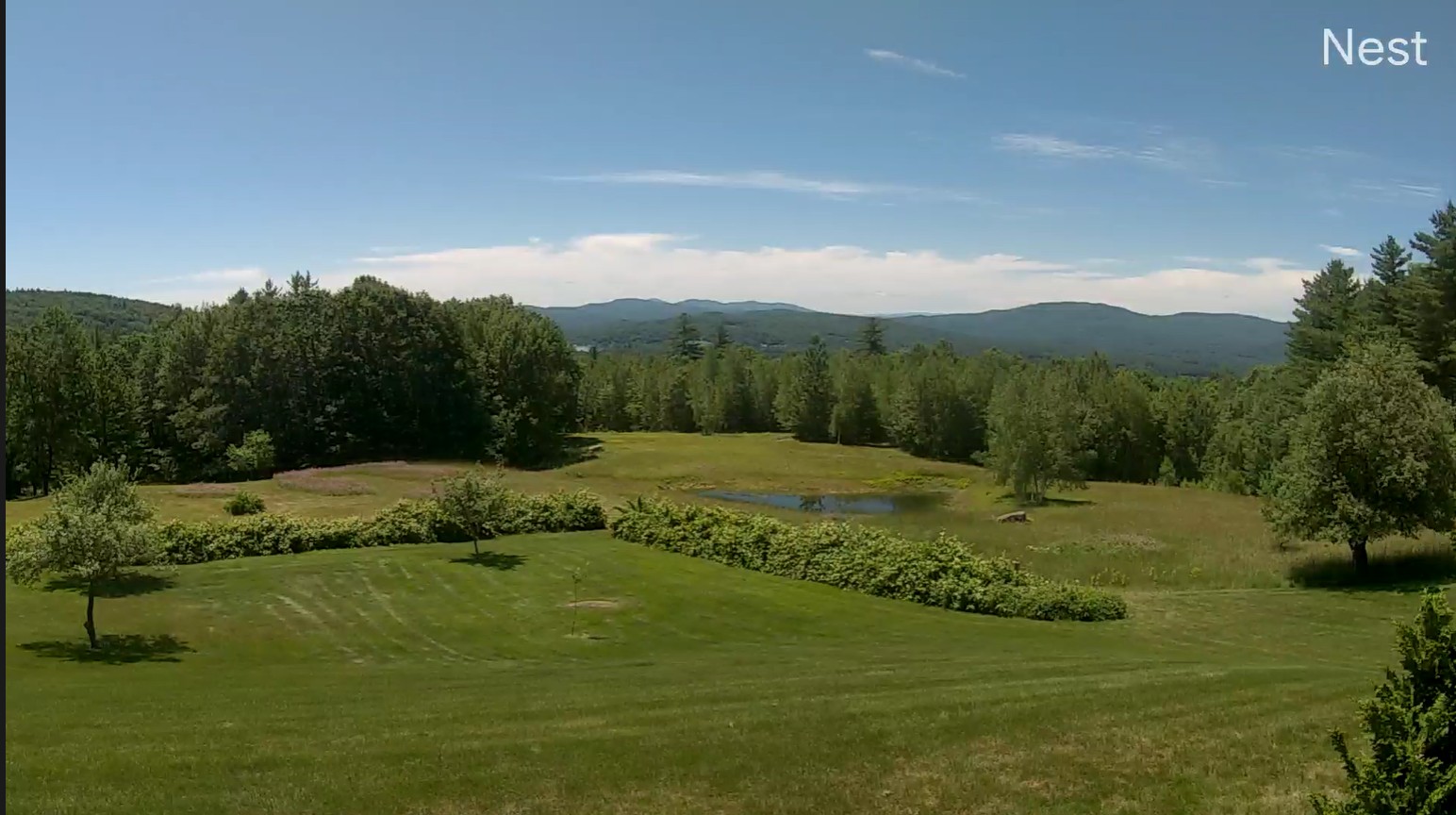
Good day view and this morning but not a cloud to be found

-
Roofers are crazy brave dudes. That is all.
-
krispy erin
-

2025-2026 ENSO
PhiEaglesfan712 replied to 40/70 Benchmark's topic in Weather Forecasting and Discussion
Last cold winter month, yes. But there have been really cold months since JFM 2015, albeit in other seasons, like April 2018, November 2018, November 2019, and June 2023. -
The wind held off in Queens until that line of storms rotated through with the circulation toward the end of the event. Our strongest winds came with sunshine ironically, but they were really strong, the airports gusted to 70mph.
- Today
-
Starting next Monday we torch for a week or 10 days then finish out with some more AN days August +1.5