All Activity
- Past hour
-

2025-2026 Fall/Winter Mountain Thread
nchighcountrywx replied to Buckethead's topic in Southeastern States
Official Guidance from NWS GSP: Key message 2: Accumulating snowfall is expected to begin Wednesday afternoon at high mountain elevations along the TN border. Snow level falls over the mountains as temps cool through the evening. Appreciable accumulations and the most significant travel impacts still look to be confined to elevations above 3500 feet. Flurries cannot be ruled out Wed night or early Thu morning in the Piedmont, though accumulation is not currently expected. As noted in previous forecast cycles, a compact southern-stream shortwave over the western Gulf Coast will phase with and be absorbed by a substantially deeper shortwave associated with an Arctic cold front tonight into early Wednesday. Low- to mid-level flow will back and amplify over the CWA during this time, ahead of the trough axis. Moisture return is limited at or below 850 mb, though by Wed morning deep saturation is seen above 800-700 mb; left-exit region of southern stream jet streak somewhat overlaps with right-entrance region of the northern one to concurrently bring some dynamic lift across GA and the Carolinas, which results in light QPF response near our southeastern CWA border in some models. This would be of little consequence given temps well above freezing in those areas. Saturation occurs closer to the surface during the afternoon just ahead of the surface front such that mentionable PoPs develop over the mountains; RH will be high at ice nucleation temperatures well aloft, so snow is possible wherever temps are cold enough in the PBL. Only the highest peaks appear likely to be cold enough for snow at onset, though rates greater than an inch per hour appear possible there. CAA from around 21z onward should begin to bring the snow level lower, particularly considering the wet-bulb temp profile, though temps still don`t cool fast enough to allow accumulation to begin in the valleys until after 8 PM. Lift will be enhanced for a time as the base of the shortwave shifts overhead, though drying quickly occurs aloft behind that. However, with temps continuing to fall and still decent low-level moisture, the PBL cools to support ice nucleation near the surface, with the needed lift then mainly resulting from NW upslope flow. Snow rates decline where NWF is not a factor. With strong (near-advisory) winds/gusts continuing, the upslope factor is respectable, and near 1"/hr rates look to continue on the peaks until the low levels too dry out after midnight Thu morning; additional accums after that time appear on the order of an inch or less, even in the higher elevations. Altogether it still appears this will be a highly elevation dependent event. Event totals of 4 to 8 inches now are expected in the highest elevations of the Smokies, with 3 to 6 inches on some of the higher peaks in the northern mountains and near Mt Mitchell. The larger cities in the mountain zones may not even see an inch per the current forecast, and averages for the lower-elevation portions of the zones are well below the 2 inch threshold for Winter Wx Advisory. Hence no Advisory is being hoisted at the current time, per local policy of considering the above- and below-3500 ft averages. Avery is considered as one zone as usual and does not meet the 2 inch criterion either. All this said, even the light accums may lead to some travel issues given overnight temps falling mostly into the teens, so will continue HWO mention. For the Piedmont, 15-30% PoPs are warranted Wed evening ahead of the base of the shortwave, though temps will be too warm for anything but rain at that time. Most model depictions show the cold air just barely chasing the precip, and particularly with saturation aloft and wet-bulb profiles near freezing down to the surface, it is reasonable to expect a few flurries will be seen. With the late overnight onset of subfreezing sfc temps, however, and the very light QPF depicted from those models producing it at all, any accumulation looks unlikely. Did see fit to add a flurry mention for the eastern I-85 and I-77 corridors where the overlap looks most likely to occur. Key message 3: Wind chills late Wed night and early Thu morning could prove dangerous in some higher elevations, requiring adequate protection from winter clothing. As noted above, winds will be near Advisory criteria in higher mountain elevations, where temps will fall into the lower teens (upper single digits above zero above 5000 ft). Resultant apparent temperatures fall into the -5 to -15 range which would support Cold Weather Advisory. Confidence is moderately high for such conditions above 3500 ft, but not yet confident if lower elevations may meet criteria. There remains time for re-evaluation on tonight`s forecast cycle, so will let the next shift take a look. Key message 4: Significantly colder temperatures continue Thursday through the weekend, albeit with a slight warmup on Saturday. Dangerously cold wind chills will be possible above 3500 ft Saturday night and Sunday morning. Any lingering light snow showers/flurries should end Thursday morning as moisture dissipates. The bigger story will be a cold air mass that moves in behind a departing cold front. Highs Thursday will be much colder than Wednesday, as much as 15 to 20 degrees below normal. Lows Thursday night will also be as much as 15 to 20 degrees below normal With winds diminishing overnight, locations with 5 below wind chill values should be limited to mainly locations above 4000 feet. Temperatures moderate Friday and Saturday high pressure moves east and a southwesterly flow develops. Lows Friday night and highs Saturday will range from near normal to up to 5 degrees below normal. Highs Saturday will be near normal with steady for slightly lower temps across the mountains. Another cold front crosses the area late Saturday or Saturday night bringing cold temperatures back into the region. Lows Saturday night through Monday nights will be nearly steady 10 to 15 degrees below normal. For now, winds appear to be low enough to keep wind chill values out of advisory territory for all but the highest peaks. Highs Sunday will be 15 to 20 degrees below normal then 5 to 10 degrees below normal Monday and Tuesday, with Monday the warmer of the two days. Key message 5: A clipper type low pressure/cold front may bring some light snow to the mountains Friday night possibly into Sunday. The cold air mass mentioned in the earlier key message will be proceeded by a clipper type cold front. The guidance varies greatly regarding this feature. The GFS favors a double barreled system with light snow showers for the mountains Friday night and early Saturday, then the second system on Sunday. The Canadian has a stronger system Friday night and Saturday with some precip spreading out of the mountains, then a series of weaker systems through Tuesday for mainly the NW flow precip areas. The ECMWF is similar to the GFS for Friday night and Saturday then a weaker system on Monday similar to the Canadian. And just to make things even more uncertain, the Canadian and GFS have a different flavor of a weaker font/clipper for Tuesday while the ECMWF is dry. The LREF mean shows light precip Fri nite/Sat then again Sat nite/Sun. The GEFS mean shows a light mountain event Fri nite/early Sat then a stronger event Sun/Sun nite. The Canadian ensemble mean shows a stronger event Fri nite/Sat with a weaker event Sat nite/Sun. Obviously, this makes for a confusing and low confidence forecast. As usual in these situations, have followed the model blend which shows light snow potential for Fri nite through Sat night with the possibility of some precip escaping the mountains across the I-40 corridor Saturday. Stay tuned as this will likely change. -
Okay
-
As long as it doesn't involve 'orange' juice (I.e. AN) on the temp-side, I'll take whatever the STJ can offer. CMC Ens #12 and #16 look pretty darn good.
-
3 things are certain in life. Death, taxes and a greyhat post about conditions in delware.
-
In fact, latest Icon model has rain and 40 degrees for Sunday the 18th. Steady snow inland. Time is running out
-
Correct. Cold”er” seems like a lock; but clearly not that cold because it can’t even support snow Very reminiscent of January and February 2019. Warm and wet and cold and dry.
-
Not sure why the Harbaugh's love Roman, but watching that game reminded me of the Raven's playoff appearances with Roman as OC. Jim must have had enough because Roman just got fired today. Maybe Herbert refused to play another season with him.
-

January 2026 regional war/obs/disco thread
HoarfrostHubb replied to Baroclinic Zone's topic in New England
I’ve yet to trust the ICON -

January 2026 regional war/obs/disco thread
ORH_wxman replied to Baroclinic Zone's topic in New England
Yeah that was a pretty decent trend toward those GEFS members on the icon. Want to see euro get more enthused though. -
Not a bad look upstairs.
-
March 1-2, 1980 might have an intellectual property claim against the AIFS.
-
Cape storm trying
-

January 2026 regional war/obs/disco thread
ineedsnow replied to Baroclinic Zone's topic in New England
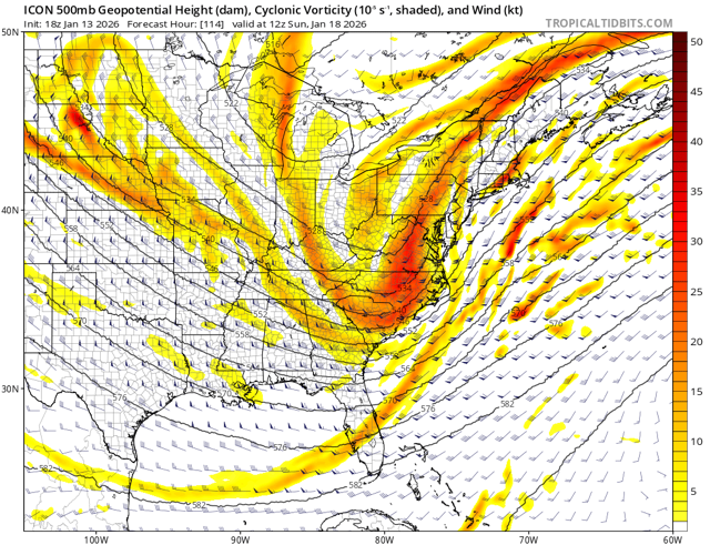
ICON for Sunday.thumb.png.9714f5d8db07ea3aa1a5cff2720ef642.png)
-
Euro Weeklies Control: The overall Weeklies pattern is BN precip over the SE. That isn't always a bad thing as snowy regions won't usually show up as AN for precip...but precip probably is going to be an issue at times. Here is a fun little map. This is a 30 day map from the control run of the Euro Weeklies. Benchmark storm signal present on a 30 day map. Please be sure to temper expectations....we know how modeling has been this winter - not exactly reliable. But I do like the Euro a little bit in the middle of winter while wavelengths are longer(are they really longer right now?!). If the STJ finds some juice???
-
I think they're too low on Amounts for Plateau and upper Valley Locations. We got 1/4-1/2 inch Sunday and they were saying no accumulation. With the NWF Snshwrs after the synoptic shield leaves there should be scattered additional accs from those. That's not mentioned in their discussion.
-
Fwiw, 18z Nam gives the combined metro areas a coating to at most an inch tomorrow night, and the Icon refuses to give up on the Cape storm for those N and W, with far NW favored.
-
Through tomorrow, highs will generally reach the 40s during the daytime and 30s for lows in New York City. Some light precipitation is possible tomorrow evening into Thursday. Rain showers could transition to a period of snow or snow showers, especially well north and west of New York City where a light accumulation is possible. Afterward, temperatures will "step down" with highs mainly in the middle and upper 30s in New York City and lows in the lower and middle 20s. Some teens are likely outside of New York City. Flurries and perhaps a heavier snow shower are possible on Saturday and Sunday as a renewed flow of cold air moves across the region. Temperatures will remain below normal through at least early next week. After January 20th, conditions might become more favorable for both cold and snowfall, especially if the PNA remains predominantly positive, as has often occurred following the breakdown of long-duration PNA- regimes. PNA-related developments would have larger implications for snowfall. A persistently positive PNA would have above climatological risk of moderate or significant snowfalls. A mainly negative PNA would favor mainly small snowfalls. It will likely be another day or two before the guidance reaches the high-skill timeframe for teleconnection forecasts related to closing days of January. The ENSO Region 1+2 anomaly was -0.7°C and the Region 3.4 anomaly was -0.8°C for the week centered around January 7. For the past six weeks, the ENSO Region 1+2 anomaly has averaged -0.47°C and the ENSO Region 3.4 anomaly has averaged -0.67°C. La Niña conditions will likely continue into at least late winter. The SOI was +8.91 today. The preliminary Arctic Oscillation (AO) was -0.667 today. Based on sensitivity analysis applied to the latest guidance, there is an implied near 58% probability that New York City will have a cooler than normal January (1991-2020 normal). January will likely finish with a mean temperature near 33.3° (-0.4° below normal). Supplemental Information: The projected mean would be 0.7° above the 1981-2010 normal monthly value.
-
The Euro Weeklies turned sharply colder this afternoon. That makes sense given how cold the 0z run was(and 12z supported it). The 30 day mean 500 pattern is a trough over the eastern US. There will be a few warmups embedded as the trough tries to stick into the West, but the cold centered in the Canadian Plains and tundra is going to want to run this show - Nunavut, Manitoba, Ontario, Quebec. The BN 500 heights are going to almost force a trough in the East as long as its there. The SER will surge NE at times, and then should get beaten back down. The block over the top should continue to allow for the EPO to hold in place. The Weeklies hold this pattern for nearly the entire 46day run(with variations and ebbs and flows) which likely is not accurate, but if it was.........cold period incoming. Somewhere Larry Cosgrove has to be smiling - big tip of the hat if he pulls this off.
-
As many reasons as there are ensemble members, and then some.
-
Apri is usually a nice month here. 60's low humidity and cool mornings. May is usually not too bad either
-
Hot donuts sign is on.....
-
I don't see it, looks like rain back to Albany
-
Only a cutter on the 23rd and suppressed on the 27th
-
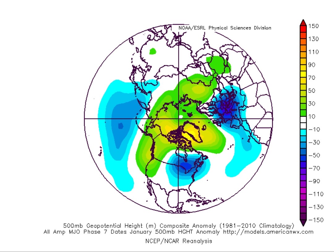
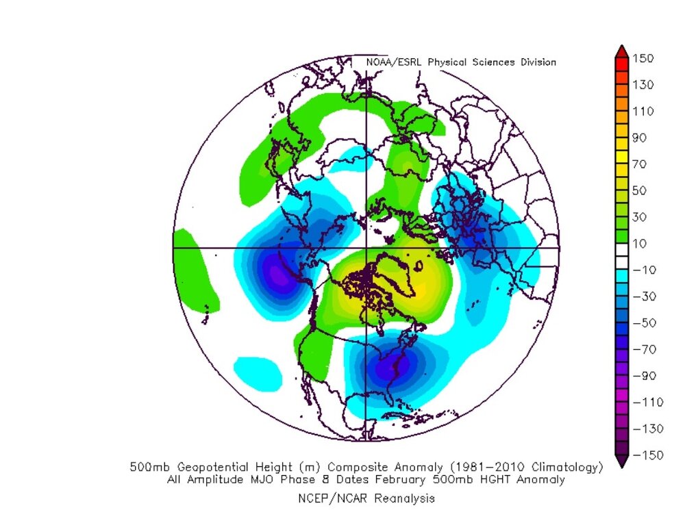
MJO phase 7-8, January analogs

-

Pittsburgh/Western PA WINTER ‘25/‘26
colonel717 replied to Burghblizz's topic in Upstate New York/Pennsylvania