All Activity
- Past hour
-
What the!?!
-
Euro AI brings in another Winter Storm mid next week.
-
Euro ai 6z is a weenie run. Smokes us this coming weekend then another hammer a few days later.
-
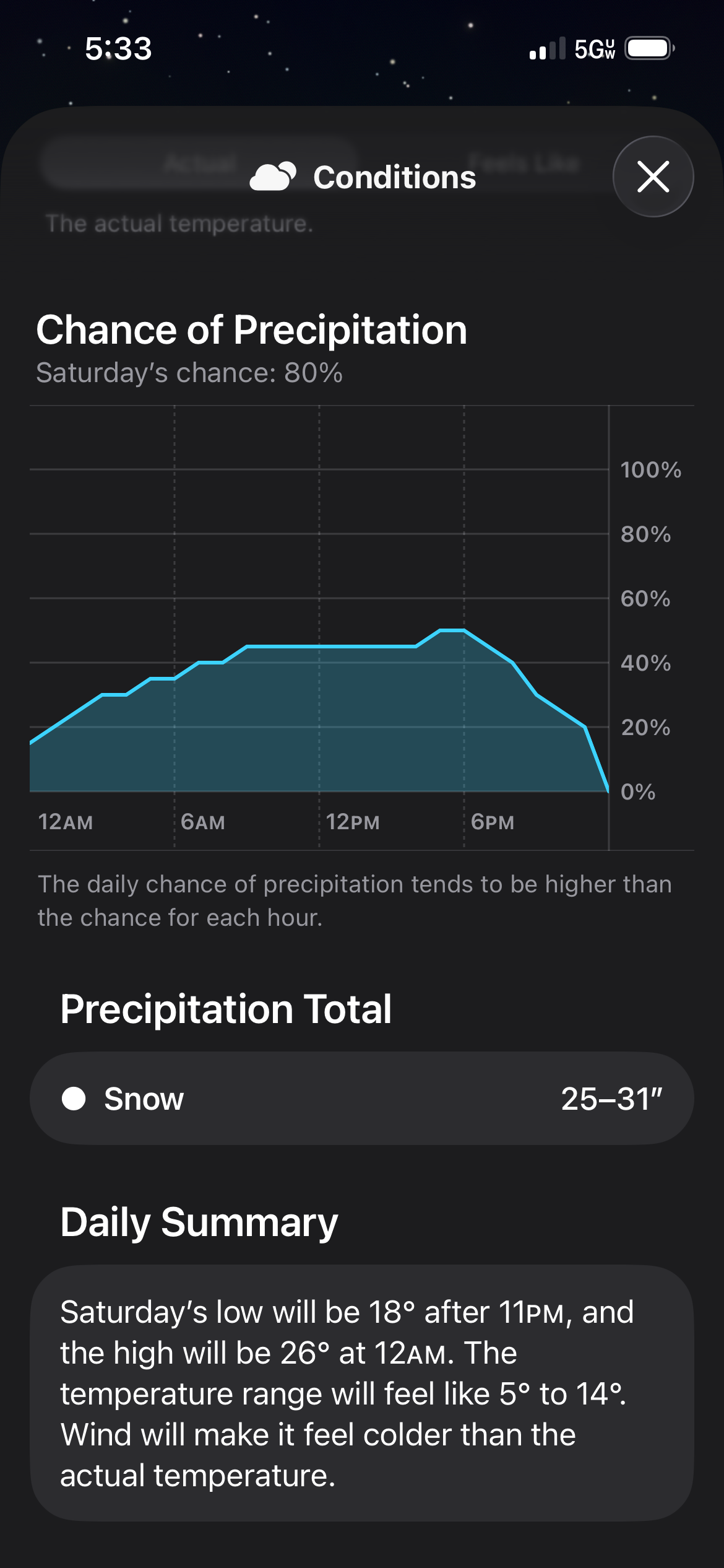
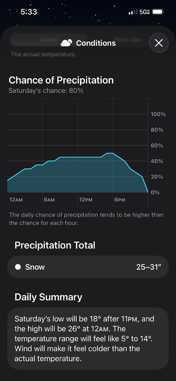
6z Euro AI is just to far north for snow on most of this board. Plenty of ice though taken literally
-
I think at this point we still put 100% stock in ensembles and EPS and GEFS is keeping everything south. I'd like to see individual members if anyone has them.
-

E PA/NJ/DE Winter 2025-26 Obs/Discussion
Duca892 replied to LVblizzard's topic in Philadelphia Region
In your experience and with the AI scores do you expect the GFS to follow them? I actually keep meaning to tag you because you did a great job mentioning possible suppression a few days ago -
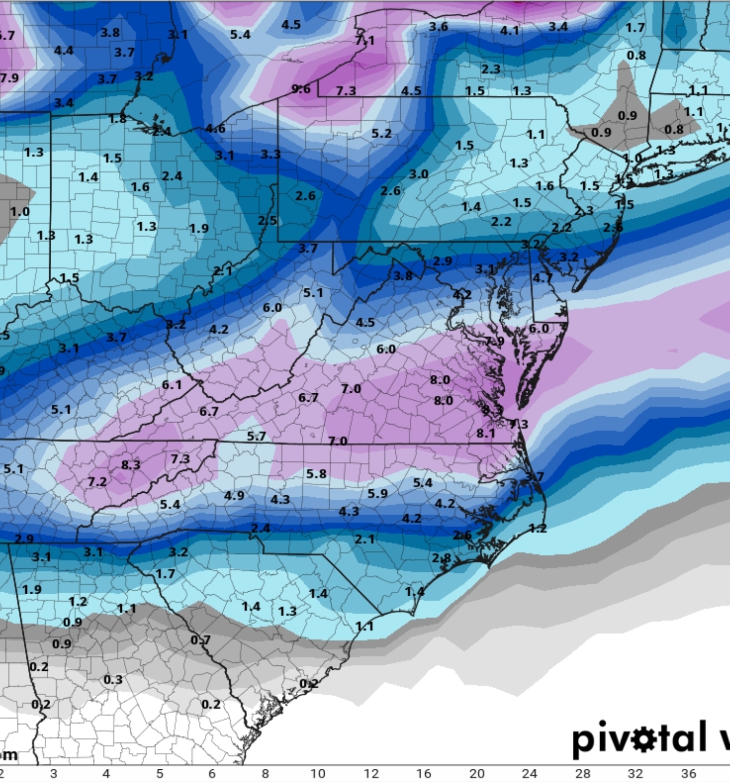
6z GEFS, 6hr precip. This gives you a good idea of precip location and movement.
-
This post stuck with me considering the AIs are being so consistent
-

Winter 2025-26 Short Range Discussion
A-L-E-K replied to SchaumburgStormer's topic in Lakes/Ohio Valley
Explains the fresh dab and hoth aura out there this morning -

E PA/NJ/DE Winter 2025-26 Obs/Discussion
Ralph Wiggum replied to LVblizzard's topic in Philadelphia Region
Ensembles are North and the AI models are way North. AIFS is a massive hit here and the AIGFS is a crippling ice storm respectively: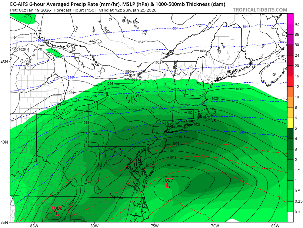
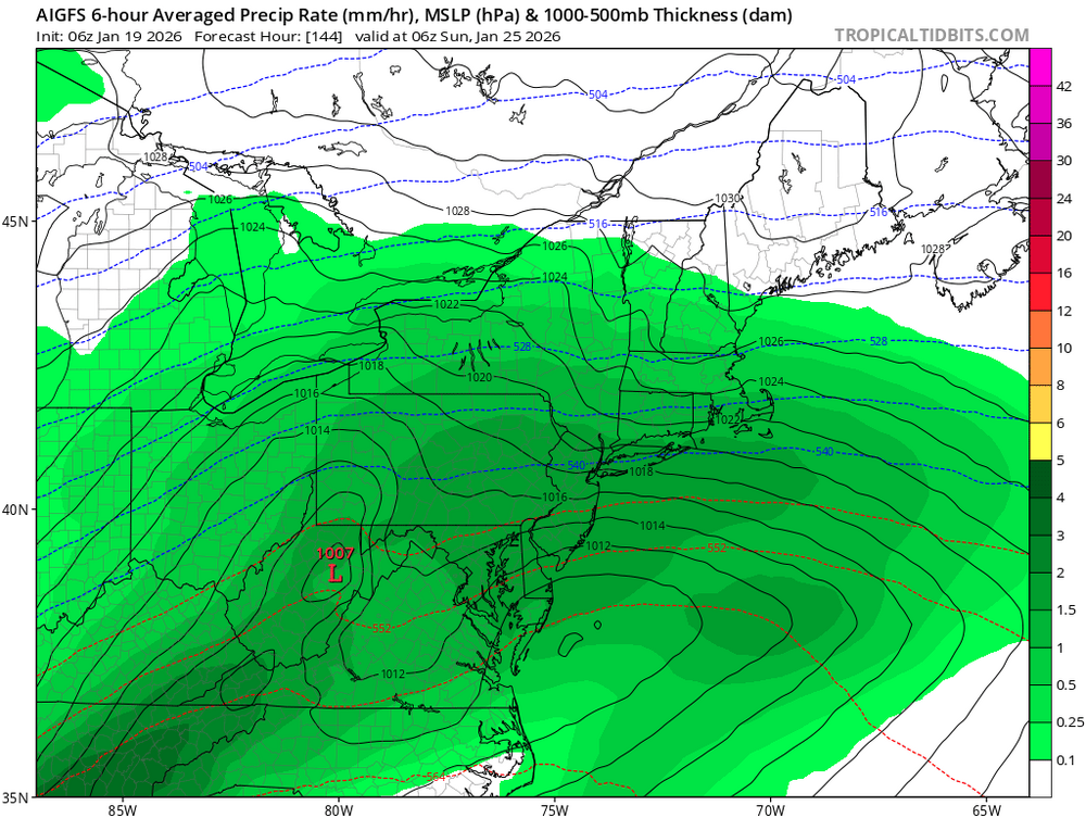
-
Rise of the Machines: January 18-19 Winter Storm Obs Thread
CarverWX replied to WxWatcher007's topic in New England
Just measured 5.25" -
Love to see a snow map for that. Looks juiced up!!!
-
Has a second major snow mid next week. What a weenie run.
-
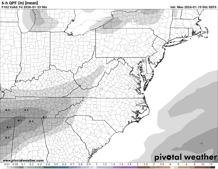
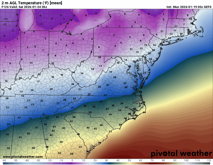
6z GEFS temps through out the heart of the storm.
-

January 2026 Medium/Long Range Discussion
Stormchaserchuck1 replied to snowfan's topic in Mid Atlantic
With a 1040mb High to the north as it starts.. close to blizzard -

January 2026 regional war/obs/disco thread
Damage In Tolland replied to Baroclinic Zone's topic in New England
6z GFSAI has a big hit -

January 2026 regional war/obs/disco thread
SouthCoastMA replied to Baroclinic Zone's topic in New England
The 6z euro AI is something. Good to see the AIs persistently north of OPs at 6z again -

2025-2026 Fall/Winter Mountain Thread
Buckethead replied to Buckethead's topic in Southeastern States
9 this morning in Wolf. Sent from my Pixel 10 Pro using Tapatalk -

Rise of the Machines: January 18-19 Winter Storm Obs Thread
jculligan replied to WxWatcher007's topic in New England
4" in Salem NH. 7.5" for the weekend. 6" depth in the yard. -
Still a ways to go this week but 1 thing i dont like is the Euro AI and GFS AI cutting west of the apps and bringing more sleet/ZR than snow. Plenty cold at the surface but aloft that would make for more ice.
-
WBAL mentioning the threat for the weekend
-

Central PA Winter 25/26 Discussion and Obs
mahantango#1 replied to MAG5035's topic in Upstate New York/Pennsylvania
Wxrisk.com · Shared with Public TIME TO START TO TALK ABOUIT JAN 25 NEXT WEEKEND In January 5-6 edition of the NEXT 3 WEEKS Newsletter I discussed three possible East Coast winter storm threats (THREATS= chances) JAN 15-16… JAN 18- 19… JAN 23-25. And I stated SEVERAL times in those newsletters and on the videos that the problem with the first two events was that the MJO was going to be either Phase 6 or Phase 7 and that's not good for East Coast snowstorms. (January / PHASE 6 / La Nina 500mb pattern = VERY unfavorable. The one I was really focused on was Third possibility or threat around January 23-25. But that was based on the hope or belief that MJO will be moving either from Phase 7 into Phase 8 or in Phase 8. Based upon all the current data that appears to be exactly what is happening. IMAGE 1 is the snowstorm Bible. It is a 2 Volume study produced bn the AMS written by snowstorm specialists Paul Kocin and Dr Lewis Uccellini. It covers 33 major East Coast snowstorms since 1950… up through 2005 . Obviously there have been several winter storms since then so at some point the book may be upgraded again. In studying East Coast snow storms you learn a few things. One is that the vast majority 25 of the 33 occur when the MJO is in Phase 8 or 1 with some East Coast snowstorms occurring in Phase 2 or Phase 7. Second things about Big East Coast sno storms is that happen when the normal jet stream pattern across North America is disrupted by strong blocking in Greenland or having a giant ocean low that is over Southeastern Canada such as Nova Scotia or Newfoundland AND by having Arctic air Displaced out of Canada deeper into the US. As you may know right now, most of the eastern CONUS are experiencing drought conditions. Even though the winter has been cold y east of the Mississippi River and on the East Coast in particular… it has been extremely dry. This is due in part to La Nina. However, with La Nina weakening the strongly indicates the MJO to move into phase 8 in late January and a good portion of February and then moving to Phase 1 IN he second half of February. SEE IMAGE #2 Does this guarantee a snowstorm for the East Coast? no of course not . Does it increase the probability ? Yes it does. TOO MUCH COLD AIR ? Yes of course that is a problem during the winter season. A lot of people get really excited about big arctic outbreaks and they are important since they can cause heating bills to rise, disrupt plans, shut down schools, and cause all sorts of infrastructure problems. But having a persistently cold pattern with the Arctic air pouring out of Canada -- essentially a dominating Northern jet stream pattern = cold and dry. In short a pattern which does not produce East Coast snow storms. If you are a long-term follower WXRISK then you know I said for many years and in many videos that *** SPLIT FLOW WEATHER PATTERN ** are really good for the East Coast In terms of producing significant winter weather. Of ourse this depends on some Arctic air just not too much. Having buckets of art of gear pouring out of western Canada doesn't do anything except make the pattern cold and dry.. IMAGE 3 is the 500mb European model valid for Friday January 23rd. It is an extremely impressive winter storm pattern for the East Coast. The Polar Vortex is located just north of the Great Lakes which is extremely far south. But more importantly the jet stream pattern has split. The key to this event occurring is going to be the UPPER LOW off the southern CALF coast and how it interacts with the Polar Vortex in the northern Jet Stream as it comes East and tracks across Texas and the Gulf Coast. IMAGE 4 = shows the early morning European model from Sunday and then the new afternoon run (0z and 12Z) . The early morning Sunday European model suggests that the southern CALIF LOW is going to come far enough north to drive warm air into the middle levels of the atmosphere. If so then the Mid-Atlantic would be hit by is a long duration serious heavy ice storm with significant power outages and all sorts of infrastructure problems with heavy snow OH PA NY New England . The 12z Sunday afternoon European has a major snowstorm for the Mid-Atlantic because California LOW tracks for the South. The LOW tracks further south because the Polar Vortex is stronger and bigger. SUMMARY January 25 event was one of the three events I talked about in early January that would occur this month. The first two were misses and did not really happen as I thought. This one -JAN 25- however has a better chance because of the MJO going into the favorable phase 8. And the development of a split flow pattern. Right now all I will say is that the pattern looks really great for next weekend for some kind of significant winter weather in the Ohio Valley the Mid-Atlantic and New England. But that is s all I am saying. It could be snow… it could be ice …it could be a combination. 3 KEYS The MJO has to go into phase 8. The pattern has to develop a split flow on the west coast of North America. The Arctic air has to be in place across the Great Lakes in New England but not too much are together to push everything to the South and crush the southern system -
6z GEFS

-
Rise of the Machines: January 18-19 Winter Storm Obs Thread
Damage In Tolland replied to WxWatcher007's topic in New England
That all is absolutely fantastic -
Rise of the Machines: January 18-19 Winter Storm Obs Thread
Damage In Tolland replied to WxWatcher007's topic in New England
There you go Bear! Enjoy !