All Activity
- Past hour
-
Steady rain again i suppose if it's going to be mid upper 90s soon i'm happy to get as much ground water as possible. I do need to mow though
-
Ok wow I am surprised to see In picked up .59” after midnight. Knew we would get some rain but not that.
-
Very strong La Niña spring pattern as this was the 2nd warmest spring since 1895 behind the 2011-2012 La Niña for the CONUS. Contiguous U.S. Average Temperature March-May March-May 2012 56.17°F 131 March-May 2025 54.09°F 130 March-May 1910 54.07°F 129 March-May 2004 53.98°F 128 March-May 2000 53.90°F 127 March-May 1934 53.73°F 126 March-May 2016 53.66°F 125 March-May 2024 53.63°F 124 March-May 2007 53.50°F 123 March-May 2017 53.49°F 122
-

2025 Short Range Severe Weather Discussion
Stebo replied to Chicago Storm's topic in Lakes/Ohio Valley
Wednesday is interesting, a low ejects out of the plains and strengthens as it moves towards the Straits of Mackinaw overnight into Thursday, with ample instability and a warm front lifting through the state I would expect some severe weather of all modes with a squall line trailing along the cold front. The wind fields are pretty robust as well. -
ACATT will never be able to get past the iron heat dome.
-

2025-2026 ENSO
40/70 Benchmark replied to 40/70 Benchmark's topic in Weather Forecasting and Discussion
Were are the hyper active tropical forecasts?? Col State and the NHC were a hair above average... -
I mean it is summer after all..
-
2013 was not very quiet and below average, it was exactly average. There were 14 named storms and 15 tropical depressions. 14 named storms is average
-
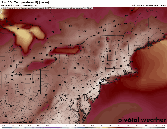
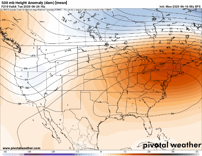
Euro has hundies much of next week on favored spots
-
Gonna be some folks that succumb to the heat in the ACATT crowd. Will become shut ins… invalids, recluse
-
This may be one of the first times that we have seen a 100°+ signal from a 50 member ensemble mean over 200 hrs out.
-
Up to .53" of rain since Saturday evening. Slowly getting there...
-
0z Euro has 104 degrees past Port Jefferson next Tuesday
-
I really wish it would just actually rain. This dreary, cold, drizzly mist just flat out sucks...
-
.10” Saturday morning/afternoon and drizzle yesterday morning up here but was finally able to sit outside yesterday afternoon.
-
Picked up 0.52” overnight for 0.60” daily total
-
We have seen a bunch of green "inch" worms the last couple weeks. At least the lake is full with all the rain we've had, would be nice to get some warmer temps, haven't had the guts to jump in yet
-

2025-2026 ENSO
PhiEaglesfan712 replied to 40/70 Benchmark's topic in Weather Forecasting and Discussion
I think it's pretty apparent that we're going to have a very quiet hurricane season in the Atlantic. Unlike last year, the Pacific is very active, already on their 4th named storm. As they say, when the Pacific is active, more than likely the Atlantic is quiet. This year is going to look more like 2013/2014 than 2010/2011/2012. -
Woke up to some rain showers, can we hold off on heavy rain one more day please? 13U champ game is tonight!
-
got down to 48 last night..
- Today
-
Not happenin, but it’ll be pretty hot some days. Looks like there’s a bit of afternoon overmixing in some of these gfs runs again.
-
picked up .28 rain this morning. total for June so far 3.52. 19.49 for the year.
-
.5” since midnight
-
00z GFS with 7 straight days 97-102 for SNE next week
-
Euro is still hitting near 24C 850s next Tue with W-WNW flow. GFS is looking similar…100° threat on both models. The 6/24 records are already vulnerable at most sites. The GFS lost that goofy summer “polar vortex” too.


