All Activity
- Past hour
-
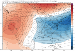
AI GFS continuing its trend of shifting the trough West
-
It's a good model.
-
So far, nothing meaningful changewise on the GFS
-
GFS is trending west a little with the western ridge BUT it's also flatter which is probably offsetting any gains in longitude
-

Possible coastal storm centered on Feb 1 2026.
78Blizzard replied to Typhoon Tip's topic in New England
Besides those two outliers to the south, there are 5 others that are far to the east, and that is obviously pulling the mean more to the east than what the rest of the members would suggest. The vast majority of the members are to the west of the mean. -
 I Don’t understand the Level of Excitement in here all week to through the storm. Yes it’s Great. But have you All Forgotten HOW many storms we’ve had in here where Everyone was Ripping 24”-36”+ with 3-4” per hour During the storm? This is a full notch below it. Everyone is close to 20. It’s Fantastic. But It’s not Boobs out in the Bahamas “Oh My God I’m losing my mind of happiness!” like Belichick on Senior Day. And You all think I’m losing my mind. Just take for instance JUST March 2019. I got just about the exact Same amount in that storm as this. EXCEPT, the Compact total was 16”, not 14” like this one, And it came as a Bomb in 1 piece. AND most of you got 10-14, and I Jackpotted with 17.25. Vs. Everyone from freaking Providence to Hartford to Blue Hill to Boston to Ipswitch in here getting 20….. And I get flipping under 18. March 2019 was a Run of the Mill Medium Level Fairly Forgettable storm of mostly 10-14, and yet it was Better in Every way for my area except for duration. Let alone talk March 2018 or many other Not totally historic events that were still better, Never Mind start talking 1996, 1997, 2005, 2013, 2015 or dare I mention the “RI Screw Job from Hell Fujiwawa 2013” that was 2 feet for everyone But RI. You guys were so starved for a big storm you’ve acted the whole 7 days like this was the Blizzard of 2005 or 2013.
 -
That is THE storm...NAM is just 12 hours faster getting it going...which I am not sure is a good thing...it opens the door to a minor snowfall v all or nothing...but it has the surface wave running out ahead of the NS upper feature such that the timing for a bigger event is probably off.
-
 I remember when Baltimore had more 20"+ snowstorms than Boston (with the disclaimer that Logan is a lousy spot and it missed many 20"+ events that hit other parts of the city). But the big ones have really accelerated and looks like this will be another one to add. And man is it well-deserved after the last 3-5 awful years. Everyone won this time.
 -
Be mindful of the fact that with the last storm the models completely underdid the western extent of the energy diving out of Canada for several days. How far west that gets when it cuts off will be a major player in how far west the coastal is
-
Calling it "Snow Sandy" is gold.
-
okay okay GFS loading, @David-LI do PBP
-
Love the Jiminy Peak stoke. Growing up, that was our Sunday spot into the evening night skiing.
-
Its only the 2nd of this winter. And the first produced a widespread half inch to 2 inches! This is the original and probably the one and only Cape storm. I identified the way out of the shit the blinds pattern and it actually worked out. https://www.weather.gov/phi/eventreview20220103 I did/still do like early Feb, so we shall see. RN it looks like places right along the coast might get nailed, subject to change ofc.
-

Possible coastal storm centered on Feb 1 2026.
cleetussnow replied to Typhoon Tip's topic in New England
Kills the pythons in the glades -

The “I bring the mojo” Jan 30-Feb 1 potential winter storm
WiseWeather replied to lilj4425's topic in Southeastern States
Lets reel this on in. . -
Careful or I'll give you the weenie ring.
-

Snow Contest January 25th-26th
WeatherGeek2025 replied to WeatherGeek2025's topic in New York City Metro
Central Park 11.5 Boston: 20.2" Hartford: 17.3" Philadelphia 9.3 Albany? Dc? -
It brings up an interesting question what is your limit as a snow weenie from one storm? I have a wind limit of about 25. Never been found of high winds, they're conducive to losing power and nothing worse than watching a snow storm in a cold dark house. I'd put my accumulation limit at 50 inches. The February 2010 blizzard which hit the west side of the Hudson particularly hard with a heavy wet snow was when I realized I had a limit. We had 35 inches from that storm in Highland Mills, with several inches on the ground before it began. Towards the end of the storm I started to find myself getting concerned whether my roof and decks would handle the weight. Other than that let it snow.
-

Possible coastal storm centered on Feb 1 2026.
ineedsnow replied to Typhoon Tip's topic in New England
way better compared to the op -
Our favorite JV model is running.
-

Possible coastal storm centered on Feb 1 2026.
Prismshine Productions replied to Typhoon Tip's topic in New England
540 line to freaking Miami and sub freezing Wind Chill in the Bahamas Sent from my SM-S166V using Tapatalk -

The “I bring the mojo” Jan 30-Feb 1 potential winter storm
ADB83 replied to lilj4425's topic in Southeastern States
ICON EPS still throws a similar amount of precip this way, just slightly less. I agree with everyone else, I think we’re all worried about missing to the south. By far the biggest threat here . -
-
Possible coastal storm centered on Feb 1 2026.
Prismshine Productions replied to Typhoon Tip's topic in New England
Precip wise but damnnnn -

January 24-26: Miracle or Mirage OBS Thread!
Snowciopathic Snow Bro replied to Jebman's topic in Mid Atlantic
We've been overdue for a while, so it finally caught up with us. I'll believe the weekend storm when I shovel it, hahaha. At least by that time I'll be in shoveling shape! Seriously, this area has to thread the atmoshperic needle perfectly to get one of the gynormous storms. That's why we only get them on average once every 7 to 10 years. Usually it's 34F and 2" of rain. 2009-10 was my personal holy grail, as I had always hoped to have 2 big storms in one season. I got that and more. Dec 2009 was really interesting because I developed shingles just before that big storm hit, and I had to literally hike my way through thigh-deep drifts to get to the local CVS to fill the prescription. Little did I know what awaited us 6 weeks later. Fun times.


