All Activity
- Past hour
-

December 2025 regional war/obs/disco thread
HoarfrostHubb replied to Torch Tiger's topic in New England
Wunderground’s Franken-model likes it
-

Central PA Fall Discussions and Obs
Blizzard of 93 replied to ChescoWx's topic in Upstate New York/Pennsylvania
The 6z Euro is looking good for Tuesday’s chance, especially back near I-81 to the west & north.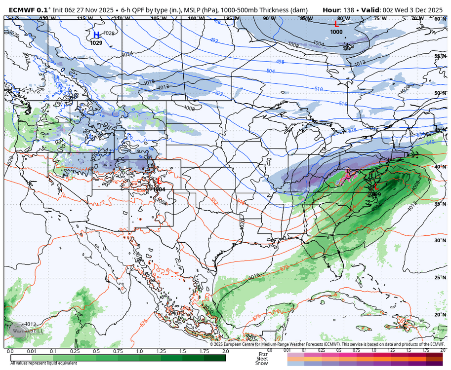

-
Temp down to 35. After yesterday this feels really cold
-
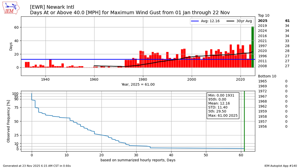
A record number of days this year for gusts over 40mph with so many lows racing through the Great Lakes.
-

2025-2026 Fall/Winter Mountain Thread
ncjoaquin replied to Buckethead's topic in Southeastern States
Happy Thanksgiving all! Definitely not a torch today. -
0" for me. Sweet. Sent from my SM-S921U using Tapatalk
-
-

December 2025 regional war/obs/disco thread
moneypitmike replied to Torch Tiger's topic in New England
LOL at Maine. -

December 2025 regional war/obs/disco thread
Damage In Tolland replied to Torch Tiger's topic in New England
Early estimates seem like a 4-8 or 5-10” type storm lollis to 12 -

December 2025 regional war/obs/disco thread
Ginx snewx replied to Torch Tiger's topic in New England
Classic setup for a SNE snowstorm.png.1dc79e2430e0aa9c114a34ae88f762af.png)
-

Nov 28-30th Post Turkey Day Wintry Potential
migratingwx replied to Chicago Storm's topic in Lakes/Ohio Valley
Here we go!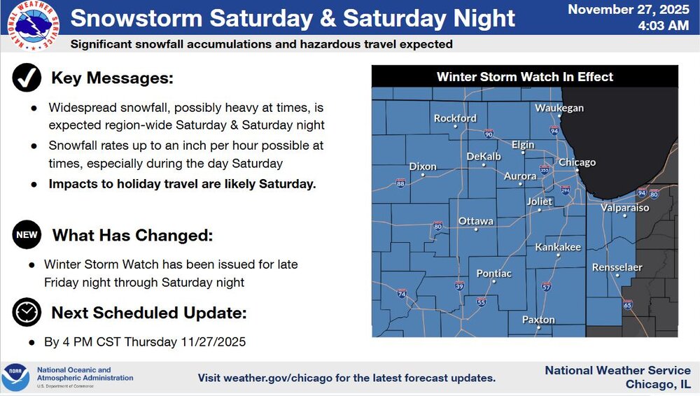
-
December 2025 regional war/obs/disco thread
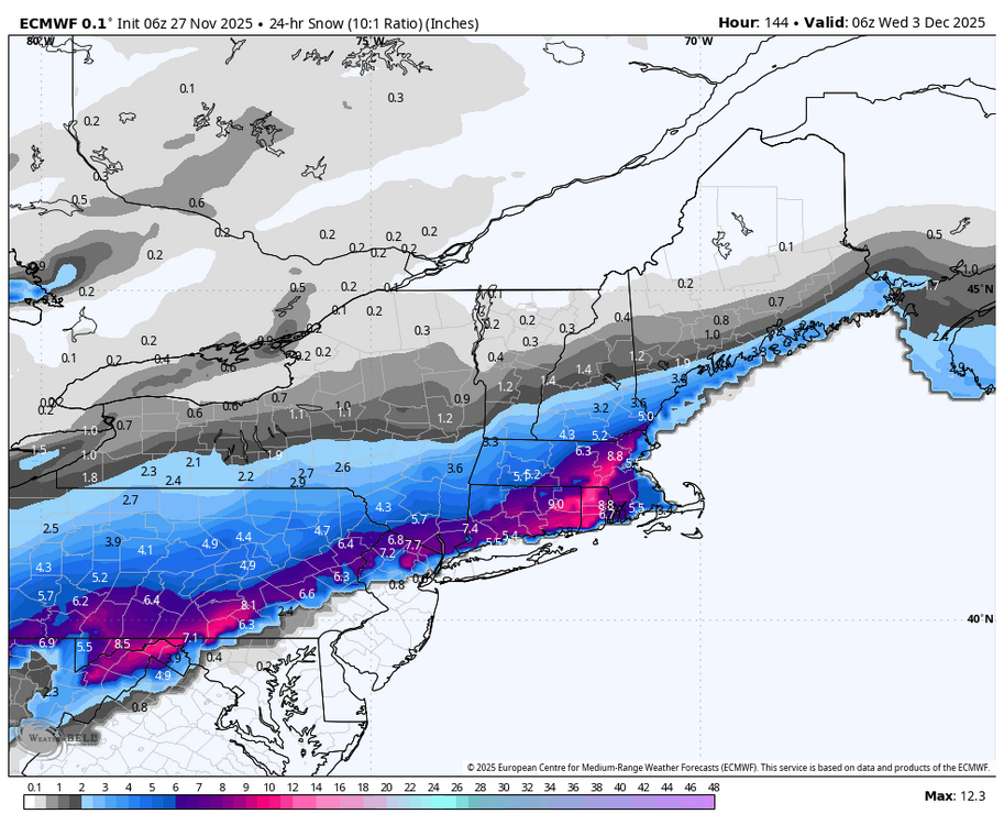
Ginx snewx replied to Torch Tiger's topic in New England
I would hit this hard. 6Z Euro with more to fall.png.8651a6e6bf2e25adf65191f7b5efe3cf.png)
-
 To you as well
 -

Nov 28-30th Post Turkey Day Wintry Potential
King James replied to Chicago Storm's topic in Lakes/Ohio Valley
Let’s see if I can get 2 feet by December 1st -
Was that 2022? 23?
-
December 2025 regional war/obs/disco thread
Ginx snewx replied to Torch Tiger's topic in New England
Let's Jerry antecedent days all month! -

November 2025 general discussions and probable topic derailings ...
CoastalWx replied to Typhoon Tip's topic in New England
Happy Thanksgiving! -
Man here’s hoping. Can we just get one early season for once. I don’t remember the last big early December snow up this way.
-
December 2025 regional war/obs/disco thread
Baroclinic Zone replied to Torch Tiger's topic in New England
We baste today. See what transpires on model runs. Barring anything major, it looks like a good start to MET winter for some coming. -

Nov 28-30th Post Turkey Day Wintry Potential
Chambana replied to Chicago Storm's topic in Lakes/Ohio Valley
Probably gonna lose a few inches due to melting and compacting here, still a fast start to winter, none the less! Love to see it -
You were at the last one??Dec 22

-
December 2025 regional war/obs/disco thread
Baroclinic Zone replied to Torch Tiger's topic in New England
Yeah, lead wave plays a pivotal role in sensible outcome. Pointed that out yesterday. Sort of torn on stronger trailing wave as that would likely introduce more warm sit intrusion with retreating high. -
Dang, I didn't even look the weenie that I am! You're right!
.thumb.png.f286bba9fd8ce4327c6695bef9ff5948.png)
-
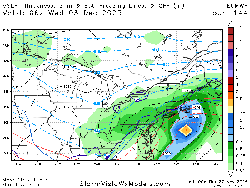
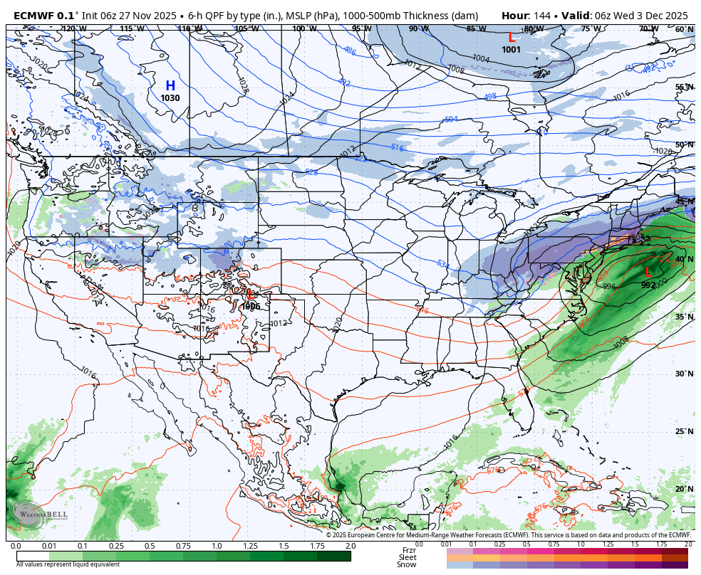
Still looks like could be little more after 144 too.
-

Nov 28-30th Post Turkey Day Wintry Potential
Jackstraw replied to Chicago Storm's topic in Lakes/Ohio Valley
This things gonna cut right over me. Will literally be 5 mile shift in track that we could get warning criteria snow or 3in of slush. KIND rather bullish on warning criteria just to my west with the question mark right on top here as usual lol. White knuckle weekend ahead, pun intended. Go big or go home, I'll call 6in here. lol


.png.3248c56e788d5ab44acf35a4e9ec4453.png)