All Activity
- Past hour
-
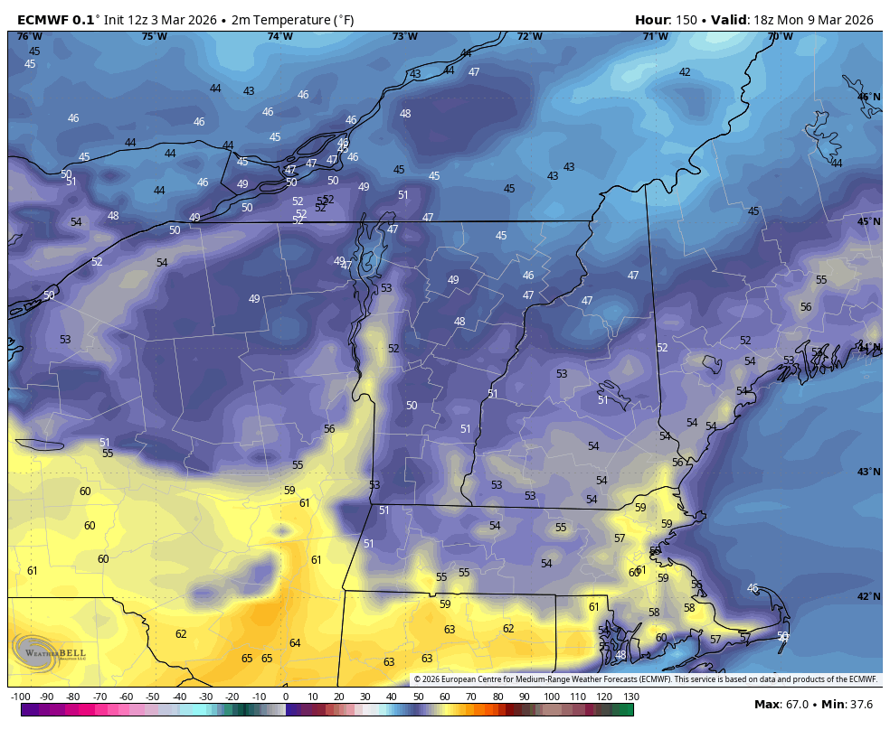
I found those sharp gradients interesting too… like the model couldn’t figure out if it’s fully mixing or not from one location to the next. Figured snowpack was impacting those 2-m outputs.
-
The same red sky and sun with billboard silhouette that inspired the beginning of "Tonight" in the original West Side Story. Must have been HHH the day of the rumble.
-
12/5: 1.5" 12/14: 1" 1/1: 0.3" 1/17: 0.1" 1/25: 9.5" (5.5 snow/4 sleet est.) 2/6: 0.3" 2/22: 3.3" 3/2: 2.0" Total: 18.0" Surprising to me that I beat last year's 16.9" IMBY. Stuck around forever this year, but felt like less.
-

E PA/NJ/DE Spring 2026 Obs/Discussion
Physicsteve replied to PhiEaglesfan712's topic in Philadelphia Region
The second of those weeks could be our last trackable window, say 3/15-20. eta: fantasy land caveats apply -
May get .50 of ice . Let’s flip over quickly now . Snow is pointless today with 70’s all next week . Temp dropping down to 25.8
-
It's as though it is also estimating the retreat of the snow pack across those days... interesting. It may actually look something like that, as reflective in the 2-m temperature shrinking cold
-
29° with huge snowflakes again.
-
probably slightly over 32 then
-
1.5” snow/ip mix now.
-
Many places in N Queens/Nassau are reporting 32, had friends check though and they told me they are not seeing any freezing on the trees or any surfaces
-
The east wins again lol
-
Got pretty heavy for a bit and picked up a very quick inch or so on the colder parts of my driveway and cartops, etc. Eventually started to stick on the road too, was just out, roads are not great.
-
27/24 and heavier echoes coming in almost a mixed bag back and forth to snow at times here less than a half inch so far meh
-
if this band to the west comes in as snow. it will pound for a bit
-
That SW flow downslope off the Adirondacks can really torch that pocket this time of year.
-
3/2: .5 Total: 24.6
-
Definitely missed the band so will likely end up with maybe half inch before it flips . So close but it’s missing south
-
Hit 47 diurnal range today… 39/-8 but clouds now should slow it. Doubt we get the rare 50 degree swing.
-
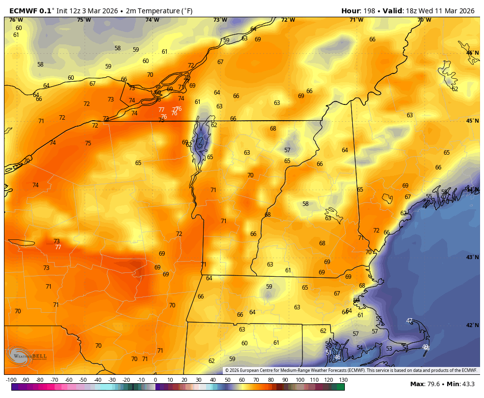
Damn upper 70s in Canada
-
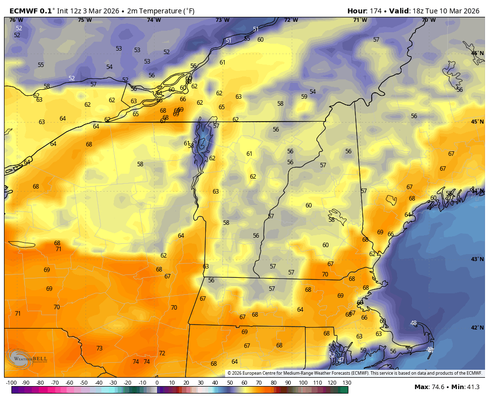
12z EURO showing some nape tanning next week… Monday… Tuesday… Wednesday…


-
Looks like a 4-5 day window to get warm Sunday through Wednesday or Thursday.. 55-60 likely.. 65-75 if we can get a clear warm sector..
-
Warmest temp of 2026 in March this year?
-
The one time I need DCA to put up a pitiful early March daytime measurement..
-

Outta gas and Outta Time: Early March Winter Storm finale
Chris78 replied to Ji's topic in Mid Atlantic
Yeap. Just got to hope for the best and take our chances -
Clouds finally coming in, preventing a possible 50+ diurnal range, as the morning low of -12 rose to 34-35 before noon. BML hit the 50s range, with 39/-14.