All Activity
- Past hour
-

November 2025 general discussions and probable topic derailings ...
CoastalWx replied to Typhoon Tip's topic in New England
Good news for you. More rain. -

November 2025 general discussions and probable topic derailings ...
ineedsnow replied to Typhoon Tip's topic in New England
still close I'm sure we see flakes here -
Side note, like seeing the colling off the coast of China and Indonesia.
-
Not sure the season is salvageable. Daniels will be out rest of the season. Mariota isn’t going to carry us to the playoffs. Just put a fork in it, we done.
-
-

2025-2026 Fall/Winter Mountain Thread
Maggie Valley Steve replied to Buckethead's topic in Southeastern States
30 with heavy frost this morning. -
I see that comes with an optional shield, which I assume you also purchased. I wish mine came with a shield that can be swapped out for a better one.
-
Wet morning here in the lowlands. We must of had drizzle overnight.
-

November 2025 general discussions and probable topic derailings ...
kdxken replied to Typhoon Tip's topic in New England
So much for the torch nonsense. -

November 2025 general discussions and probable topic derailings ...
Brewbeer replied to Typhoon Tip's topic in New England
Light frost here, 32/32, yesterday morning was colder. -
serious doldrums, remain convinced will snap back to wild stuff eventually
-
b2b gfs runs hinting at wintery mix potential this weekend, probably a mirage but it's about that time of year
-

November 2025 general discussions and probable topic derailings ...
alex replied to Typhoon Tip's topic in New England
While not as cold as it has been, today is the first time I’ve noticed wetlands and small ponds are completely covered in ice. -
November 2025 general discussions and probable topic derailings ...
CoastalWx replied to Typhoon Tip's topic in New England
Yep Fall is right around the corner. -
 Made it down to 26.1°. Not as cold as Oct 10th, but still pretty chilly. I suppose winter is on its way.
 -
Many have been posting daily about how much they miss you when you’re not here to light our darkness.
-
November 2025 general discussions and probable topic derailings ...
CoastalWx replied to Typhoon Tip's topic in New England
Congrats NNE -
November 2025 general discussions and probable topic derailings ...
alex replied to Typhoon Tip's topic in New England
Stayed cloudy a good chunk of the night so only made it down to 24F. Nice to see the sun this morning! -
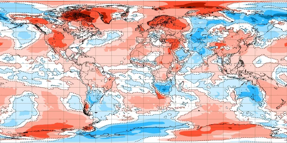
The Northeast Pacific continues to cool, the “blob” area has cooled over -1.25C since September 1st. While these SSTs are not driving the pattern, it’s indicative of a longwave pattern that favors cooling in that area. If we get to 11/30 with no sign of this trend completely reversing, it’s going to become very difficult for people to continuing using years that saw SST patterns with a “warm blob”. To clarify, I’m only speaking of the people who are using SST analogs with warm blobs, not other factors (QBO, solar, PDO, AMO, etc.) to justify certain analogs
-
Disaster injury, disaster defense, disaster game. This team is 180° opposite last year. Can only blame injuries so much. Other teams have them and don’t look anywhere as awful. If the D coordinator isn’t fired this week they just don’t care about saving the season
-
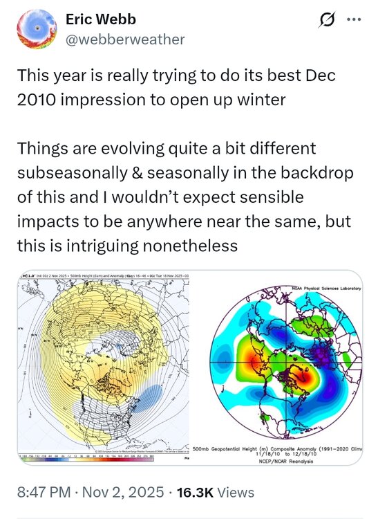
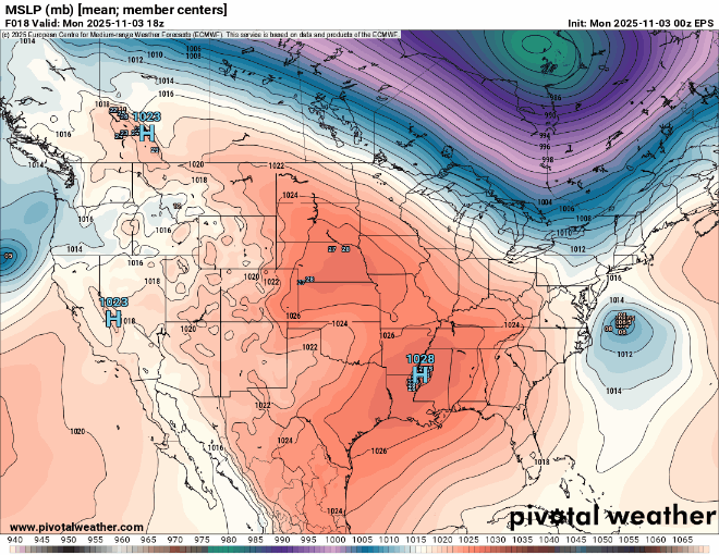
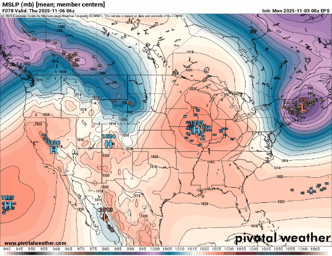
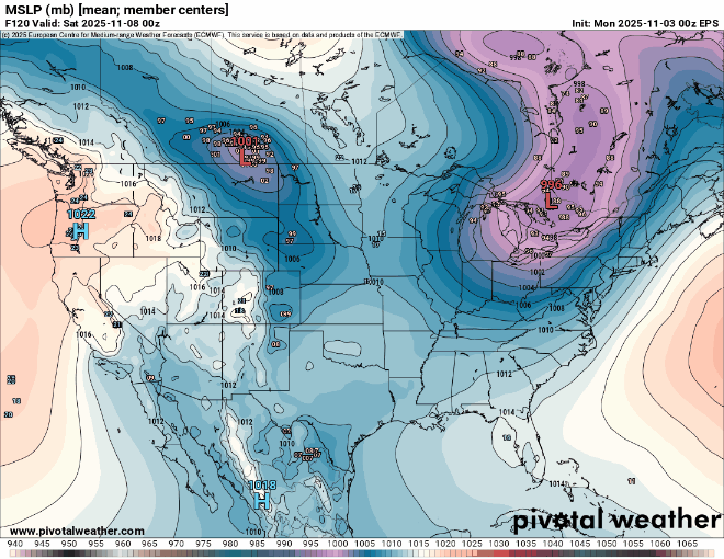
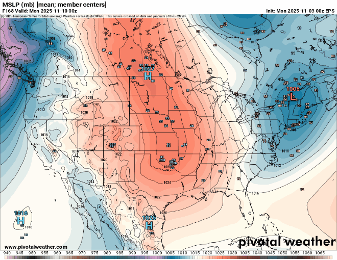
Very fast Northern Stream pattern continues into November. A storm system cutting through or north of the Great Lakes every few days. Tough to get much in the way of coastal storm development as we have seen in recent years. So we get warm-ups ahead of the lows and cool-downs behind. But no significant cold for this time of year due to such a strong Pacific influence. North America is very warm for this time of year and all the real cold is over in Siberia. This contrast between the record SSTs in the North Pacific drives the fast Pacific Jet. November 3 to 10 EPS forecast
-
The IOD is peaking right now. It’s at -1.94 through 11/2 and expected to peak by 11/10. With the ongoing cooling in the WIO and warming in the EIO, I expect it to bottom out on the next weekly update at or slightly below -2.
-
 Ineedsnows snower disappeared next week
 -
They led the way on Helloween. Even tonight into tomorrow looks like 40-45 mph gusts
-

November 2025 general discussions and probable topic derailings ...
Modfan2 replied to Typhoon Tip's topic in New England
Yup, down to 29F down here before the clouds rolled in


