All Activity
- Past hour
-
We’re weenies-extremes are where it’s at-bring it!
-

Central PA Summer 2026 Discussion/Obs Thread
Jns2183 replied to Voyager's topic in Upstate New York/Pennsylvania
All I got to today was 91, dp 68, hi 95 Sent from my SM-S731U using Tapatalk -
 I've wanted to use torrid, but it implies dry or parched, so that matches desert-type heat better.
 -
Idiot AI. 1.3 mi from the summit as if that is a fair comparison when dealing w/ sharp elevation. I've played w/ AI query for historical wx, and it messes up a lot. Conflates events and overlooks obvious details that make all the difference.
-
June finished at 71.4 here. Last June was 71.1. Pretty close
-

2026-2027 Super El Nino
GaWx replied to Stormchaserchuck1's topic in Weather Forecasting and Discussion
It’s official. The DMI daily mean Arctic temp N of 80N, with the help of a +AO, never made it up to freezing in June! The previous latest to first get to freezing was June 20th, set in 2013. The June 30th # was -0.25C. Let’s see whether it gets above 0C on July 1st: @Stormchaserchuck1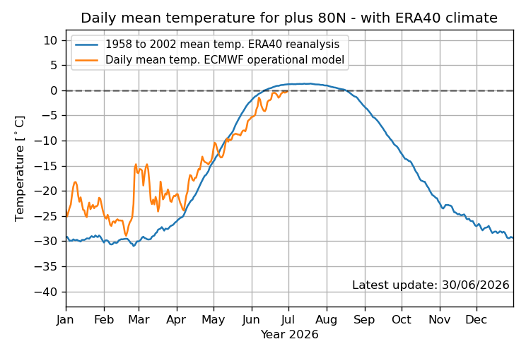
-
.thumb.gif.f92b16c631a1d15d405ed77b33f0710d.gif) on the 0z gfs, you can trace the h7 vorticity back to the four corners area. Good trajectory to get an EML or remnant EML in here
on the 0z gfs, you can trace the h7 vorticity back to the four corners area. Good trajectory to get an EML or remnant EML in here -
I was just referring to how much you defend the O's. Personally, I think Albernez was a huge mistake and, although I'm sure there are many that will disagree with me on this, but I'd be selling big time this year. Gunnar included, unless he is willing to accept a lower contract until he delivers.
-
Saturday looking better for storms. Remnant EML? and should be some nice dcape if heating doesn't get mucked up by debris
-
Yeah I got a feeling this past winter was a Unicorn . Hope it's not too bad for severe n the deep south
-
In North Dakota we regularly saw -12 to -18F inversions between 0.5 and 9m. Between +2 and +6F during the daytime depending on soil dryness and vegetation. AASC Standard is between 1.5m and 2m. WMO is 2m. I prefer the 1.5m personally, but MD Mesonet follows the 2m.
-

2026-2027 Super El Nino
Stormchaserchuck1 replied to Stormchaserchuck1's topic in Weather Forecasting and Discussion
June SOI finished with the lowest monthly reading since early 2016. Healthy El Nino ongoing Still not seeing that North Pacific response, however Pretty much the opposite pattern coming up ENSEMBLE LOOP -
No discernible impact from slightly less sun angle July is the warmest month climatologically even though the days are getting shorter. This has to do w/ the Earth's heat balance, and the lag that exists in the atmosphere and ocean. 1 month lag for the atmosphere and 3 months lag for the oceans as to max avg temps.
-

Fireworks Heat Contest W 7/1 - S 7/4 for Five MA Airports
southmdwatcher replied to nw baltimore wx's topic in Mid Atlantic
Just entered -
Fireworks Heat Contest W 7/1 - S 7/4 for Five MA Airports
southmdwatcher replied to nw baltimore wx's topic in Mid Atlantic
DCA 100, 103, 105, 100 BWI 100, 104, 106, 99 IAD 99, 103, 105, 98 SBY 97, 102, 105, 103 RIC 100, 104, 105, 101 Total sum rain 1.26 -

Fireworks Heat Contest W 7/1 - S 7/4 for Five MA Airports
nw baltimore wx replied to nw baltimore wx's topic in Mid Atlantic
Thanks for the entries. I double-checked the data, but I know me, so I'm sure there's a mistake somewhere. Check your entries and let me know if I screwed up.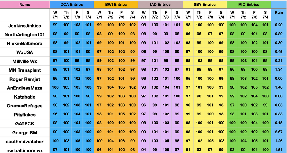
- Today
-
It would be nice to actually get some afternoon and evening storms the next few days, though I’m not sure it’s gonna happen atleast where I am
-
I'm actually not 100% sure what you're referring to, lol
-
 It will be a day of lots of 97-99 readings.
 -
 Turned on AC for first time this evening. Getting soupy out there...70/69. Let's get that MCS later...trajectory looks good but expecting it to fizzle approaching the coast.
 -
 BOX Point & Click is 104 now for the western part of Enfield on Thursday. I'lm thinking a few less.
 -
Yeah could be feast or famine. Hopefully a couple of big boys. Could have like a +4 month but if you somehow sneak in a MECS or HECS it feels pretty good.
-

2026-2027 Super El Nino
PhiEaglesfan712 replied to Stormchaserchuck1's topic in Weather Forecasting and Discussion
If the monthlies still say cold when get to the fall, then that's the time to start paying attention. I know strong and super el ninos usually mean warm winters, but if the monthlies are still showing a cold signal for winter in the fall, then you know something is up. -
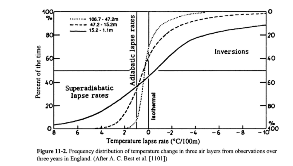
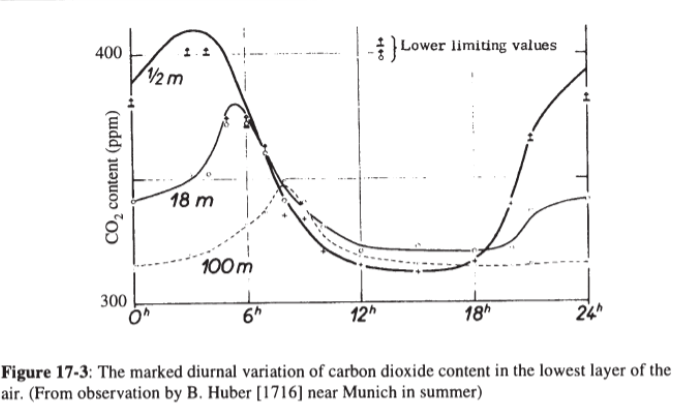
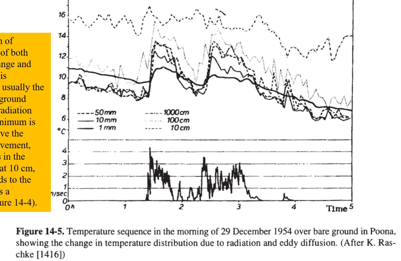
My original post was more concerned with the microclimatology that takes place near the ground during strong surface heating or radiative cooling. Agree that the function and possible inaccuracy of thermometers is important in this discussion, but the variation near the ground is amazing regardless. Below is a page right out of my textbook from last semester! Look at the frequency of super adiabatic lapse rates or inversion near the ground! Only around 10% of the time in the lowest 15 meters of the atmosphere are the lapse rates "normal" in our human range. The difference in air temperature between the street and the rooftop of a several story building could be several degrees C. Therefore, I think its fair to question how representative our 2m standard is. Additionally, this problem is exacerbated at nighttime when temperature inversions develop without strong eddy diffusion to disrupt the inversion sublayer. The graph below shows how much temperature variations exists right beneath our noses! Within the lowest 1m of the atmosphere we can see a temperature variation of 3 degrees Celsius. Then the difference 1m to 10m is another 4 degrees Celsius under calm conditions. These discrepancies matter! The lowest segment of the boundary layer that humans inhabit are defined by rapid changes with height. Take CO2 PPM as an example of the practical effect of this microclimate, a sensor at 2m is a great data point, but does it really represent the CO2 available to crops growing on fields? It is important to remember that our standards are just that: standards. They are abstractions that always leave some part of reality behind. When making decisions about heat, frost, drought, or other atmospheric events the local microclimate must be kept in mind. As a closing example, take a pool deck in the summer. Say the standard 2m temperature is a heat advisory on its own. The pool deck may instead reach extreme heat criteria as the latent heat flux of the pool water increases humidity and hot concrete deck makes the effective temperature to children, who are only a meter tall, significantly hotter than anticipated. The point of this and my previous post wasn't to say that the 2m standardized station isn't useful, nor was it to imply that the science behind our tools is not important. It was to instead clarify that these microclimates near the ground are extremely important in their own right and must be considered for effective decision making.