All Activity
- Past hour
-

Major Hurricane Melissa - 892mb - 185mph at landfall
WolfStock1 replied to GaWx's topic in Tropical Headquarters
Here's the thing - I've driven through Chimney Rock, which was probably the worst-hit place, just a few months ago. Roughly half the downtown was wiped out. But generally that's about it; and it's a quite-small downtown actually. I have relatives that live right there in Lake Lure, and they - along with about 95% of the area - were relatively unaffected, aside from lost power, some downed trees, and some road washouts. The vast majority of structures were generally unaffected. You see the spectacular devastation of the areas hardest hit and assume that's the majority of places, but it's not; it's media selection bias. Contrast with the eye wall of a hurricane - of this force - which will wipe out almost everything; leaving almost no structure at least undamaged, and completely destroying a high percentage. Part of the reason I say that is due to the poverty of Jamaica - they just don't have the hurricane wind standards that the US does. (Just to reiterate - not trying to understate the fact that there will be massive rain-flood damage; I'm just asserting that I think the wind damage will likely be worse, along with the storm surge flooding.) -

Major Hurricane Melissa - 892mb - 185mph at landfall
WxWatcher007 replied to GaWx's topic in Tropical Headquarters
Ah, I was referring to radar for low level structure. It’s really hard getting regional radars. -

Major Hurricane Melissa - 892mb - 185mph at landfall
canderson replied to GaWx's topic in Tropical Headquarters
That’s due to the forming nor’easter -
 ESE flow ahead of a low tracking inland means lots of upslope for E PA/upstate NY and showery weather for the city/coast. Some places east of the low would get lucky with banding but by far the best would be well inland. Looking like a couple/few day nasty period without much drought help here. Thankfully we had the storm mid month to help a little.
 -
Yeah, a chilly day today with mid-50s, a breeze, and overcast.
-
Central PA Fall Discussions and Obs
canderson replied to ChescoWx's topic in Upstate New York/Pennsylvania
He’s quite east of me so I can see it. -

Major Hurricane Melissa - 892mb - 185mph at landfall
Brian5671 replied to GaWx's topic in Tropical Headquarters
Not related that's from a separate storm -

Major Hurricane Melissa - 892mb - 185mph at landfall
MonumentalNole replied to GaWx's topic in Tropical Headquarters
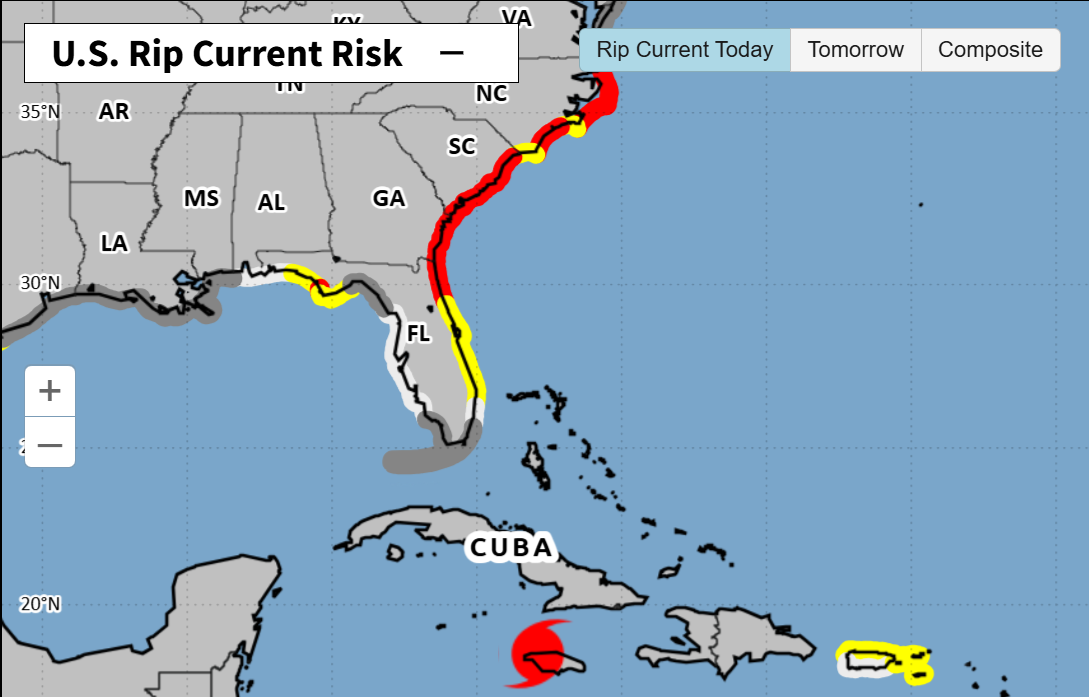
Is Melissa causing the current rip tide off the SE US coast from the other side of Cuba? Or is that due to other environmental factors and just a coincidence?
-

Major Hurricane Melissa - 892mb - 185mph at landfall
Torch Tiger replied to GaWx's topic in Tropical Headquarters
portion of a roof went off in that Reuters live feed! -
post what you want about what you want when the weather is slow and there's nothing to track, everyone else does
-

Major Hurricane Melissa - 892mb - 185mph at landfall
ineedsnow replied to GaWx's topic in Tropical Headquarters
Going to be interesting to see what she does in a few hours once back over the water -

Major Hurricane Melissa - 892mb - 185mph at landfall
Interstate replied to GaWx's topic in Tropical Headquarters
https://weather.cod.edu/satrad/?parms=subregional-W_Caribbean-15-48-1-100-1&checked=map&colorbar=undefined -
Thanks for making some of us feel extra old. (Are you sure he was your GREAT Grandfather?) Beautiful shot which probably looked the same in 1979. Very cool. BTW, had a major (MECS) snowfall that year.
-
Major Hurricane Melissa - 892mb - 185mph at landfall
WxWatcher007 replied to GaWx's topic in Tropical Headquarters
Can you post? I can’t get the regional radars to work. -
Major Hurricane Melissa - 892mb - 185mph at landfall
WxWatcher007 replied to GaWx's topic in Tropical Headquarters
C4 now -
Major Hurricane Melissa - 892mb - 185mph at landfall
Interstate replied to GaWx's topic in Tropical Headquarters
Looks pretty messy on the latest radar image -

E PA/NJ/DE Autumn 2025 Obs/Discussion
Hurricane Agnes replied to PhiEaglesfan712's topic in Philadelphia Region
Winds ended up at 185 mph sustained at landfall with some gusts in the mountains upwards of 225 mph! Ryan Hall has been streaming and showing some of the area cameras and where those cameras are, structures seem to be hanging in there. -

Major Hurricane Melissa - 892mb - 185mph at landfall
RaleighNC replied to GaWx's topic in Tropical Headquarters
There is no other place to build there, and Helene's flood was orders of magnitude bigger than any prior flood, so it reached areas that had been assumed to be safe. Much like what is about to happen to Jamaica. And landslides happen where you never think a flood will happen. To say Helene didnt have any "wiped off the map" damage as one poster said, is just wrong. Ask Chimney Rock and Bat Cave and Minneapolis and any number of other communities. When the mountainside comes down, everything is gone. I pray for these poor people in the way of this one. -
Major Hurricane Melissa - 892mb - 185mph at landfall
WxWatcher007 replied to GaWx's topic in Tropical Headquarters
Looks like the center is near the coast now, so we’re going to find out soon just how intact that core still is. -
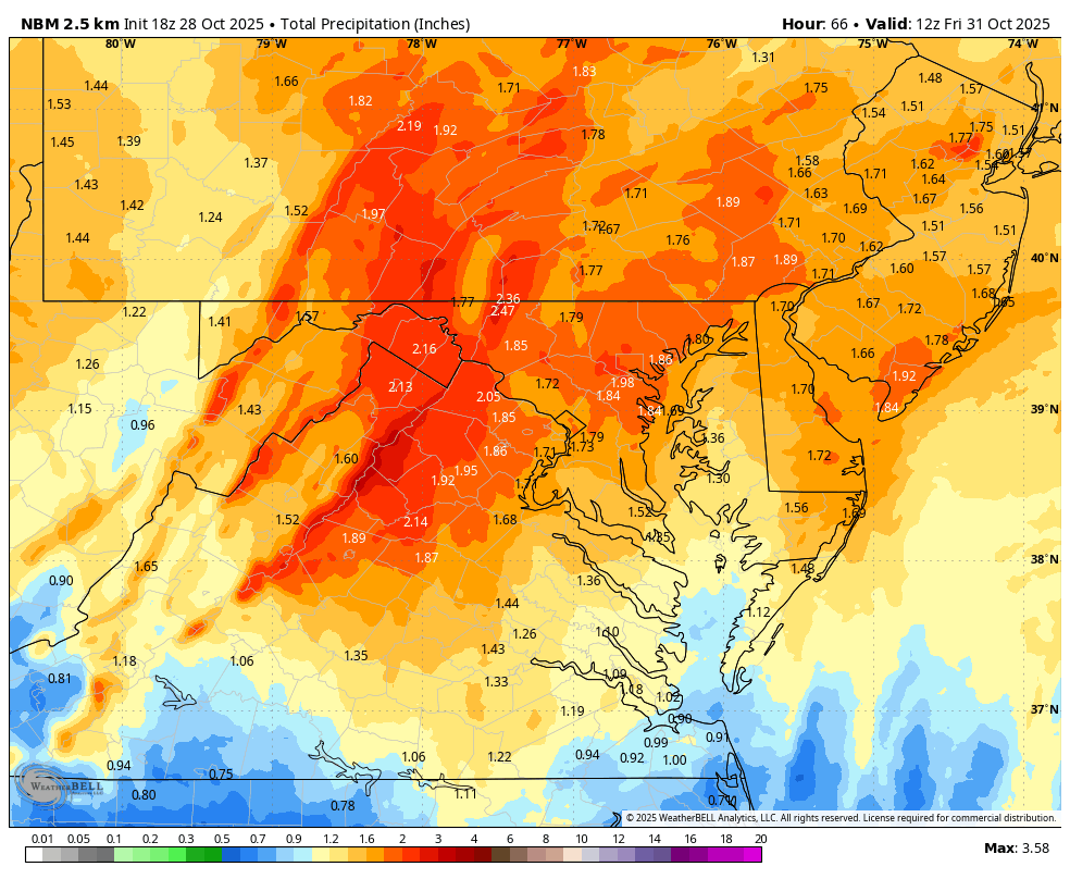
WB 18Z NBM

-
Zzzzzz nothing going on at all locally on the horizon
-

Spooky Season (October Disco Thread)
Damage In Tolland replied to Prismshine Productions's topic in New England
Damaging winds Helloween night -

Central PA Fall Discussions and Obs
Itstrainingtime replied to ChescoWx's topic in Upstate New York/Pennsylvania
Here's the snippet: In the wake of the storm system, winds will turn westerly Thursday night and intensify on Friday. The tight pressure gradient, or difference in pressure, between the storm system and an area of high pressure over the Southern States will be the culprit for some "spookily high" wind gusts of 45-50 mph on Halloween. Sustained winds should be on the order of 20-30 mph. -
Central PA Fall Discussions and Obs
canderson replied to ChescoWx's topic in Upstate New York/Pennsylvania
Wow. CTP seems to think in the 30s but today did mention wind advisories possible. -

Major Hurricane Melissa - 892mb - 185mph at landfall
HKY_WX replied to GaWx's topic in Tropical Headquarters
It will be interesting to see if the ocean starts creeping up on that cam as the winds switch north.