All Activity
- Past hour
-
My point is that any winter month when some portion the coldest departures in the Northern Hemisphere are found in the CONUS is becoming less frequent. Plus when you add a less intense cold pool like last January centering in the U.S. the results aren’t as extensive or intense as past instances. The cold pool departures last January were much less impressive than the last time the coldest departures were in the CONUS like February 2021 and February 2015. Getting a replica of 2015 has several challenges that I can see. First, the planet has had two tremendous baseline jumps in background temperature during 2015 into 2016 and an even greater jump the last 2-3 years. So this naturally weakens the cold pool. Second, the more extensive warming of the WPAC has been associated with a faster Northern Stream of the Pacific Jet. The faster jet keeps sending pieces of energy into the NEPAC blocking causing it to weaken. So we haven’t able to reach the blocking levels there we saw in 2013-2014 and 2014-2015. Third, getting a weak Modoki El Niño like February 2015 has been a challenge with the WPAC warm pool expansion. So the attempts in 18-19 and 19-20 didn’t work out.
-
-
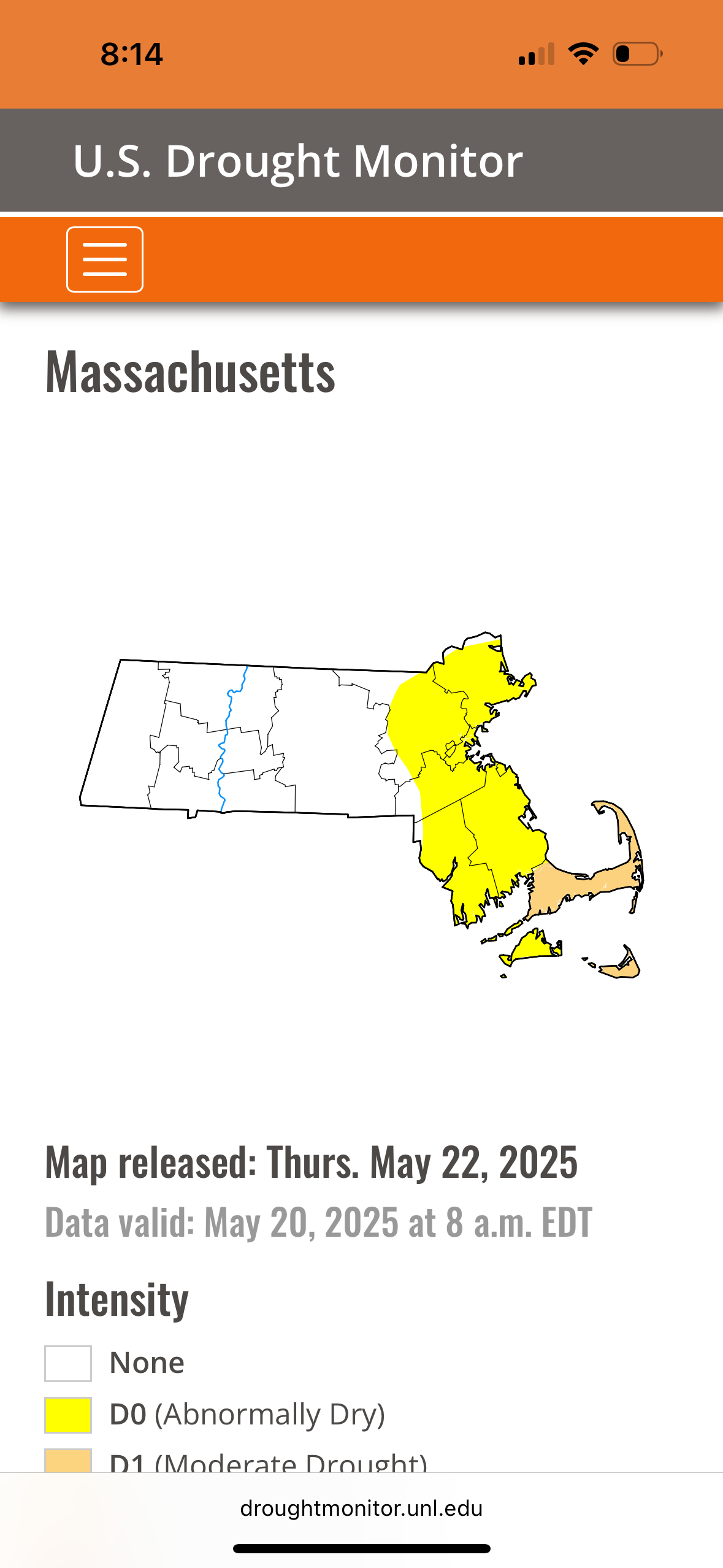
1.23" for the event. My garden is swamped but doing fine. Justin Berk is still hyping the drought on Facebook. The comments were funny. I think we're safe from running out of water. Edit: I see blue sky to the west!
-
Millersville high yesterday was 56 breaking the low max temperature record by 4 degrees.
-

Central PA Spring 2025
Mount Joy Snowman replied to canderson's topic in Upstate New York/Pennsylvania
Another low of 49 and .52” of glorious soaking all-day rainfall, for an event total of 1.09”. -
50 / 48 misty / light rain and drizzle. Hour 60 of what should be 96 hours of clouds / mostly cloudy conditions, but this could extend into Sunday approaching 100 hours. Light showers rain becoming isolated mostly cloudy although there could be some breaks in the clouds stuck near 60. Tomorrow the ULL is over the the northeast and clouds lingering - a bit warmer / drier low - mid 60s. Sunday piece of energy over the GL dives south and could trigger some scattered showers and additional cloud cover - mainly dry / warmer near 70. Monday looks to break the streak fully with partly cloudy skies and temps neareer to normal low - mid 70s. Beyond there the trough remains into the Northeast with the month closing out near normal / perhaps a warm day or day / half 29-30 or 30-31. Still lingering trough and tendency for low cutting off from the trough before the warmth in heat goes north and east by the end of the first week of next month in the way beyond: 5/21 - 5/25 : Much cooler - cloudy wet 5/26 - Memorial day slavaged 70s and dry - partly - sunny 5/27 - 5/29 : Near normal - southern system may bring light rain 5/30 - 5/31: could end with a brief warmup Way beyond : warmer into the the 6/5 - beyond period (perhaps much warmer and hotter)
-
4.16
-

2025-2026 ENSO
40/70 Benchmark replied to 40/70 Benchmark's topic in Weather Forecasting and Discussion
I don't think anyone entirely understands the factors that determine how impressive the cold source becomes for a given season...while we can be sure that the trend is for it to become less impressive, its not a perfectly linear progression, so any given year moving forward may have a more impressive reservoir to tap.....though clearly the odds diminsh with time. -
Dreading putting the dock into the lake this weekend. Looking like upper 40's water temperature. Painful.
-

2025-2026 ENSO
PhiEaglesfan712 replied to 40/70 Benchmark's topic in Weather Forecasting and Discussion
What's impressive about the 2014 and 2015 cold outbreaks is that they didn't really get going until after the new year, and they went on for 2-3 months, not really letting up until the end of March. -
Kind of a fail for CNE, but temps always looked meh despite the weenie ptype maps.
-
2025-2026 ENSO
40/70 Benchmark replied to 40/70 Benchmark's topic in Weather Forecasting and Discussion
Okay....so the earth is warming. Thanks for the striking revelation. My point is that while a relica Feb 2015 pattern wouldn't be as cold as it was then, it would still be much colder than this past January. I get the impression that you think that it would be similar to this past January and I have to disagree. The PNA (west-biased) and WPO were ideal for cold delivery to the NE US that season....last year they were not. -
We have to remember that next time models are battling east/west-the east solution tends to win out
-
I'd rather have a better view of Uranus...
-
The patterns we get are the function of the warmer temperatures and higher overall 500 mb heights. So the ridging potion at 500mb occupies more real estate than the troughs. Smaller troughs or cold pools have less overall cold. The Northern Hemisphere cold pool was near the lowest on record this past winter. This is why even though the coldest temperatures on the planet in January were located in the CONUS, amount of cold was so limited that the monthly cold ranking for the CONUS was only the 33rd coldest January. It’s also why Canada was so warm with a record low sea ice on Hudson Bay. The cold into the Northeast was very limited relative to other times the coldest temperatures in the Northern Hemisphere were in the CONUS.
-
40/39°F, 0.74", That's more then enough.
-
1.81” final. Let’s get the warmup started !
-
37.4F RN with MAYngled flakes mixed in and breezy. 1.12" since yesterday. Even the wild turkeys look angry this am
-
2025-2026 ENSO
40/70 Benchmark replied to 40/70 Benchmark's topic in Weather Forecasting and Discussion
That is precisely what I have been saying....the persistent +WPO is a byproduct of the west Pac heatwave. -
0.82". 40.3F. Let's put this bs behind us and get going with summer Sent from my SM-S921U using Tapatalk
-
2025-2026 ENSO
40/70 Benchmark replied to 40/70 Benchmark's topic in Weather Forecasting and Discussion
I don't understand what you are disagreeing with....if getting cold into the northeast is becoming more difficult, but admittedly not impossible, then how on earth do you contest the notion that the pattern has has some influence independent of the background warming?? Makes zero sense. -
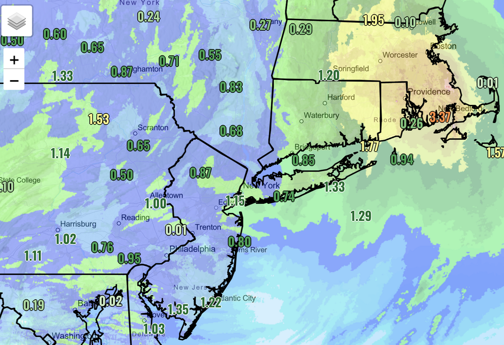
If this was winter it would have been a heartbreaker, but at least we still got something. This was a SNE special: Those oranges are 3 to 5 inches of rain.
-
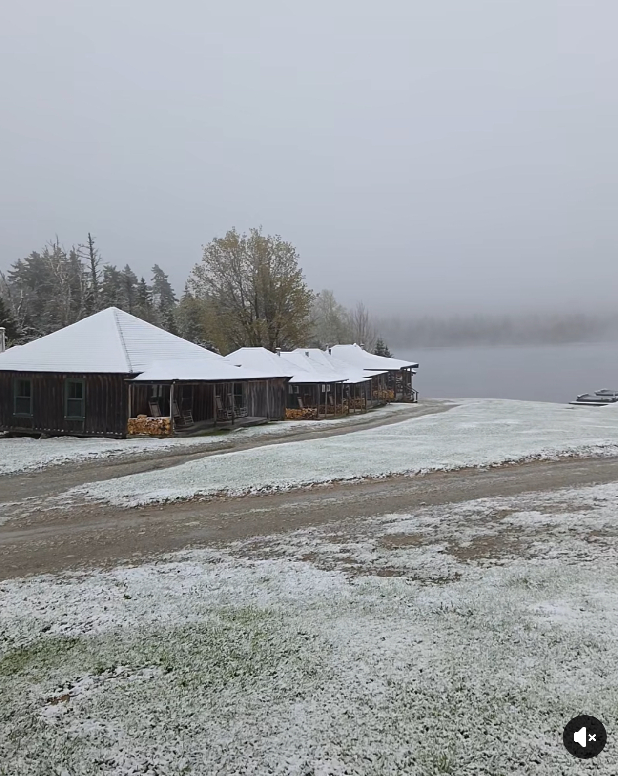
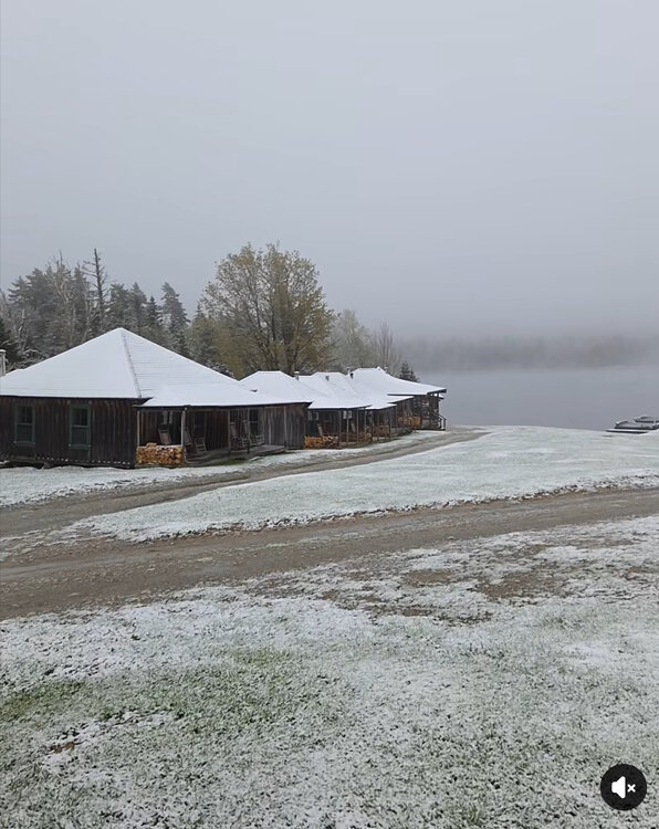
Tim Pond Camps in Eustis
-
Oh he looks like something alright
-
Has anyone seen any snow pics this morning?