All Activity
- Past hour
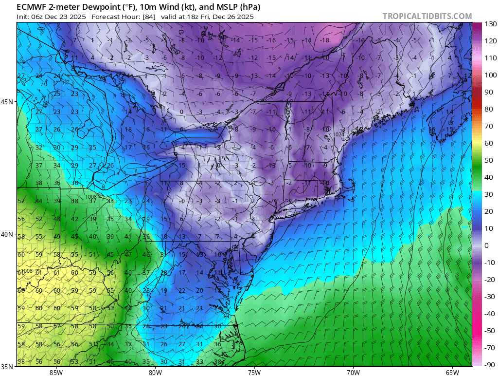
-
Crazy dewpoint gradient from 60° in WVA to below 0° here ahead of the storm on the Euro.

-

December 2025 regional war/obs/disco thread
WinterWolf replied to Torch Tiger's topic in New England
Nahh…this will do the same in time. We’ll get something to happen too. But we back to it. -

December 2025 regional war/obs/disco thread
TauntonBlizzard2013 replied to Torch Tiger's topic in New England
Yeah, looks okay there, but like I said, large majority of the area, not great. Glad SW CT can score on another event -
 I am beyond happy with the amount of snow we have here in New City Rockland County as I expected an inch maybe 2 and this event is definitely doing much better than it was advertised -----Merry Christmas everyone THIS IS GREAT !
 -
Blocking looks really strong. GFS might be closer than you think
-

E PA/NJ/DE Winter 2025-26 Obs/Discussion
LVblizzard replied to LVblizzard's topic in Philadelphia Region
Just under an inch in Allentown. Nice ground whitener. Now on to Friday! -

White Christmas Miracle? December 23-24th
tamarack replied to Baroclinic Zone's topic in New England
Back in the stone age (50s-60s) NNJ schools would schedule a few "snow days" to avoid early summer classes. (No schools had AC then.) I think only 60-61 required the extended days, as we lost 6 days to snow. Fortunately, the Feb 3-4 bomb was Fri-Sat. If mid-week it would've closed 3 days instead of one. I'm sure that Fort Kent has been lawyered away from the 70s-80s when our 9.7 years there included only 1.5 days of closes, all in 1984. -

December 2025 regional war/obs/disco thread
The 4 Seasons replied to Torch Tiger's topic in New England
I didn't say anything about 95-96, i said late 90s specifically 96-99 -
It's pretty good for CT, esp SW half....not good for E MA.
-

December 2025 Short/Medium Range Forecast Thread
Carvers Gap replied to John1122's topic in Tennessee Valley
The 12z suite looks reasonably consistent w/ the exception of the 12z GFS which for whatever reason sometimes completely loses the NAO on random runs. The 12z AIGFS looks about right. So, we are just gonna sub out the 12z GFS and grab the sixth guy off the bench. -
Even the 80s were better here. Once in a blue moon something happened.
-
way too early for that...still could miss with the S trends on several models
-

E PA/NJ/DE Winter 2025-26 Obs/Discussion
KamuSnow replied to LVblizzard's topic in Philadelphia Region
It was a treat! Even the cat was running around in it, skidding on the driveway, lol. -
December 2025 regional war/obs/disco thread
WinterWolf replied to Torch Tiger's topic in New England
Ya, that was. Then after that it sucked for a while. -
Maybe more, maybe less.
-
Hope so. Should be cold at the start with a possible front end thump before any mixing
-

White Christmas Miracle? December 23-24th
moneypitmike replied to Baroclinic Zone's topic in New England
Based on the 12z runs, I'd bump Jeff's hood up. -

Central PA Winter 25/26 Discussion and Obs
MAG5035 replied to MAG5035's topic in Upstate New York/Pennsylvania
More often than not models don’t do well handling features with NAO blocking in the medium range, which isn’t necessarily anything new. So they’re now responding to what is looking to be a bit stronger of a -NAO block. Its high stakes with the changeability because our area is on the fringe between a surge of record warmth in the central US and still a decent source of cold air in Canada, which the -WPO (Bering Strait ridge) is providing despite the variable EPO and negative PNA. The northeastern US was never supposed to really warm up, at least for very long because of the -NAO holding off/muting the torch pressing from the central US, something I touched upon in a post a couple days ago. Now that we have a feature and high pressure suddenly lined up with plenty of cold available to bleed down, we have our setup for a mess instead of a day that looked like was heading for 55-60 a couple days ago. I know I did a double take yesterday when I saw that guidance went over to this. Funny thing is, this system has shown up in some fashion off and on in that 12/26-28 timeframe on deterministic guidance basically since it’s gotten within the range of it. -
December 2025 regional war/obs/disco thread
WinterWolf replied to Torch Tiger's topic in New England
For SURE! Ironically we’re back to where we used to be. It’s all a cycle. -

White Christmas Miracle? December 23-24th
Great Snow 1717 replied to Baroclinic Zone's topic in New England
Keep in mind some people did guarantee a white christmas...you should ask for a refund! -

December 2025 regional war/obs/disco thread
Kitz Craver replied to Torch Tiger's topic in New England
Wasn’t 95-96 one of CT’s record breaking winters? -

White Christmas Miracle? December 23-24th
WxWatcher007 replied to Baroclinic Zone's topic in New England
Lost our coating at WXW1 too -
Fairly big overperformer here. Approaching 6”.
-
December 2025 regional war/obs/disco thread
WinterWolf replied to Torch Tiger's topic in New England
Cool. So now nobody needs to come back for 18z, or any other modeling thereafter until maybe next week sometime, since Fridays misses, and the next one rains. -
 Man is super raw out with 0 wind! About 35 out.