All Activity
- Past hour
-
Lots of time for that to trend…like yesterday’s did, and tomorrows too. I asked you what you were cautious about regarding the mid month flip..cuz you sounded enthused yesterday, but you never responded.
-
Have t checked. Probably 12-18” depending on the location.
-
Down in Aldie helping the farrier. 50 out does not feel like it. Getting the horses out of the fields is quite an adventure. Put my tall muck boots on and glad I did. Sinking about a good 3-4” into the mud at the gates.
-
Sunny areas getting nuked here.
-
There's no mechanism for that. AO needs to go negative and I don't see that. Colder air is WPO driven with PV on our side of the globe. Probably a lot of lakes cutters, active start to severe weather season
-
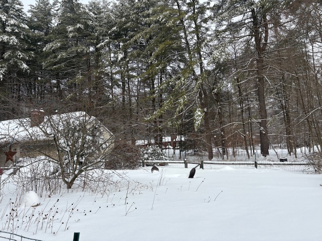
This is my deepest pack of the season right now. You can see those faux Adirondack chairs by my fire pit are buried.
-
the op has been all over the place, not really "going cold"
-
I hope the GFS is wrong. Not because I don't want the Mass weenies to get snow but I really could do without ZR. Almost couldn't bring out the garbage bins last night without falling on my ass.
-
Agree. Big potential but time is running out.
-
GFS looks good. 33 and rain south of the pike, grid gone Pike North.
-
Torchy out there. 51F
-
There’s a few Met posters here that live in MA that are gonna lose their shite if that happens
-
NOT what weenies like CoastalWx like to see!!!! That would melt all of the snow in Weymouth, and CoastalWx would NOT like that one bit!!
-
Yeah, next wednesday. GFS op went cold, while the AIGFS is still trying for 80
-
Is that for next week ?
-
I'd take the snow over that shit...though I'm sure this will be stricken with the scarlet "X" from DIT...
-
Although I day or two of absurd warmth would not surprise me....Feb 2018 had that, and we have avoided it this season....analog has worked out pretty well, but the timing has obviously been a bit astray.
-
It has a pretty legit ice storm near the pike and into S NH. Snow north of that.
-
My weather app has me in the 80s on Monday and Tuesday.. God I hope that's wrong. Leave that crap for May and beyond
-
EURO AIFS has a pretty cold look roughly 3/16 - 3/22 with 850's 15-22 BN Ohio Valley to MA/NE. After the coming warmth this will feel particularly unwelcome. Cold the second half of March is unlikely to undo the warmth of the first half so not expecting March to finish below normal. As for snowfall, the chances are low but not zero. As others have said not a KU looking pattern but some accumulating snow especially interior not out of the question second half of the month but who really wants it at that point anyway.
-
I hope you enjoyed the Skywarn talk! I'm down in Chatty so I was not there. However, I attended an NWS emergency manager talk in Chatty on Monday that covers the new SPC products. As for the rest of March seems like we might get into a couple cooler weeks starting mid-month. That's more valid East or upper half of the Tennessee Valley. Mid-South could remain warmer. Such a pattern leaves the door open for Mountain snow showers. First we have to get through the mid-term blowtorch. I don't see a reason to forecast a cool depressing spring though. Some back and forth like Carvers mentions seems reasonable. Warm weeks, I'd like to add side orders of southwest flow aloft and CAPE.
-
That seems low In Greensboro Fayetteville and Greenville just off the Jan 31 storm alone
-
Gfs op back to ruining midweek. Probably wrong, but not sure Id be locking 75+ yet either.
-
Taller task where I am...3.5" of dense snow/sleet, then sealed with a glaze.
-
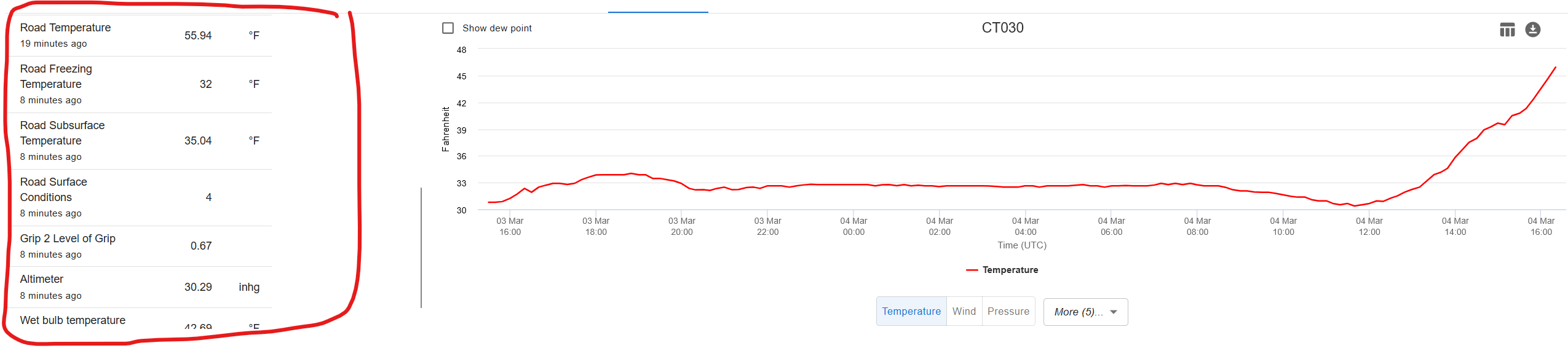
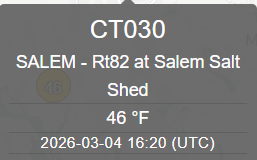
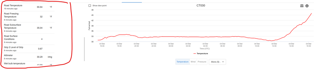
Always like to follow the Salem Salt Shed:


.thumb.png.4150b06c63a21f61052e47a612bf1818.png)