All Activity
- Past hour
-
Flush hit by a cell that blew up west of Gaithersburg and rolled through; will measure when it stops. The pressure is off now for later rounds. Hope everyone gets in on the action!
-

July 2025 Discussion-OBS - seasonable summer variability
lee59 replied to wdrag's topic in New York City Metro
Today is my 8th 90 plus day -

July 2025 Obs/Disco ... possible historic month for heat
HoarfrostHubb replied to Typhoon Tip's topic in New England
Warmer here today than yesterday 85 vs 84 -
Pouring in every direction and I'm in the middle without even a drop. Unreal.
-
Over an inch and still heavy rain.
-

2025 Lawns & Gardens Thread. Making Lawns Great Again
SJonesWX replied to Damage In Tolland's topic in New England
oh believe me, I am with you on that. i still have 100,000 growing in my lawn. funny thing is, when I rake up the acorns, I chuck them in various spots in the woods. One year I had 2 dump carts full of them. Those never grow (probably deer food). but the ones that fall on my lawn, no problem growing and the stupid deer don't eat them. -
It's 89 with a 73 dew point. That sun has destabilized everything. Now just waiting on an outflow to hit some of the old boundaries laid down from yesterday and watch it blossom Sent from my SM-G970U1 using Tapatalk
-
Looks like around 0.4” so far?
-
BULLETIN - IMMEDIATE BROADCAST REQUESTED Special Marine Warning National Weather Service Baltimore MD/Washington DC 221 PM EDT Tue Jul 1 2025 The National Weather Service in Sterling Virginia has issued a * Special Marine Warning for... Tidal Potomac from Indian Head to Cobb Island MD... Tidal Potomac from Key Bridge to Indian Head MD... * Until 345 PM EDT. * At 220 PM EDT, strong thunderstorms were located along a line extending from 16 nm northwest of Key Bridge to 12 nm northwest of Leesylvania State Park to 18 nm west of Aquia Creek, moving east at 20 knots.
-

July 2025 Discussion-OBS - seasonable summer variability
psv88 replied to wdrag's topic in New York City Metro
91 here. Forecast has been busting too low lately. Starting to really rack up the 90s. -
I ask it for hypothetical bets so I can track confidence and see how updated changes reflect in its betting. New data and it's at $92 up from $85-$85 Sent from my SM-G970U1 using Tapatalk
-

July 2025 Obs/Disco ... possible historic month for heat
CoastalWx replied to Typhoon Tip's topic in New England
Lots of 96-99 -
Nice rain shower. .27 so far and coming down!
-
No I pulled up the nam soundings for KMDT and downloaded the images for today from 11am till 8pm then uploaded them and had it walk me through its interpretation circling and annotating what it's looking at so I can learn. That was just the summary. I just now uploaded a bunch of different GOES satellite gifs downloaded from CTP site and gave it current flash flood guidance amounts and asked if It had $100 to bet that someone within 25 miles of camp Hill would see flash flooding today how much would it bet. $85-$95. So it's pretty gung ho on people getting slammed today Sent from my SM-G970U1 using Tapatalk
-
July 2025 Obs/Disco ... possible historic month for heat
CoastalWx replied to Typhoon Tip's topic in New England
Euro near 100 Monday -
If I can get a good rumble of thunder or two I will be happy. I've watched for the past week storms avoid downtown Silver Spring as if it were a leper.
-

July 2025 Discussion-OBS - seasonable summer variability
donsutherland1 replied to wdrag's topic in New York City Metro
So far, Central Park's high today is 88°. Newark has reached 95°. Should Central Park fail to reach 90°, Central Park would record its shortest interval on record between dates where Newark reached 95° or above while Central Park failed to reach 90°. On June 29, 2025, Newark topped out at 95°, while New York City (Central Park) reached 89°. The existing shortest interval is 14 days from May 22, 2021 to June 5, 2021. JFK Airport and LaGuardia Airport have both reached 91° so far today. -
July 2025 Obs/Disco ... possible historic month for heat
CoastalWx replied to Typhoon Tip's topic in New England
I’ve been rapid and mutilated. -
My wife just left BWI heading home. She texted before she left that it was raining so hard that it sounded like it was coming through the roof of our Tucson. Very efficient rain maker already.
-

2025 Lawns & Gardens Thread. Making Lawns Great Again
Damage In Tolland replied to Damage In Tolland's topic in New England
The last thing anyone needs is more Oaks . -

July 2025 Obs/Disco ... possible historic month for heat
40/70 Benchmark replied to Typhoon Tip's topic in New England
87.8 -

July 2025 Discussion-OBS - seasonable summer variability
TheClimateChanger replied to wdrag's topic in New York City Metro
Is there any way someone could get a large mirror, maybe using a drone, to reflect sunlight onto the Central Park ASOS? -
July 2025 Discussion-OBS - seasonable summer variability
donsutherland1 replied to wdrag's topic in New York City Metro
JFK Airport has recorded its 8th 90° or above day this year.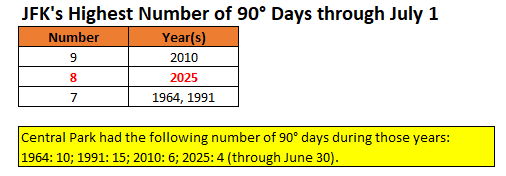
-
Heavy rain here. No thunder, lightning or wind.
-

Central PA Summer 2025
Mount Joy Snowman replied to Voyager's topic in Upstate New York/Pennsylvania
Man that radar is starting to look juicy again. Atmosphere is just a wet sponge that needs wrung out.


