All Activity
- Past hour
-

Rise of the Machines: January 18-19 Winter Storm Obs Thread
Damage In Tolland replied to WxWatcher007's topic in New England
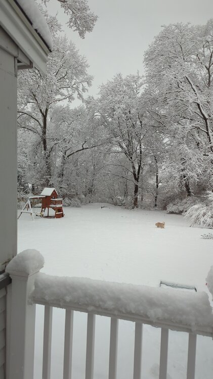
Still have fluffy accumulating snow falling. . Love the hang back . Days and days and days… -
This gives me serious 02 flashbacks and they’re not pretty
-

Winter 2025-26 Medium/Long Range Discussion
Radtechwxman replied to michsnowfreak's topic in Lakes/Ohio Valley
Im in a piss poor spot for anything. Clippers missing me north and the southern stream systems well south. I love cold and dry. Bring on tornado season at this point. -

Rise of the Machines: January 18-19 Winter Storm Obs Thread
amarshall replied to WxWatcher007's topic in New England
I You shall not pass . -

January 2026 regional war/obs/disco thread
jbenedet replied to Baroclinic Zone's topic in New England
You don’t take the op runs over the EPS /GEFS at this stage. Inside day 4 you might start weighing them similarly. -
Low of 16
-
6z EPS temps during the heart of the storm
.gif.6d05716445f53cc674bb5abb697f2702.gif)
-
low of 18. No rain in the bucket from yesterday.
-
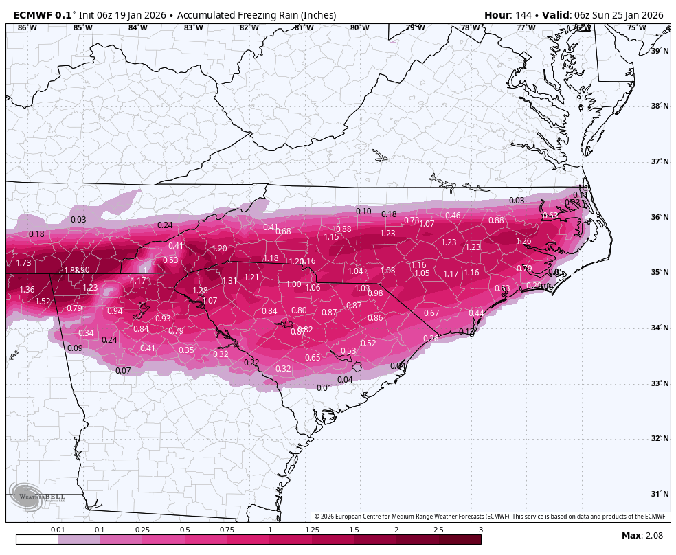
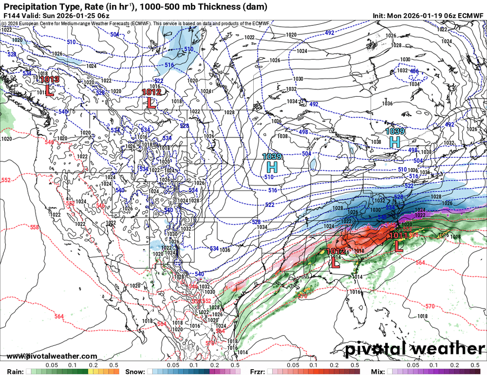
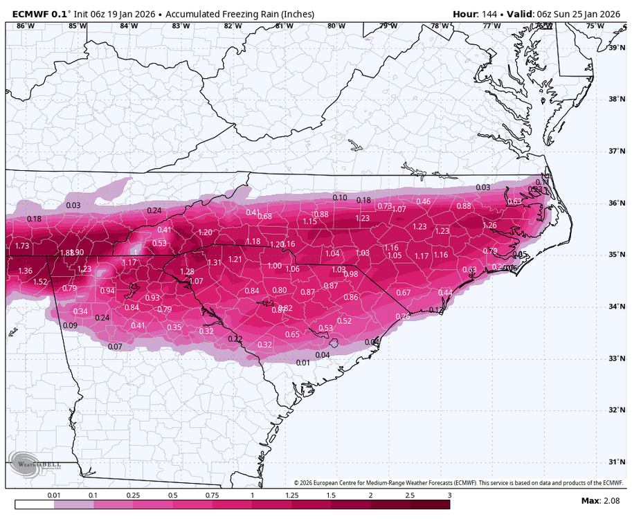
One thing is for sure, this system should have lots of moisture and cold air to work with. The levels of cold air are a different story. As seen in this FR map.
-

Rise of the Machines: January 18-19 Winter Storm Obs Thread
UnitedWx replied to WxWatcher007's topic in New England
Considering the radar last night, surprised to wake up to 2.5 inches, and about 3 in Simsbury -
6z EPS was looking good! Still had plenty to go after that, and temps were locked in to the low 20s and teens!
-

Rise of the Machines: January 18-19 Winter Storm Obs Thread
mahk_webstah replied to WxWatcher007's topic in New England
I didn’t expect to wake up to accumulating snow. It’s light, but I imagine it’s really high ratio fluff because the radar is not impressive at all. looks like the snow is still going nicely in southeast New England -
What's crazy is after this storm, there is a lot of cold air sticking around for a while. Whatever falls aint going anywhere. The ground temps will be cold when it starts falling.. I need sleep gonna be a long week tracking lol
-
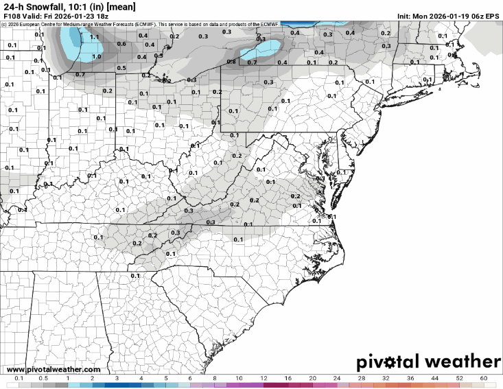
6z Euro at 144
-

Storm potential January 17th-18th
qg_omega replied to WeatherGeek2025's topic in New York City Metro
Sounds right -

Storm potential January 17th-18th
Intensewind002 replied to WeatherGeek2025's topic in New York City Metro
Picked up about 1.9" in total in Lindenhurst -
-
January 2026 regional war/obs/disco thread
mahk_webstah replied to Baroclinic Zone's topic in New England
Suppression risk is high, but we’re five or six days out now so don’t we take the AI models significantly further north output seriously? -
January 2026 regional war/obs/disco thread
jbenedet replied to Baroclinic Zone's topic in New England
North of I80 in PA is out of the game on the weekend threat. -

-
January 2026 regional war/obs/disco thread
jbenedet replied to Baroclinic Zone's topic in New England
-
What’s left on the driveway is a crunchy immovable glacier, looks and feels like real winter again. 18F overnight low. 2 inches measured on a truck bed, bit less on blacktop / walkway. Not bad at all, looking ahead to what seems to be real cold coming our way and hopefully storm chances that aren’t squashed to Georgia.
-
I'd like to see the Eps shift north.
-
Marginally colder too
-

Rise of the Machines: January 18-19 Winter Storm Obs Thread
Bryan63 replied to WxWatcher007's topic in New England