All Activity
- Past hour
-

2025-2026 ENSO
michsnowfreak replied to 40/70 Benchmark's topic in Weather Forecasting and Discussion
Good point. But I was determined to make that list until I ran into a 1990s winter lol (anyone from here will tell you how superior 2000s/2010s winters were to 1990s). I could also arguably put 2020-21 ahead of 1998-99, but the paralyzing snow of Jan 1999, coming after a snowless Fall and anemic 90s winters was a sight to see. Then we had another snow blitz in Mar 1999. -
Pick the warmest and driest model. Ez game.
-
2025-2026 ENSO
michsnowfreak replied to 40/70 Benchmark's topic in Weather Forecasting and Discussion
All of those great except the infamous nightmare of 1995-96. Funny story. In 1994-95 (I was 11) i would sneak outside and measure snow on the back porch and my dad would get mad thinking I was tracking snow in. But the next winter my mom said I could measure with my budding interest in weather, so that began my now 30 winters and counting of continuous snow record (I bought a house a mile from my parents so my record is basically the same location). So 1995-96 was my inaugural year. In the years before internet and stuff i primarily relied on TWC. And i remember vaguely seeing coverage of these monster snowstorms and I kept thinking, why is everything missing us? I ended up with 31.3" but 12" of that came in March, including a 7" power crusher on March 20th. Even in January it was hard to enjoy back to back 2-inch snowfalls knowing they wee originally forecast for us and veered south. In the years since I was able to figure out how the pattern really was, and im SO glad I've never seen anything like it since! -
50/44. Everybody is ready for some warmer weather.
-
For the record, that was intended as an em dash, not a negative sign.
-
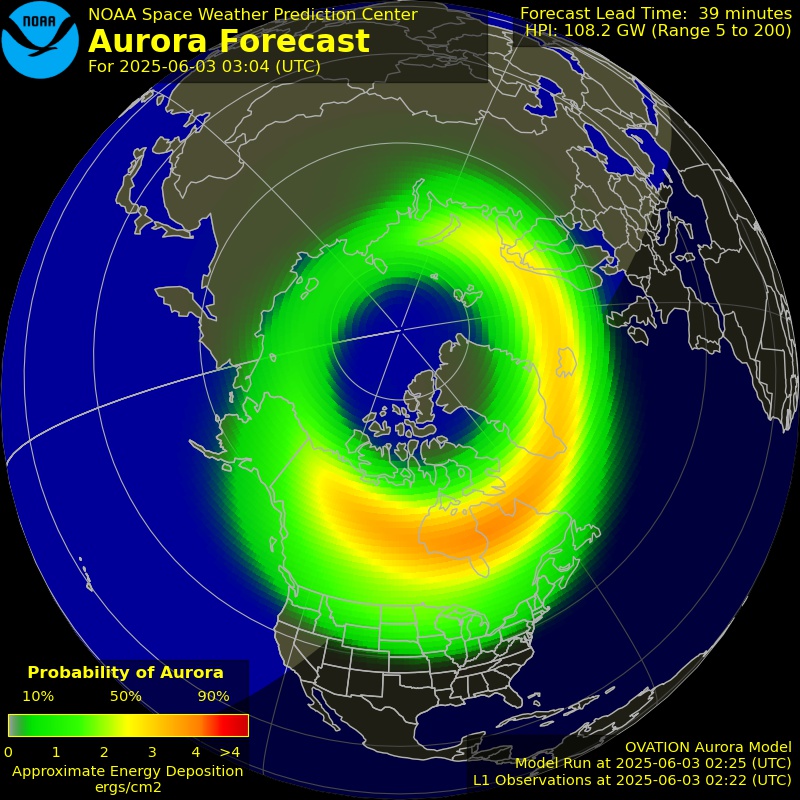
I just checked the semi-dark spot near me where I took the photos last year, but there are too many clouds around.
-
Find a dark sky and look north.
-

2025 Atlantic Hurricane Season
Torch Tiger replied to BarryStantonGBP's topic in Tropical Headquarters
I was more taken back by the 6/5 7/5, nearly every hurricane going major in BOTH basins is a bit weird - Today
-
So is it worth staying up for?
-
I seen Pennlive did a piece on the rain in May, it rained 25 out of the 31 days. It's raining, it's pouring (In May) If you live in central and eastern Pennsylvania, you likely noticed the heavy rain in May. Harrisburg set a record with 10.02 inches of rainfall, more than double the monthly average of 3.83 inches, surpassing the previous record of 9.71 inches from 1989. Rain fell on 25 of the 31 days, with only three dry periods. This consistent rain kept temperatures cooler, with an average high of 71.5 degrees, slightly below the norm. Harrisburg wasn't alone in facing a wet month that disrupted many outdoor events. https://www.pennlive.com/weather/2025/06/how-much-of-a-washout-was-may-across-pa-take-a-look-at-some-of-the-numbers.html?utm_campaign=pennlive_sf&utm_medium=social&utm_source=facebook #pennlive #centralpa #pennsylvania #harrisburg #philly #pa #CentralPA #pennsylvania #PAProud #KeystoneState #ExplorePA #VisitPA #PennsylvaniaAdventures #CentralPALife #PAHistory #MadeInPA #HarrisburgPA #HersheyPA #LancasterPA #StateCollegePA #GettysburgPA #Hersheypark #PennState #HappyValley #SusquehannaRiver
-
All the wet weather/flooding to our west and south might work against big ridging there again this summer which would mean more southerly flow/humid FL type weather vs westerly flow drier heat that can give many of us a chance at 100.
-
Yeah you can envision CNE/NNE getting smoked with pockets of 4-6" easy, hopefully we're on the southern end and get a few bangers instead of just RIPPING rain and cool wx
-
Picture perfect evening.
-
Pretty clear out too.
-
Wait, now the GFS is a trustworthy model for you?
-
There are going to be several different influences on the positioning and speed of the front. Going to be a tremendous deal of convection (well already has been) between what’s been ongoing and the end of the week.
-
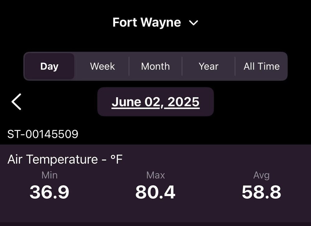
High temp of 75 here today. Beautiful day with the low dewpoints and sunshine. Gonna be interesting to see if we can get a heat wave here Wednesday through Friday. Definitely low-mid 90s on Thursday. Wednesday and Friday are going to be close with high temps near 90.
-
We don’t have a “bread and butter” snow pattern here. We can score in just about every snowstorm setup but also get totally screwed if one part goes awry. Big Miller A moisture bombs common in El Niño are DC’s bread and butter. It gave us our biggest snowstorm ever in Jan 2016 but we also got zilch in the 2/6/10 storm by 20 miles. Miller B late bloomers are Boston’s bread and butter-they can hammer NYC if they form soon enough or the city gets zilch. That’s why NYC is by far the hardest city to forecast for in the winter in a snowstorm setup-small changes mean hammered or cirrus or rain/sleet for a big chunk like in 2/8/13. Lake cutters and SWFEs I assume are yours that are guaranteed for at least something decent 4-5 days out. Those 90% of the time here are cold rain. Marginal setups more and more are cold rain in the city, and the 3-6” type cold clippers have gone extinct.
-
-
52.9° +SHRA Hey why not?
-
We did have a nice diurnal swing today, but not over 100 degrees.
-
possible strong tornado in E Weld County (close to Wyoming. ) I wonder if any storm chasers went out from Fort Collins to see this
-
I wouldn’t think 98-99 would be your kind of winter. Some great snow depth in January for awhile but it certainly wasn’t a cold, snow covered winter overall. I would actually put this past winter above 98-99 for overall wintery feel.
-
It is pretty active now with a south Bz. Don't snooze on tonight.
-

2025-2026 ENSO
40/70 Benchmark replied to 40/70 Benchmark's topic in Weather Forecasting and Discussion
1995-1996 2014-2015 2010-2011 2004-2005 2017-2018 2002-2003

.thumb.png.4150b06c63a21f61052e47a612bf1818.png)