All Activity
- Past hour
-
Yeah, we'll see. I don't disagree with anything you've said. It's worth mentioning is all. Not saying anyone should believe anything... that's on them.
-
we should just make this futility thread considering who made it and the stupid title it has, just post all the garbage, meltdowns and whining and complaining in here, why not.
-

January 2026 regional war/obs/disco thread
WinterWolf replied to Baroclinic Zone's topic in New England
In all fairness Anthony, I don’t think anybody cares about LE here in SNE. I mean good for them, but that doesn’t float anybody’s boat in SNE. -

January 2026 regional war/obs/disco thread
ORH_wxman replied to Baroclinic Zone's topic in New England
Yeah the joint EPO/PNA ridge....kind of like 2015. Usually doesn't verify these days, but I'd take even just the PNA part since antecedent cold in Canada will already be good. -
Low of 28, high of 50. Almost forgot what it is like to be cold.
-
I do have a question. You have mentioned the wave lengths get shorter in February? If I remember correctly? What does that refer to or mean?
-
Gfs with two decent snows on it this run. Be curious to see Gefs if they light up more.
-
The Pacific has to slow down and allow a better/more stout PNA ridge without so much interference from 10000 shortwaves. Period. I can't speak for the 1980s or other lean snow periods here but I'm with those who have to see the KU setup within 72hrs to believe it. Maybe these long range ensembles are biased too heavily to the 1990s/2000s climate, someone with better knowledge can explain. We lucked out with the two clipper like systems but normal for us is still a good bit higher. Feb seems like when we can finally make a bigger ticket event happen like in 2021 and 2024, hopefully we can do that this year.
-
Alot of trolls
-
Lake areas are going to get slammed coming up. Wouldn't be shocked to see Owesgo hit 200 inches.
-
And we are still in a retrograding pattern at 500. Just watch the ridge. Every time a trough comes through, it pops back up further west. The EPO looks like it wants to hold, but when it gets pushed out....up goes the SER and then it retrogrades. Weeklies update for today....see the comment I just made. Seasonal to BN temps as base pattern but with warmth(some very warm days) embedded w/ those ridges. Retrograding ridges and troughs. I think we eventually see the TPV get trapped(have I said that prior?) under HL blocking. That is when the real fun and games might begin.
-
Through Wednesday, highs will generally reach the 40s during the daytime and 30s for lows in New York City. Somewhat colder readings are likely outside the City and in areas where strong radiational cooling takes place. After the middle of next week, temperatures will "step down" with highs mainly in the middle and upper 30s in New York City and lows in the middle and upper 20s. Some light precipitation is possible on Friday. Rain showers could transition to a period of snow. A light accumulation is possible. Some additional precipitation could arrive on Sunday. No significant Arctic blasts or significant snowfalls are likely through at least mid-January. Afterward, conditions might become more favorable for both cold and snowfall, especially if the PNA remains predominantly positive, as has often occurred following the breakdown of long-duration PNA- regimes. PNA-related developments would have larger implications for snowfall. A persistently positive PNA would have above climatological risk of moderate or significant snowfalls. A mainly negative PNA would favor mainly small snowfalls. It will likely be another day or two before the guidance reaches the high-skill timeframe for teleconnection forecasts. The ENSO Region 1+2 anomaly was -0.7°C and the Region 3.4 anomaly was -0.8°C for the week centered around January 7. For the past six weeks, the ENSO Region 1+2 anomaly has averaged -0.47°C and the ENSO Region 3.4 anomaly has averaged -0.67°C. La Niña conditions will likely continue into at least late winter. The SOI was +12.16 today. The preliminary Arctic Oscillation (AO) was -1.040 today. Based on sensitivity analysis applied to the latest guidance, there is an implied near 55% probability that New York City will have a cooler than normal January (1991-2020 normal). January will likely finish with a mean temperature near 33.5° (-0.2° below normal). Supplemental Information: The projected mean would be 0.9° above the 1981-2010 normal monthly value.
-

E PA/NJ/DE Winter 2025-26 Obs/Discussion
Snowguy66 replied to LVblizzard's topic in Philadelphia Region
Tough loss yesterday. The 49ers were very gritty. With all of those players, they're missing and losing their best tight end. I can't believe the Eagles couldn't pull that one out. I thought the Eagles got a break playing them as a third seat, but I guess not. Always next year. Any given Sunday. -
A long time ago he had some sort of anonymity issue over something.
-
January 2026 regional war/obs/disco thread
WinterWolf replied to Baroclinic Zone's topic in New England
Way out there though. Hold that look as we close in would be nice. -
January 2026 regional war/obs/disco thread
WinterWolf replied to Baroclinic Zone's topic in New England
Well we do have a lot here that feel everything is going to fail from here on (1/12) out. You know the new norm and all that nonsense . But maybe the GFS won’t be alone with some of these chances as we close in. I mean 1/24 is way out there in clown range..I was more talking about the 18th. -
It’s just freaking incredible
-
Just looking at the 12z EPS which can have a warm bias. First image is the d10-15 blend. NAO block, EPO ridge, AN heights over Alaska, trough east of Hawaii. That is a storm signal - Miller B or A or both. Below is the temp map for d10-15. Remember, if you want big winter storms, you have to be wiling to ride the boundary on an west to east gradient. Below is a single day snapshot so as not to wash out how cold it may get. This is January and below normal temps in January are cold. See the gradient? Single image at the end of the EPS. This is the 18z GFS at 288. This is generally what I think we are going to see occur. The pattern over the top supports it, and the MJO probably does as well. Blocking in the NAO, AO, and EPO/Alaska regions. This creates a gradient pattern, and that is my 1b "go to" pattern. 1a is an inland runner. I do think we see yet another ridge roll through after this....wash...rinse...repeat through February. But see how the cold descends into the Canadian Prairie. That is generally a good spot for us.
-

January 2026 regional war/obs/disco thread
CoastalWx replied to Baroclinic Zone's topic in New England
End of EPS probably the best PAC look all season. -
A nice simple way to get something. Let's see if the general idea survives to Saturday
-
Almost a banger here just need a bit more south.
-

Winter 2025-26 Medium/Long Range Discussion
sbnwx85 replied to michsnowfreak's topic in Lakes/Ohio Valley
GFS moves the main band over South Bend. I'm all in. 12"+ or bust. -

January 2026 regional war/obs/disco thread
Damage In Tolland replied to Baroclinic Zone's topic in New England
Hopefully a few folks fall thru the ice -

January 2026 regional war/obs/disco thread
brooklynwx99 replied to Baroclinic Zone's topic in New England
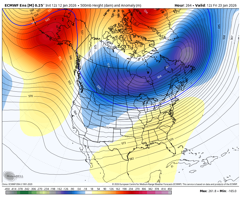
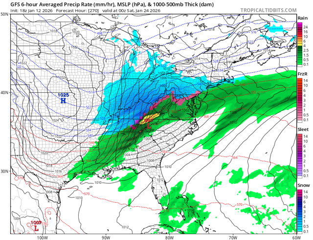
yeah, the 22-24th is a solid timeframe with established cold air, low heights over SE Canada, and some -NAO/-EPO. can see how you'd get something ejecting out of the west into cold air
-
January 2026 regional war/obs/disco thread
ORH_wxman replied to Baroclinic Zone's topic in New England
No, why would anyone “trust” guidance this far out for anything? But I’m not going to get overly emotional and assume everything will fail because the previous events failed. It’s actually a good sign that we’re getting some hits in the extended on OP runs. GFS likes 1/24 too and so did EPS.