All Activity
- Past hour
-

July 2025 Obs/Disco ... possible historic month for heat
Damage In Tolland replied to Typhoon Tip's topic in New England
It was a surreal scene tonight. They were zooming all over the downstairs from window to window . Add in the dogs barking because of all the slapping on the windows.. it definitely took a few years off my life -

July 2025 Discussion-OBS - seasonable summer variability
SACRUS replied to wdrag's topic in New York City Metro
Last of the visble loops and you can see the clouds into W Q-NY and W-PA likely 10 - 12 hours transport has us cloudy in the morning, we'll see if enough sun can get anyone to 90 tomorrow. -
July 2025 Obs/Disco ... possible historic month for heat
Damage In Tolland replied to Typhoon Tip's topic in New England
Well it’s your fault for believing it lol. You also thought all the heat would stay SW of us and that Julorch wouldn’t be in top 5 hottest -

July 2025 Discussion-OBS - seasonable summer variability
psv88 replied to wdrag's topic in New York City Metro
Light rain and 82. Just enough rain to make it nasty outside -
 Low pressure moving along a nearly stationary front produced heavy thunderstorms with flash flooding in parts of the region. A snippet from the NWS: 000 TTAA00 KNYC 311600 FFWNYC NYC047-059-081-103-NYZ501-311800- BULLETIN - EAS ACTIVATION REQUESTED FLASH FLOOD WARNING AND SPECIAL MARINE WARNING NATIONAL WEATHER SERVICE NEW YORK NY 1200 PM EDT WED JUL 31 1996 THE NATIONAL WEATHER SERVICE IN NEW YORK HAS ISSUED A FLASH FLOOD WARNING AND SPECIAL MARINE WARNING EFFECTIVE UNTIL 200 PM EDT FOR THE PEOPLE IN THE FOLLOWING LOCATIONS... IN SOUTHEAST NEW YORK ...KINGS COUNTY...NASSAU COUNTY...QUEENS COUNTY ...WESTERN SUFFOLK COUNTY ...AND THE ADJACENT COASTAL WATERS A FLASH FLOOD WARNING IS NOW IN EFFECT FOR WESTERN SUFFOLK... NASSAU...QUEENS...AND KINGS COUNTIES UNTIL 2 PM. A SPECIAL MARINE WARNING IS ALSO IN EFFECT FOR THE COASTAL WATERS FROM SANDY HOOK TO MORICHES INLET UNTIL 2 PM. A STRONG LINE OF THUNDERSTORMS CONTINUES TO EFFECT THE WARNING AREA PRODUCING TORRENTIAL RAINS...AND DANGEROUS LIGHTNING. THESE THUNDERSTORMS HAVE CAUSED WIDESPREAD STREET...ROADWAY...AND BASEMENT FLOODING. AT 1200 PM THE HEAVIEST RAINS ARE OCCURRING OVER NASSAU COUNTY AND THE COASTAL WATERS SOUTH OF JONES BEACH. THE STORMS WILL EFFECT WESTERN SUFFOLK COUNTY AND ADJACENT WATERS SHORTLY. CONDITIONS WILL SLOWLY IMPROVE OVER QUEENS AND KINGS COUNTY BY 1 PM AS THE LINE OF THUNDERSTORMS MOVES EAST. THESE STORMS HAVE BEEN PRODUCING HEAVY FLOODING RAINS AND FREQUENT DANGEROUS LIGHTNING AND COULD PRODUCE GUSTY WINDS AND SMALL HAIL.
 -

Chester County PA - Analytical Battle of Actual vs. Altered Climate Data
CAPE replied to ChescoWx's topic in Climate Change
Not sure why anyone bothers to debate this dude. Futile. Let him keep posting his flawed agenda driven data. I'm sure he will start replying to himself. -

Central PA Summer 2025
Mount Joy Snowman replied to Voyager's topic in Upstate New York/Pennsylvania
You know, I saw that happening earlier and was wondering if you were just inside of that cell. Amazing. -
Highs: TEB: 100 EWR: 100 LGA: 99 PHL: 97 ACY: 97 New Brnswck: 96 ISP: 96 NYC: 95 TTN: 95 JFK: 95 * no intra hour readings BLM: 92 * missing most data (7/29-7/30)
-
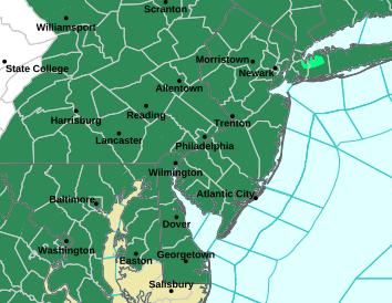
Rather impressive area of flood watches.
-

July 2025 Obs/Disco ... possible historic month for heat
Torch Tiger replied to Typhoon Tip's topic in New England
My last house had winged ants through a rotted wood floorboard and interior at front door. It only took two seasons, one season with a few , but second year there were thousands and thousands...so I just set up two vacuums and it ran nearly 24/7, very few got in. lol And fixed that shit -
will post them here as they get released (nobody will read them anyway) mh h ts td ----------------------------------------------------------------------------------------------------------------------------------------------------------------------- atlantic nobody yet ----------------------------------------------------------------------------------------------------------------------------------------------------- eastern pacific alvin flossie
-
 seems like a run of the mill event now vs the big totals we saw a couple days ago. we do need the rain!
 -

July 2025 Discussion-OBS - seasonable summer variability
nycwinter replied to wdrag's topic in New York City Metro
76 in the city after the heavy downpour -
July 2025 Discussion-OBS - seasonable summer variability
SACRUS replied to wdrag's topic in New York City Metro
Highs: TEB: 100 EWR: 100 LGA: 99 PHL: 97 ACY: 97 New Brnswck: 96 ISP: 96 NYC: 95 TTN: 95 JFK: 94 * no intra hour readings BLM: 92 * missing most data (7/29-7/30) -

July 2025 Obs/Disco ... possible historic month for heat
Hailstoned replied to Typhoon Tip's topic in New England
Where's there's rot there's flies you've got. -
Almost 7" for the month here and already dry af. 5 days without rain this time of year and its like it never rained lol. All the trees and super well drained soil..
-
That's it? Sent from my SM-G970U1 using Tapatalk
-
Hop on scannerfood on Facebook and u can see the flooding.
-
 wow that was a lot of rain on July 31, 1996-- over 3.5 inches at JFK, what happened Don? I remember Bertha from July 1996 but that was much earlier in the month!
 -
July 2025 Obs/Disco ... possible historic month for heat
Torch Tiger replied to Typhoon Tip's topic in New England
that's disgusting lol -
July 2025 Discussion-OBS - seasonable summer variability
LibertyBell replied to wdrag's topic in New York City Metro
I didn't even hear thunder -
July 2025 Obs/Disco ... possible historic month for heat
Torch Tiger replied to Typhoon Tip's topic in New England
vacuum, sir. lol -
July 2025 Discussion-OBS - seasonable summer variability
LibertyBell replied to wdrag's topic in New York City Metro
SW Nassau didn't even go completely cloudy lol -
July 2025 Obs/Disco ... possible historic month for heat
Torch Tiger replied to Typhoon Tip's topic in New England
wowzers -
July 2025 Discussion-OBS - seasonable summer variability
LibertyBell replied to wdrag's topic in New York City Metro
so maybe it won't be like 2011 after all lol


