All Activity
- Past hour
-
(002).thumb.png.6e3d9d46bca5fe41aab7a74871dd8af8.png)
Central PA Winter 25/26 Discussion and Obs
ChescoWx replied to MAG5035's topic in Upstate New York/Pennsylvania
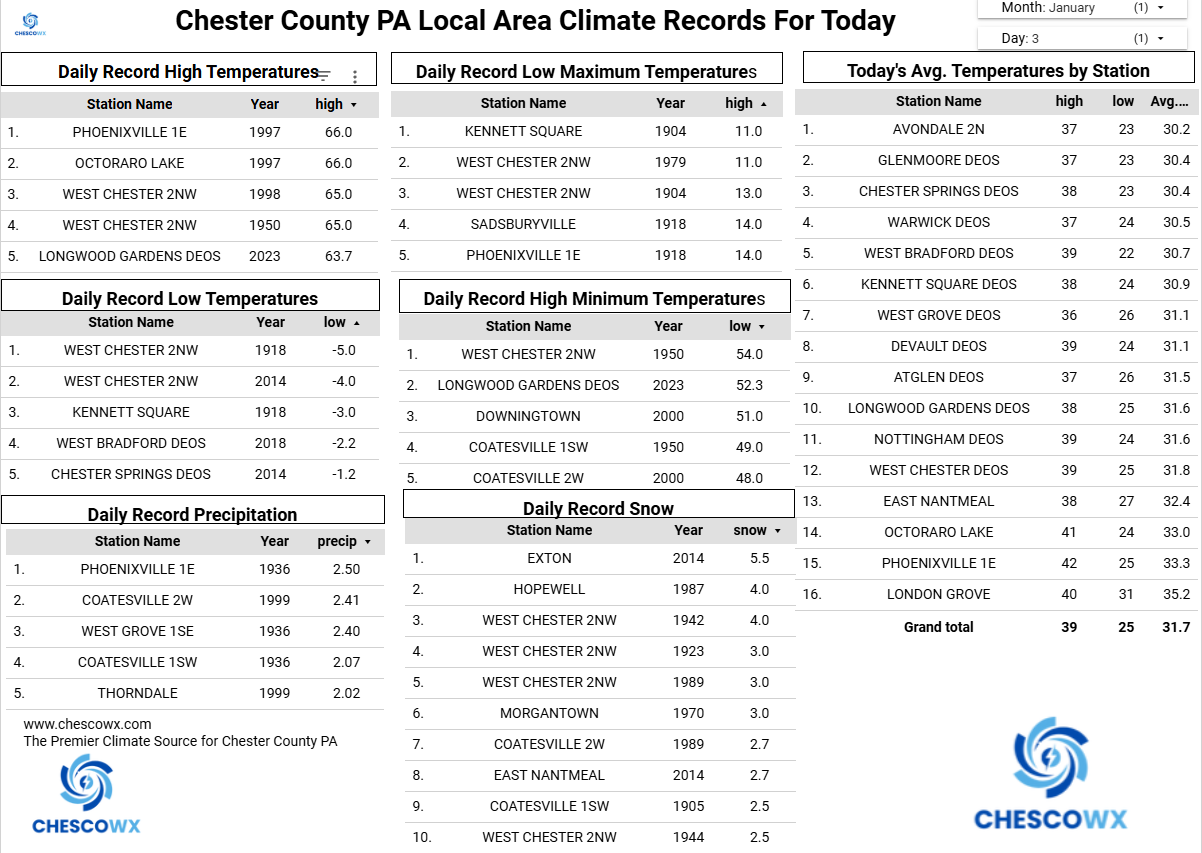
If you think we were running colder than normal the entire holiday season you are correct. In the 37 days since Thanksgiving day 31 of those days have featured below normal temperatures. We should have another 3 days of below normal temperatures before we finally see an above normal temperature day on Tuesday. In fact, that day should begin a streak of well above normal temperatures that should last for about 6 days before we look to potentially trend back to below normal by next Monday. There is a slight chance of some flurries tonight with our next rain chance arriving by Thursday night.

-
E PA/NJ/DE Winter 2025-26 Obs/Discussion
ChescoWx replied to LVblizzard's topic in Philadelphia Region
If you think we were running colder than normal the entire holiday season you are correct. In the 37 days since Thanksgiving day 31 of those days have featured below normal temperatures. We should have another 3 days of below normal temperatures before we finally see an above normal temperature day on Tuesday. In fact, that day should begin a streak of well above normal temperatures that should last for about 6 days before we look to potentially trend back to below normal by next Monday. There is a slight chance of some flurries tonight with our next rain chance arriving by Thursday night.
-
All 3 models have moved away from a SER at d15/16. That's why I don't get why anyone worries about the pattern depiction that far out, esp given how this has gone for months now. Any suggestion of protracted warmth is muted/ doesnt materialize.
-
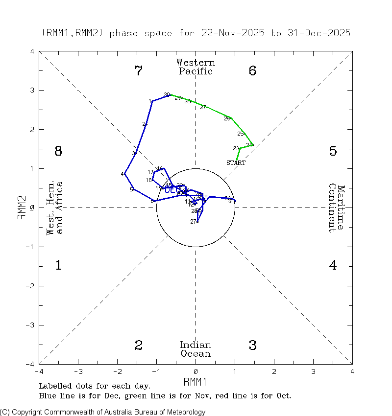
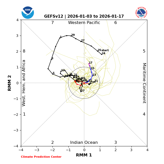
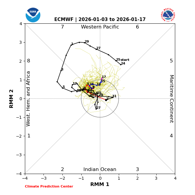
Today’s ens MJO progs both later get into 6: inside circle 6 would be best for cold chance during ph 6 as just posted: also Jans with 20+ days anywhere inside circle have averaged colder than the others as I posted about before:
-

Central PA Winter 25/26 Discussion and Obs
Blizzard of 93 replied to MAG5035's topic in Upstate New York/Pennsylvania
Key word is a bit… This warm up is brief. Winter returns by the 12th -

January 2026 regional war/obs/disco thread
ORH_wxman replied to Baroclinic Zone's topic in New England
After lots of clippers and moose fart upslope events that drop coatings everywhere that isn’t on the mountain spine, a lot of us will roll the dice for some meatier events that carry a cutter risk. Esp going into heart of coldest climo. -
January 2026 regional war/obs/disco thread
ORH_wxman replied to Baroclinic Zone's topic in New England
I actually like the WAR location there. We had that frequently for a few years in the 2016-2018 timeframe which brought some storms back from the dead that were out to sea. The one worry is the epo ridge retrogrades west with time which can introduce more cutter potential. -
Yeah this next 5-7 days is definitely gonna be above average temp wise for a large majority of the lower 48 outside of the west coast. It could be record highs in some areas from the looks of it. As John mentioned earlier it’s gonna be another huge weekend for the snow lovers in California!! As for us in the Tennessee Valley I do think we’re headed in the right direction based off what we’re seeing in long term guidance, we’ve just gotta get through a warm week to get there!
-
My car wasn’t topped last night. We’re due!! 24F
-

Central PA Winter 25/26 Discussion and Obs
Mount Joy Snowman replied to MAG5035's topic in Upstate New York/Pennsylvania
Low of 19. Solid winter days here before we warm up for a bit. -
A little snow

-
Well, as it turned out again using GSP, El Niño ph 6 near or inside the circle in Jan turns out to avg cold just like La Niña inside Jan ph 6: Phase 6 during Nino Jan 77 6-9, 11-13: -7, -4, -11, -7, -20, -15, -13 (-11 W) 78 4: -6 (-6 W) 80 31: -13 (-13 W) 83 10-1: +1, +3 (+2 W) 92 3-8: +10, +13, +8, +6, +2, +1 (+7 W) 95 28-30: +1, -6, -7 (-4 W) 98 1-3, 21-2: -12, 0, +6, -3, -3 (-2 M)(-3 W) 03 10-12, 23-5: +5, -6, -10, -16, -19, -10 (-4 M)(-15 W) 05 9-19, 31: +10, +11, +11, +18, +22, +7, -1, -2, -13, -15, -14, -1 (+3 M)(-1 M) 07 9-13, 15-6, 24, 26-31: -1, -3, -4, +5, +16, +21, +5, -3, -5, +5, -2, -15, -2, -12 (+6 M)(-5 W) 10 20-1: +15, +3 (+9 M) 15 9-14, 28-31: -8, -11, -10, -1, -1, -4, -3, -2, 0, -4 (-6 S)(-2 W) 19 2-3, 25-30: +10, +11, -4, -5, -3, +1, -3, -9 (+11 S)(-4 S) 24 24-7: +6, +17, +21, +12 (+14 S) So, there were 20 Nino Jan ph 6 periods: 10 W: 3 MB, 4 B, 2 N, 1 A; avg -158/36 = -4.4 for weak! 6 M: 1 B, 2 N, 2 A, 1 MA avg +43/27 = +1.2 for moderate 4 S: 2 B, 2 MA +19/18 = +1 for strong 81 days BN 39 NN 16 AN 26 -66 cumulative or -1/day overall but cold concentrated when near/inside circle (-4 there vs +1 outside) similar to La Niña! For La Niña, it was overall -2/day with it averaging -5/day near/inside circle and +1 outside. So, the BAMwx idea of a cold E US during ph 6 in Jan in -AAM works out only for weak/mainly inside the circle and Nino is similar.
-
It is reminiscent of a couple of winters ago when the ensembles and operationals kept showing the MJO going through phases 8-1-2 at high amplitude in the long range over and over again for months….it never happened. I believe it was the 2023-24 winter
-

January 2026 regional war/obs/disco thread
WinterWolf replied to Baroclinic Zone's topic in New England
Lol…good one Go Kart. For a half inch..I’ll pass on this one. -
Possible sleet earlier this morning pinging on the windows. Drizzle and 39.
-

January 2026 regional war/obs/disco thread
Sey-Mour Snow replied to Baroclinic Zone's topic in New England
It’s not a bad look though for us , any colder down south on that look and we’d be cold and dry, we need some SE ridge to get some action. -

January 2026 regional war/obs/disco thread
Go Kart Mozart replied to Baroclinic Zone's topic in New England
Where is WinterWolf and what have you done with him? -
Better west coast ridging across the board last night. That made a world of difference on the outlook for cold on the east coast. Let’s see if we can keep the positive trends going.
-
January 2026 regional war/obs/disco thread
WinterWolf replied to Baroclinic Zone's topic in New England
Please…I hope nothing falls here tonight. Washed the truck yesterday, and don’t need any more slop for a week now with the thaw coming. We reshuffle for after the 11th-12th. -
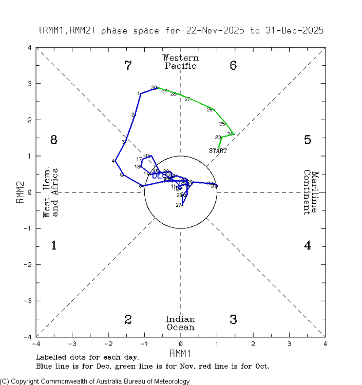
As we look ahead to Jan, here’s the wrap for Dec MJO: the last 12 days (12/20-31), which covered the torch period, turned out to track in 7-6-4-3-5, not well predicted by the models and which is typically not a cold path and can easily be mild: The coldest day of the month in the E US was during phase 8 and phase 8 overall was the typical cold. It never was able to get into 1 and instead took a detour across eventually to 5! Nothing even close to that had been predicted. Remember all of those endless ph 8 progs?
-
As we look ahead to Jan, here’s the wrap for Dec MJO: the last 12 days (12/20-31), which covered the torch period, turned out to track in 7-6-4-3-5, not well predicted by the models and which is typically not a cold path and can easily be mild: The coldest day of the month in the E US was during phase 8 and phase 8 overall was the typical cold. It never was able to get into 1 and instead took a detour across eventually to 5! Nothing even close to that had been predicted. Remember all of those endless ph 8 progs?

- Today
-
I think some Nina winters are just a struggle to get precip. I think I noted in for my winter ideas (back in June) that fall should be dry. IMBY, we have done ok. West of me....not so much. Some Nina patterns can be the exact opposite of dry. There is a bank of analogs which brings flooding rains after fall and into spring and the next summer. I would expect, especially w/ Nino incoming over the summer, that the drought situation should moderate by late summer at the latest. Modeling has been generally honking that we should see increased moisture over the next two months, but I am not holding my breath as it "appears" they are struggling to handle even the EPO ridge at almost short range.
-
The reason for these Chi coldest of run posts is because of it being a source region since a lot of SE cold travels from that area. It’s extremely hard for the SE to get colder than Chi (outside of mtns) as the air traveling from there modifies as it comes SE and even more w/o snowcover.Whereas the 0Z GFS suite stayed the same (quite mild) as the 12Z despite the Euro suite getting sig. colder post Jan 6th, the 6Z GFS suite did trend a notable amount colder even though it’s still mainly mild (normal lows upper teens) (ens means are the most important that far out) Coldest post Jan 6th of GFS/GEFS:12Z +30/+250Z +29/+256Z +21/+21
-

January 2026 regional war/obs/disco thread
HoarfrostHubb replied to Baroclinic Zone's topic in New England
When I was up around 5:30 to let the dog out, we had some flakes. might be all we get this upcoming week -

E PA/NJ/DE Winter 2025-26 Obs/Discussion
Birds~69 replied to LVblizzard's topic in Philadelphia Region
Looks to be a wintry looking day. Clouds and temps in the 20s and low 30s. Maybe a couple snow showers overnight? Dusting? Car topper? 23F